

According to Public Safety Canada (2019), tornadoes, high winds and thunderstorms caused crop damage and destruction of several buildings in the communities of Lobo, Komoka, Frome, Port Stanley, Southwold and Kendall where six minor injuries were reported. Striking at 4:10pm, the tornado caused extensive damage in the small village of Komoka, to the west of London. The solidly built Komoka Community Church was levelled to the ground, however its minister escaped what would have surely been serious injury or death, having left the building minutes before it was swept away. The church organ was smashed and debris that included bibles and collection cans was tossed through area fields. Pieces of the building’s roof were scattered over a kilometre away. Across the street, a house was also destroyed, its roof torn off, and walls pock-marked by debris. Throughout the community, trees were snapped and uprooted and barns damaged and destroyed.
Striking at 4:10 pm, the tornado caused extensive damage in the small village of Komoka, to the west of London. The solidly built Komoka Community Church was levelled to the ground, however its minister escaped what would have surely been serious injury or death, having left the building minutes before it was swept away. The church organ was smashed and debris that included bibles and collection cans was tossed through area fields. Pieces of the building’s roof were scattered over a kilometre away. Across the street, a house was also destroyed, its roof torn off, and walls pock-marked by debris. Throughout the community, trees were snapped and uprooted and barns damaged and destroyed.
This was one of three tornadoes to touch down in Southern Ontario on August 28.
The Forecast
According to Environment Canada (1990), a sharp cold front was crossing southern Ontario on the late afternoon of August 28, 1990 (Figure 1).
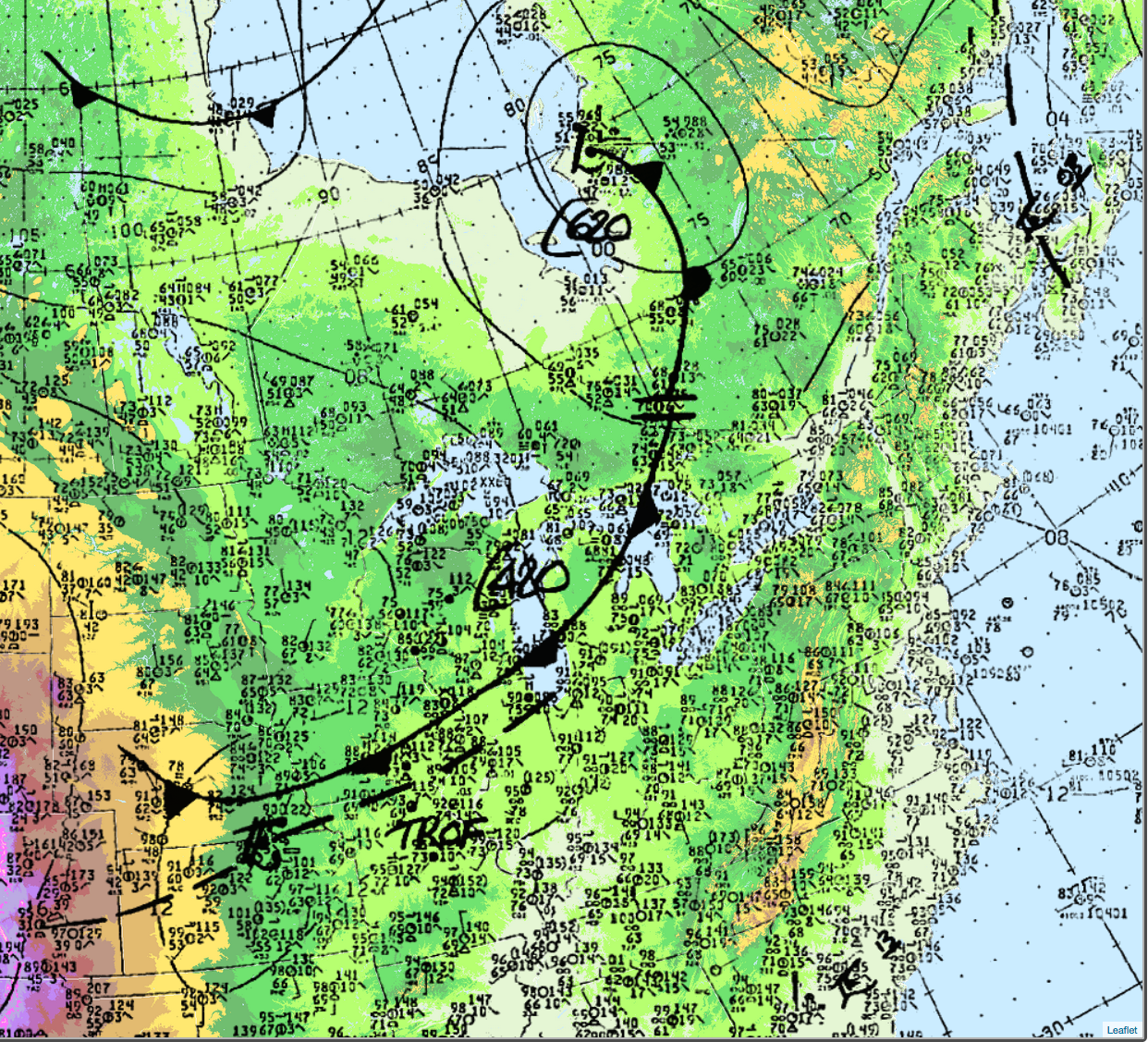
The cold front would become the focus for intense convection later in the day for southern Ontario.
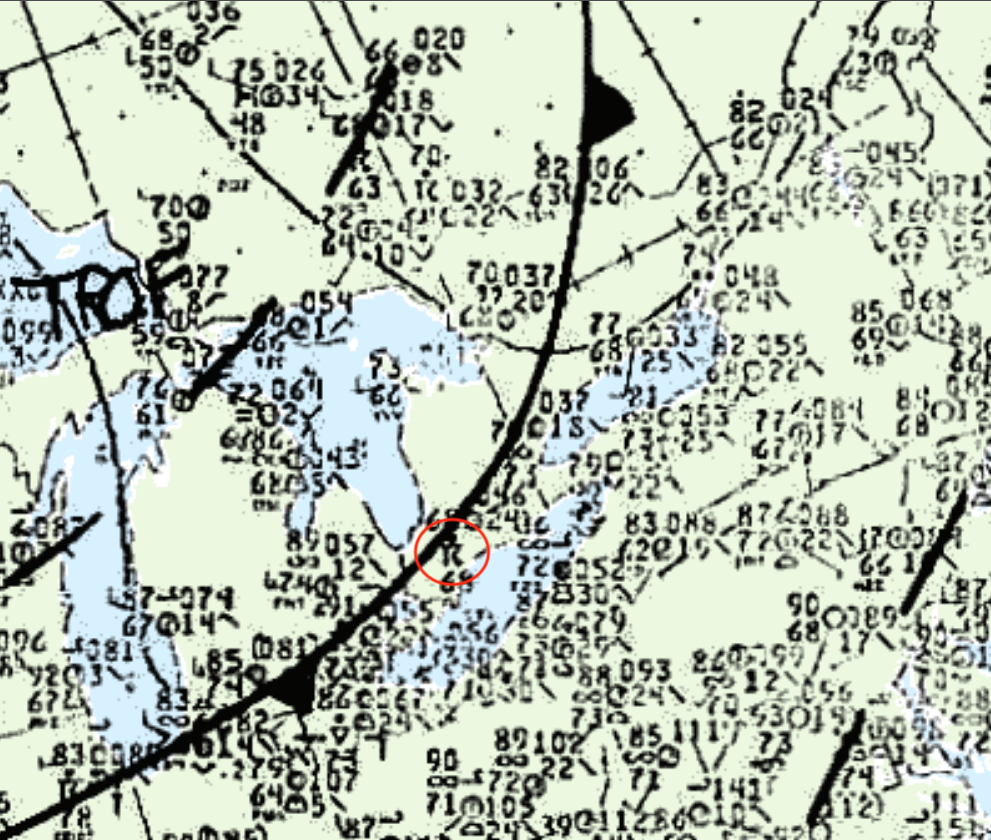
Figure 2 depicts the positioning of the cold front and the thunderstorm that developed along it. Figure 2 is a depiction 30 minutes prior to the F3 tornado that developed and impacted Port Stanley.
Recap
According to ECCC (2018), the Komoka F2 tornado touched down in Komoka, ON northwest of Glendon Drive at 4:10 pm local time. ECCC (2018) has not documented a track length, but according to Environment Canada (1990), Frome, ON suffered substantial property damage, with up to 80% of the homes being destroyed. This would roughly put the path length of this tornado to 22 km, moving in a south-southeasterly direction and ending around Frome. The maximum width of the tornado was not documented. The F2 tornado caused no fatalities or injuries. The amount of property damage was not documented by ECCC (2018).
Sources
Public Safety Canada. (2019). Canadian Disaster Database. Retrieved from: https://cdd.publicsafety.gc.ca/prnt-eng.aspx?cultureCode=en-Ca&provinces=9&eventTypes=%27EP%27%2C%27IN%27%2C%27PA%27%2C%27AV%27%2C%27CE%27%2C%27DR%27%2C%27FL%27%2C%27GS%27%2C%27HE%27%2C%27HU%27%2C%27SO%27%2C%27SS%27%2C%27ST%27%2C%27TO%27%2C%27WF%27%2C%27SW%27%2C%27EQ%27%2C%27LS%27%2C%27TS%27%2C%27VO%27&normalizedCostYear=1&dynamic=false
Environment Canada (1990, Aug 27 to Sept 2). A weekly review of Canadian climate and water. Climatic Perspectives, Vol. 12, No 35, p.1. Retrieved from: http://publications.gc.ca/collections/collection_2018/eccc/en58-22/En58-22-12-35-eng.pdf
NWS Weather Prediction Center. (2017). Surface analysis 18Z Tue Aug 28 1990. Retrieved from: https://www.wpc.ncep.noaa.gov/archives/web_pages/sfc/sfc_archive.php
Environment and Climate Change Canada (2018). Canadian National Tornado Database: Verified Events (1980-2009) – Public. Retrieved from: http://donnees.ec.gc.ca/data/weather/products/canadian-national-tornado-database-verified-events-1980-2009-public/?lang=en