

This tornado touched down at 8:12 pm, then remained on the ground for twenty-three minutes as it tore to the southeast across southern sections of the city. It was a large and ominous cone tornado that was fully condensed to the ground, churning with debris from trees and buildings, a shocking and terrifying sight for residents of the city as they watched it tear through.
The tornado initially touched down in Silvercreek Park where trees were twisted, snapped and uprooted, and it continued to cause tree damage as it moved out of the park and into residential streets. It passed along and adjacent to Edinburgh Road South and steadily increased in intensity as it approached Harts Lane West. There, a farm was struck, its house and outbuildings receiving extensive F1 damage. Southeast of there, in the Hamilton Corner area, it tore apart the Arkell Church, sweeping away the building’s cloakroom and tearing up roofing and siding.
Next the tornado took a slightly more easterly jog, tearing through the heavily-populated Pine Ridge subdivision. Dozens of houses were significantly damaged with windows shattered and sections of roof ripped off. At one house, the entire garage and most of the roof were torn away and scattered. Another house under construction was levelled entirely. Throughout the neighbourhood, trees were snapped and uprooted and power poles knocked down. Fifty homes in the subdivision suffered heavy damage and several families were displaced.

Guelp Tribune 
Observer 
The Guelph Mercury 
The Guelph Mercury 
The Toronto Star
The tornado was captured in photographs and on video by a number of witnesses, a large cone that was fully condensed to the ground with the debris from houses lofted high in the air and swirling at its base. One woman suffered minor injuries and was treated for bruising, and preliminary estimates put the damage at over $2,000,000. The original damage survey of the Guelph tornado, conducted by Environment Canada researcher David Sills, is available here.
This was the most damaging of three tornadoes to touch down in South Central Ontario on July 17, 2000. The others:
Forecast Background
Figure 1 depicts the surface observations at 2:00 pm, which shows a cold front advancing toward southern Ontario. This eastward-moving front would have brought southerly winds blowing over Lake Erie and Lake Ontario across southern Ontario throughout the afternoon.
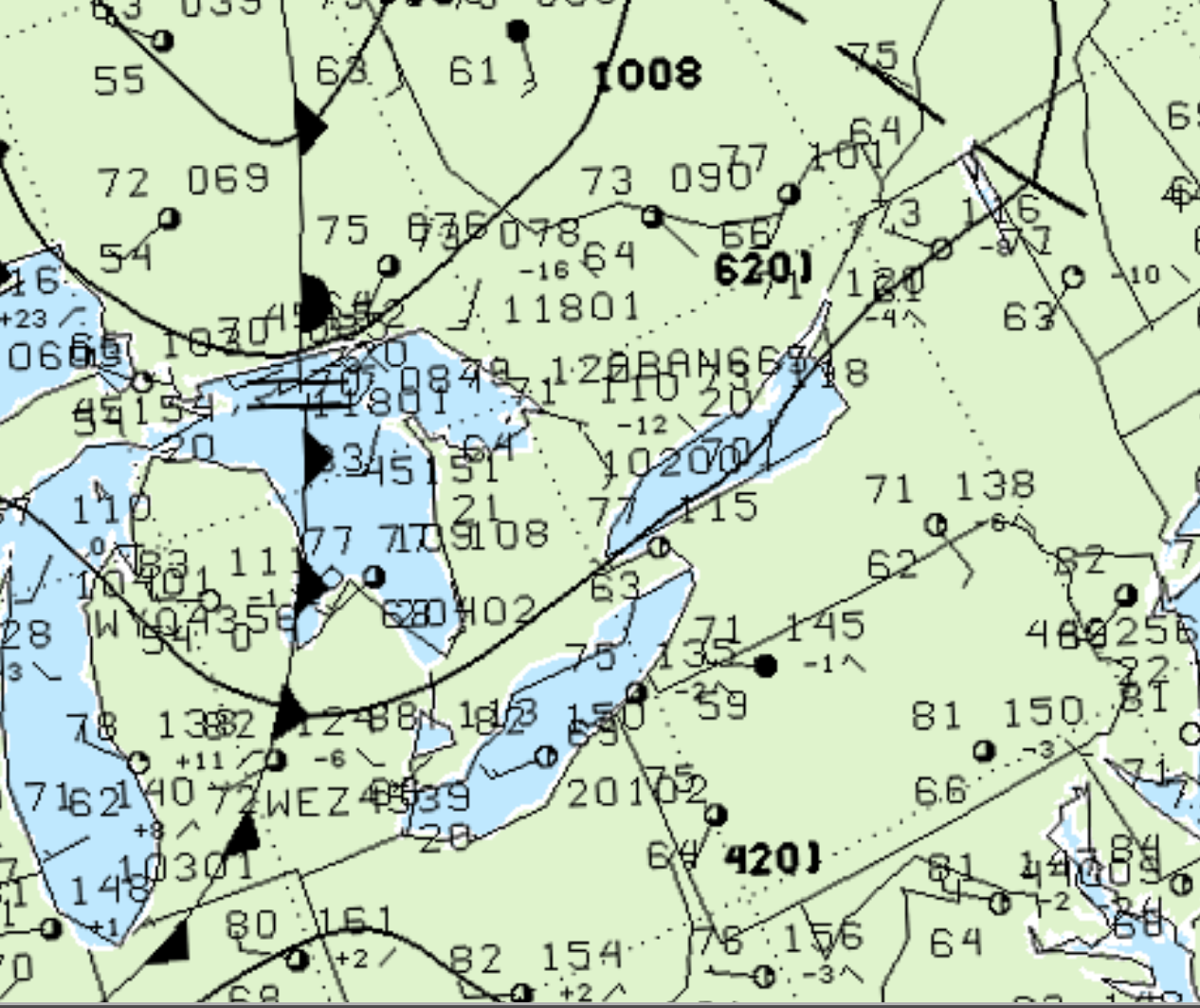
Ahead of the front, a very moist environment was present, with temperatures at 77F with a 63F dew point observed near Hamilton (Figure 1). As the cold front slowly moved east, strong forcing initiated thunderstorms across southwestern Ontario.
Figure 2 depicts the surface observations at 8:00 pm, which shows the cold front stalling on the shores of Lake Huron and a trough of low pressure over Toronto. Southerly winds blowing over Lake Erie activated lake-breezes, which enhanced low-level shear and forcing in the area.
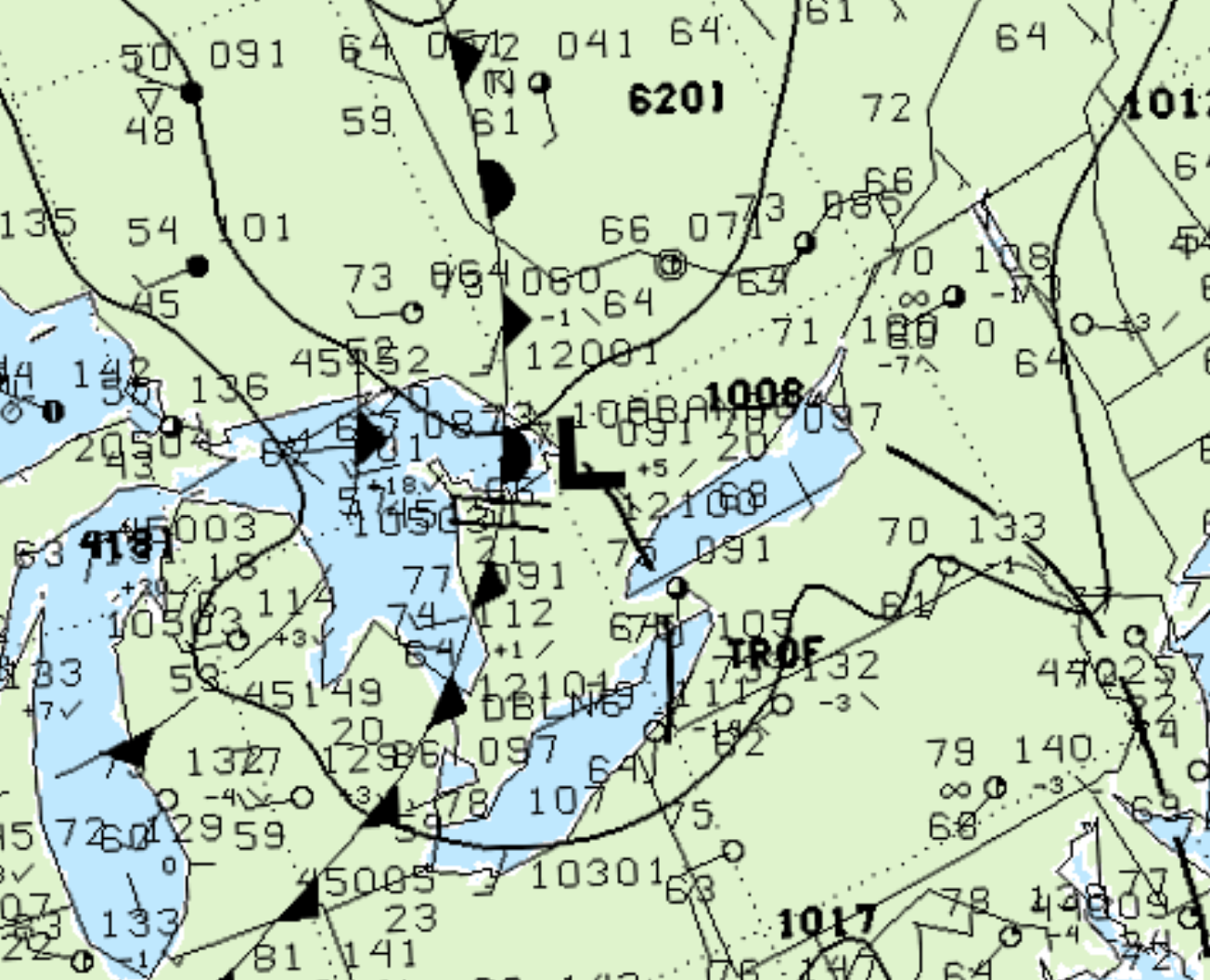
Figure 3 depicts the visible satellite imagery at 7:45 pm EDT, which shows several supercells occurring over Guelph and Toronto. Of note is a lake-breeze boundary oriented from southwest to northeast (circled in red) ‘feeding’ into the developing Guelph supercell (circled in blue). Five minutes later, the supercell would be depicting low-level rotation on Doppler radar (Figure 4).
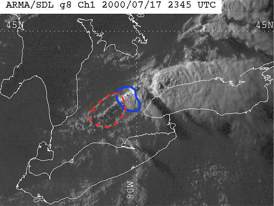
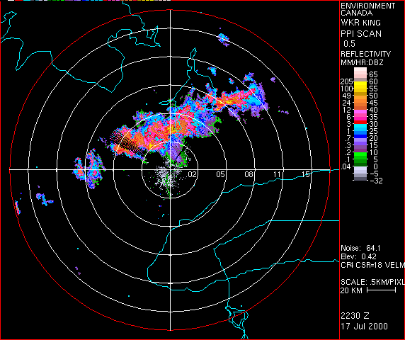
Figure 4 depicts the Doppler radar reflectivity from 2230Z to 0120Z (6:30 pm EDT to 9:20 pm EDT). This radar loop depicts a significant and classic ‘hook echo’ signature around 2350Z or 7:50 pm EDT on the Guelph supercell, which is the southernmost isolated storm. This hook echo manifests itself roughly 20 minutes prior to the tornado developing.
Summary
According to Environment and Climate Change Canada (2018), an F2 tornado touched down at 8:12 pm EDT in Guelph, ON. The tornado travelled for 13 km with a maximum width of 600 metres. The tornado caused no fatalities but caused one injury and $2 million dollars in property damage.
Sources
NWS Weather Prediction Center Surface Analysis Archive. (2017). Surface analysis 18Z Mon Jul 17 2000. Retrieved from: https://www.wpc.ncep.noaa.gov/archives/web_pages/sfc/sfc_archive.php
NWS Weather Prediction Center Surface Analysis Archive. (2017). Surface analysis 00Z Tue Jul 18 2000. Retrieved from: https://www.wpc.ncep.noaa.gov/archives/web_pages/sfc/sfc_archive.php
Sills, D. & Campbell, P. (2000). Storm Damage Survey – 17 July 2000. Retrieved from: http://www.yorku.ca/pat/research/dsills/surveys/17Jul00/Guelph/survey.html
Environment and Climate Change Canada Data. (2018). Canadian National Tornado Database: Verified Events (1980-2009) – Public. Retrieved from: http://donnees.ec.gc.ca/data/weather/products/canadian-national-tornado-database-verified-events-1980-2009-public/