Hardwick, MA EF1 Tornado of October 23, 2018


Figure 1 depicts the surface observations at 5:00 pm EDT, which shows an approaching cold front across the northeast United States. This front moved across Massachusetts in the early evening hours of October 23rd triggering thunderstorms, which ultimately led to this tornado.
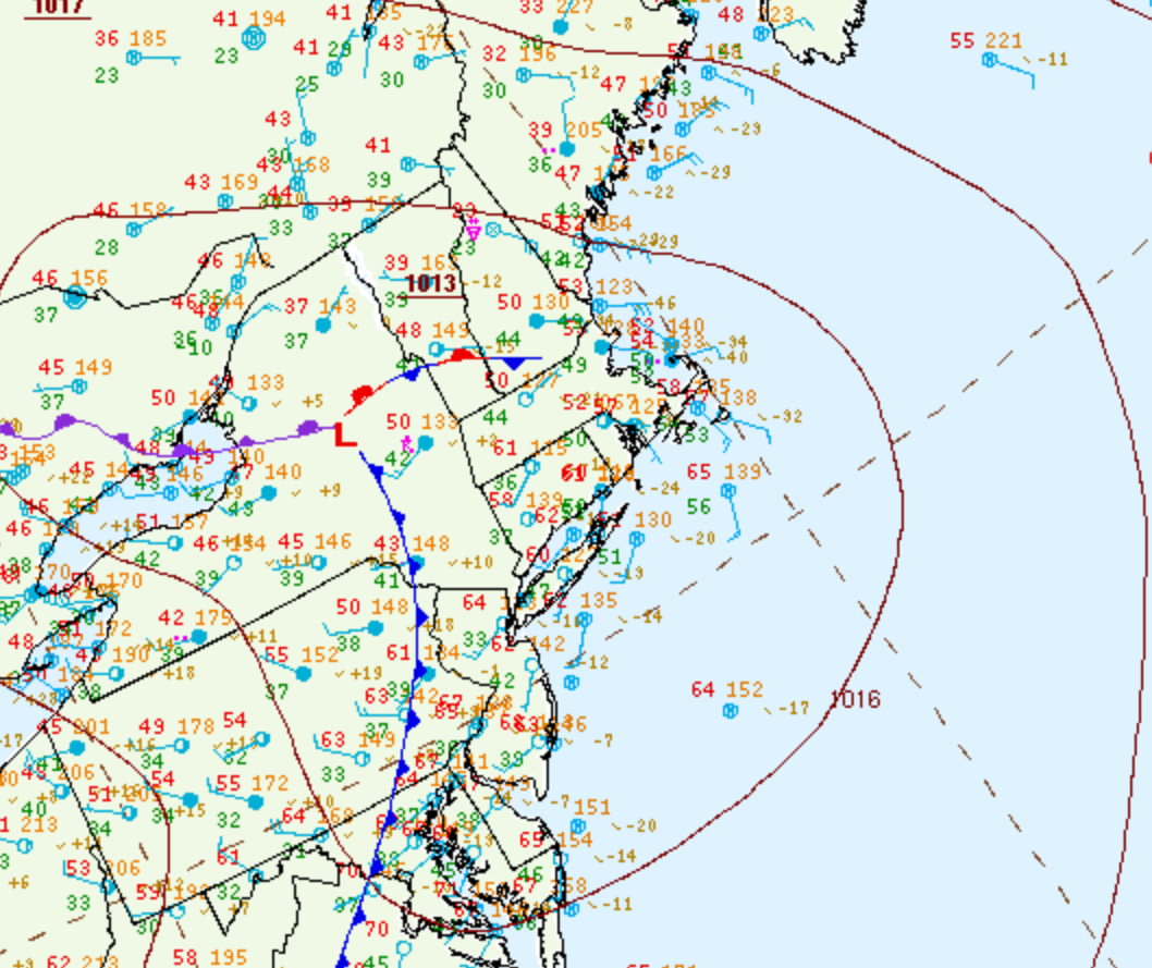
Figure 1. Surface analysis at 21Z on October 23, 2018 showing mean sea-level pressure (MSLP) contours, surface observations, fronts and pressure centers (WPC, 2017)

The Hardwick, MA EF1 tornado of October 23, 2018 impacted Worcester County in Massachusetts. According to NOAA (2020), the EF1 tornado caused no fatalities or injuries. The damage caused by this tornado was not documented by NOAA. The tornado touched down near Patrill Hollow Road at 4:03 pm EDT. The tornado travelled for 0.8 miles and had a maximum width of 350 yards.

Figure 2. Episode narrative for October 23, 2018 (NOAA NCEI, 2020).

Sources

NWS Weather Prediction Center Surface Analysis Archive. (2017). Surface analysis 21Z Tue Oct 23 2018. Retrieved from: https://www.wpc.ncep.noaa.gov/archives/web_pages/sfc/sfc_archive.php

NOAA National Centers for Environmental Information (2020). Storm Events Database. Retrieved from: https://www.ncdc.noaa.gov/stormevents/

National Centers for Environmental Information reports:

A tornado touched down south of the middle stretch of Patrill Hollow Road in Hardwick around 403 PM EDT. It then moved northeast, crossing the road and ended up in a wooded area to the northwest of the intersection of Patrill Hollow Road and Czesky Road, to the south of Greenwich Road. There were several eyewitnesses who saw the tornado. A school teacher at the Eagle Hill School saw it form, touch down, and lift just as quickly as it had touched down. Another person who was much closer to the circulation saw the swirling of debris. A third person heard a tremendous roaring sound. More than 150 trees, many of which were medium to large oaks, were either uprooted or snapped on Patrill Hollow Road. While most were blown down from southwest to northeast, the survey team did find several that were blown down from east to west, indicating rotation. Wind speeds were estimated at 90-95 mph, which is classified as EF-1 on the Enhanced Fujita Scale. Farther to the east, three very large trees were downed in the Old Cemetery near Hardwick Common. At an old abandoned gas station, shingles were missing and a metal cover to a pump was blown off. Next door, a cupola was blown off the roof of the fire department. It is believed that the wind damage there was from straight-line winds associated with the same storm cell, but not directly from the tornado.