
National Centers for Environmental Information reports:
![]()
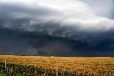
On 31 May, an intense, long-track tornado formed southwest of El Reno. This exceptionally wide tornado took a complex path, rapidly changing in both speed and direction. The tornado spared El Reno and its airport from a direct hit, tracking just south of those locations. The tornado damaged numerous homes along with a few businesses near El Reno. Additionally, intense sub-vortices destroyed crops in numerous fields in the area.
The tornado developed at 6:03 p.m. just northeast of the intersection of Heaston and Reuter roads. Initially, the tornado moved to the southeast at 20 to 25 mph. At 6:09 p.m., the tornado turned to the east, just south of Reno Road between Heaston and Brandley roads. The tornado continued to expand in size just southwest of the El Reno Municipal Air Park, where its speed increased to 30 to 40 mph. As the tornado passed just south of the airport, two satellite tornadoes formed briefly on the west side of the tornado.
At 6:19 p.m. the tornado crossed Highway 81 near Reno Road as it continued to expand in size. There, the tornado abruptly turned to the north, while also accelerating to greater than 50 mph. From 6:24 to 6:26 p.m., the tornado reached its maximum in size and intensity near the intersection of Radio and Reuter roads. The tornado, still very large, slowed down as it approached I-40. From 6:27 to 6:35 the tornado made a loop just north of the interstate while decelerating to less than 10 mph. After 6:35, the tornado moved east once again, and dissipated at 6:42 p.m. near the intersection of I-40 and Banner Road.| |Eight people were killed in the tornado, all in vehicles. This included three severe storm researchers who were killed east of US-81 as the tornado overtook their position. Additionally, several other people were killed while attempting to escape the tornado near Highway 81. Finally, two people were killed along I-40 while waiting for the storm to pass.
The monetary damages were estimated. This tornado was well sampled by two separate mobile research radar teams ��� the University of Oklahoma RaXPol radar, and the Center for Severe Weather Research���s Doppler on Wheels. Both radars captured high temporal and spatial resolution data relatively close to the large tornado. Both radars measured winds in the tornado of more than 200 mph. The RaXPol radar data shows winds of at least 295 mph very close to the surface. These intense winds were present in very small sub-vortices within the larger tornado circulation. An analysis of the high resolution radar data combined with the results of the ground damage survey indicates that none of these intense sub-vortices impacted any structures in rural Canadian County. So despite the measured wind speeds, surveyors could not find any damage that would support a rating higher than EF3 based solely on the damage indicators used with the EF scale.
The maximum tornado width was 2.6 miles. However, the damaging wind swath was much larger, as non-tornadic downdraft winds extended for at least a mile south of the tornado. Given the difficulty of separating this damage from tornadic damage, the OU RaXPol radar was used to help determine the width.