

Published on
In 2017, I drove my soft top convertible into Nebraska to storm chase for the first time in my life. I had moved to Minneapolis a few months before, so this was only a natural decision for me to make. Driving a soft top convertible around tornadic supercells isn’t exactly advice i’d be giving anyone else, but it was an amazing experience for me – and it is suffice to say that I have been itching to get back out there.
Since my first chase, I have been lucky enough to meet and interact with many folks who are extremely knowledgeable, and I am working each day to apply my meteorological ability and to learn more about how to chase these beautiful beasts. This year, I will be storm chasing for over a week. I am lucky enough to be bringing a DSLR camera with me, and recording video in 4k resolution. I’ll have the opportunity to produce video and photos that I hope will be extremely rewarding – and more importantly, I will have the opportunity to chase supercells for several days and document it all; a dream of mine since I was just a kid.
I’ll be chasing from May 25th to June 3rd 2018, and in the next few moments I’ll do my best to outline my research and thought process in determining where to set up “base camp” – as well as how I think the week (and season) will progress.
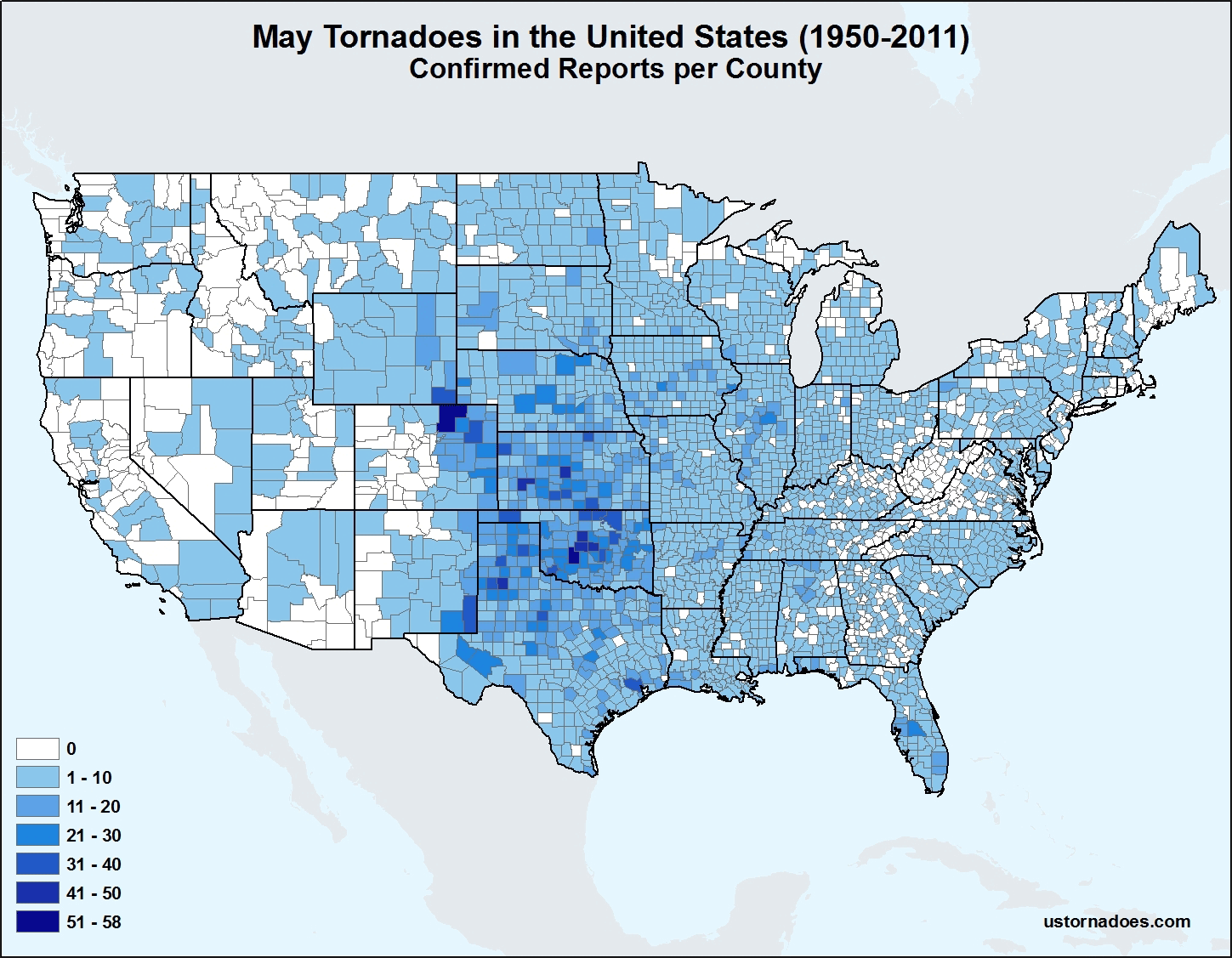
When it comes to monthly counts of tornadoes in the United States, May is superior, especially in Chase Alley. It is by far the most consistently active month when it comes to raw tornado activity numbers. This is a fairly well known fact among storm chasers. The peak of activity in May, according to most available data, occurs during the middle to latter half of the month. There are two semi-individual tornado-day peaks, one near May 20th and another near May 25th. (Note: the actual raw tornado day concentrations peak in June, but May features the most consistent activity).
The tornado day breakdown by county shows a clear weighting toward the South Central Plains. There is a specific lean toward Oklahoma and Kansas during the month. This should come as no surprise to storm chasers who have for years wandered around those lands and have come back with incredible photos and details of tornadoes there from Late April through May. With that being said, every year is different – and one of the most important pieces of this storm chasing experience for me will be researching where to be and when to be there.
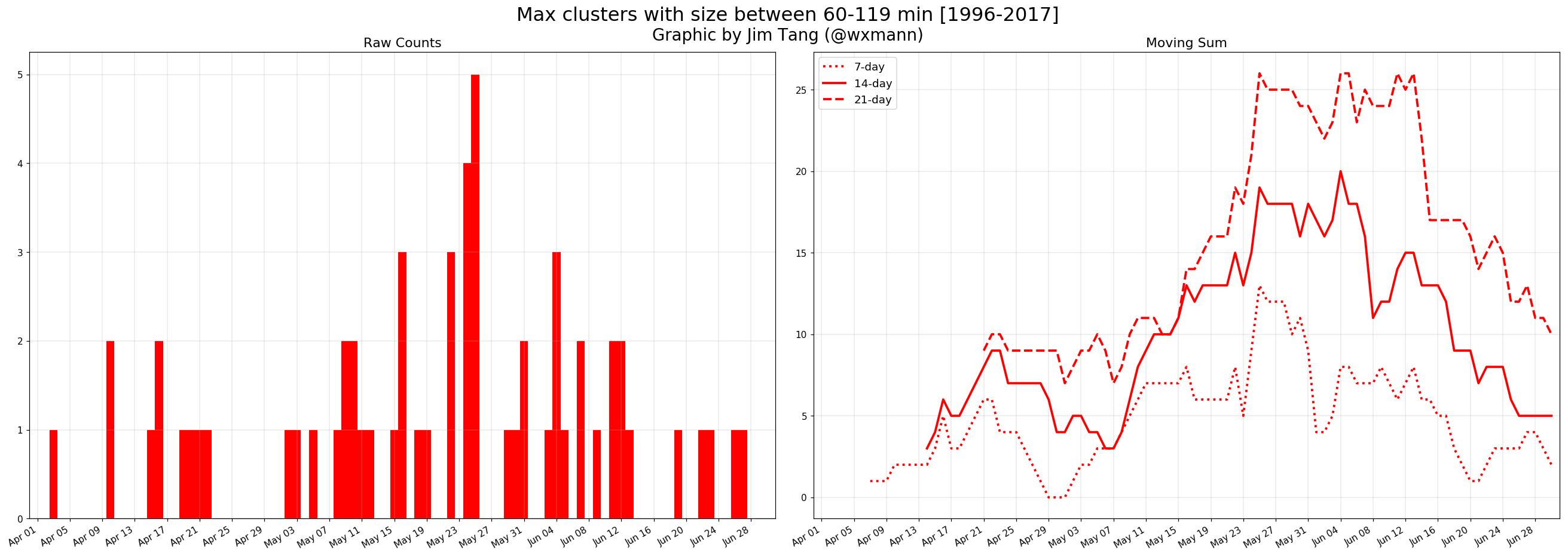
In addition to what we have already outlined above, there is some historical weighting of significant tornado events (or the biggest “clusters”) toward the late May period, which conveniently, and not coincidentally, falls right into our Chase Week from May 25 – June 3rd.
In fact, the clustering of larger events peaks almost directly within the period of time that we will be out chasing storms in late May. This can be visualized with Jim Tang’s awesome graphics attached below – we encourage that you read his article (published today) on US Tornadoes right here.
So what does all of this mean, really? In terms of sensible weather for this upcoming year, not much. But it does tell us that statistically and climatologically, the time of the year that we will be roaming the Great Plains gives us the best probabilities of any time of year to see a significant tornado event(s).
2017-2018 Winter Review | The more we change, the more we remain the same
The winter of 2018 was one of major fluctuations. This was true throughout the majority of the season. At the start, a period of large-scale Pacific high latitude blocking led to impressive cold flooding the United States. From late December through mid January, temperatures were well below normal across a large majority of the Northern 1/3 as a -EPO block dislodged polar air southward into Canada.
During the mid-winter months, a shift occurred where high latitude blocking took a prolonged hiatus. During late January and February the stratospheric polar vortex strengthened and a Pacific retrograde occurred – leading to higher than normal heights across the South/Central USA and Eastern USA. Temperatures moderated quite a bit across the country during this time and winter storms were much less frequent.
The final major change came in late February when a major stratospheric warming event occurred – sudden in nature – and completely disrupted the high latitude weather pattern. This was the first sudden stratospheric warming event of this nature and magnitude in almost a decade. Accordingly, a major -NAO blocking ridge developed, with statistical NAO values dropping below -5 standard deviations. High latitude blocking retrograded into the Central Canadian region and remains there as of this writing.
The Forecast Moving Forward
The proverbial paint from this SSW and blocking episode is still very much dripping throughout the hemispheric height pattern and wave guide. A Pacific wave break will regenerate high latitude blocking in the Pacific domain toward Alaska, with additional Central Canadian blocking likely to persist into early April. This suggests that the pattern will remain unfavorable for severe weather in the Central United States through at least April’s first week and quite possibly even into the middle of the month.
Tropical forcing remains a topic of major discussion as a notable warm pool continues to build. The SOI, however, remains indicative of La Nina conditions and eastward propagation of the warm pool remains in question with the MJO in flux. The Spring forecast barrier creates difficulty and using ENSO models won’t be very helpful during this time frame. My suspicion is that any transition to El Nino conditions will be too late to heavily affect this severe weather season, at least through the month of June.
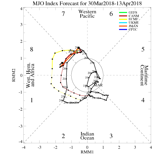
In the short term, there have been several studies published and several blogs/social media notes made regarding the upcoming shift towards an amplified Phase 2 MJO (Eric Webber, twitter, to name one). A fantastic study and paper was published recently that shows a clear correlation and rather astounding statistics linking Phase 2 MJO pulses with amplitude of 1 or greater and violent tornado outbreaks. For those of you venturing out in April – this is well worth the read. Stay up on your Indian Ocean convection forecasts and look for an opportunity for severe weather in the Southeast states or Arklatex around Aprils second week.
Analog years and their value moving forward
To help facilitate the forecasting process, we can us analog years from the past. In other words, we can take a look at years that featured similar base conditions hemispherically, and then narrow them down by which years had similar progressions throughout the winter and leading up to March and April.
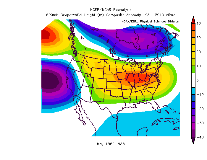
There are two standout analogs that we can use that make it through a filter of the current base conditions in terms of ENSO, high latitude winter conditions, and stratospheric evolution – 1962 and 1958. There are several others that are “close” 1954, 1956, 2001, 2006 to name a few. Utilizing individual analysis of these analog years in March brings particular interest to 1962 and 1958 – which featured similar stratospheric evolutions, high latitude blocking development, and Nor’Easter activity during the month of March (even around a similar time frame).
With this in mind, we can roll forward two different “sets” of analogs – the former two years weighted, and the other remaining “close” years rolled in to a composite as well. The results are quite interesting as the “close” years seem to diverge in terms of hemispheric wave patterns during Spring while the former two 1962 and 1958 have a pattern that is different than the others. In those two key years, the pattern takes on an entirely different look, with a classic Southwest US troughing anomaly and a building Central USA ridge.
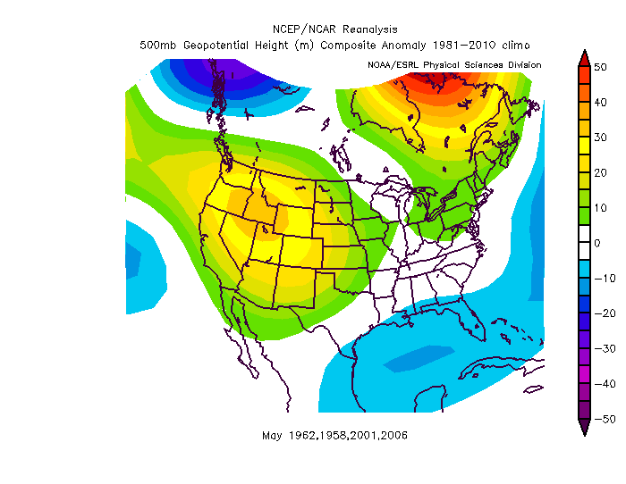
When rolling the other years in to the composite, the 500hpa geopotential height anomalies become less favorable from May into June, especially during June, when high latitude blocking returns and troughing becomes dominant over the Great Lakes region. This is an unfavorable pattern overall as a west-northwest flow would likely become the dominant average wind direction across the Plains during the month as a whole with those type of mid level height anomalies.
It is also interesting to note that the large majority of data is consistent in suggesting warmer than normal temperatures across the Great Plains during the month of May. Whether a Pacific jet extension or retraction of high latitude blocking is the culprit, the signal is consistent among all analogs – and noteworthy in its breadth.
Things change dramatically by June on all guidance, with an expansion of a Great Lakes trough anomaly and the return of high latitude blocking.
Analog summary and where we stand for now
It’s still quite early to be discussing overall target areas and thoughts – but the overall theme is that May 2018 looks likely to be a below normal tornado month. It doesn’t exactly help that a large ridge is signaled along the Western NHEM shores, but within the analog years discussed there are several that featured larger May severe weather events (1962 being one of them).
It’s important to remember, though, that analogs are only a small part of the package. For now, they provide a nice base idea in terms of how things could possibly evolve. Over the next few weeks, we will have to weight them properly based on analysis and observations of the hemisphere as a whole.
Too long; didn’t read?
- I’m storm chasing again, but this time for several days and with a good camera, from 5/25-6/3
- Analysis and analogs for the year so far bring us to 1962 and 1958 analogs as front-runners
- May analogs are not overly favorable but some of the “better” analogs have a very good composite height anomaly look
- June looks awful
There is much more research to come over the coming days and weeks as we slowly step closer to Chase Week. More than anything I am grateful for the opportunity to get out there and experience this – it is going to be amazing, and I can’t wait to capture it all.
As cited in the article, some graphics and imagery in this post were obtained from USTornadoes.com and Jim Tang.
Community Comments
There are no comments on this post
Want to leave a comment? Join our community → OR Login →