
National Centers for Environmental Information reports:
![]()
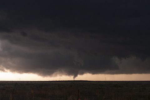
A large multi-vortex tornado developed in far north-central Motley County at 2033 CST. This tornado was nearly stationary at first, before drifting slowly north followed by an abrupt acceleration to the northwest into Hall County (continued below). Several storm spotters observed this tornado and debris cloud as it crossed Farm-to-Market Road 656. This tornado tracked over open ranch and canyon lands resulting in very few damage indicators. A limited road network and flooded roads prevented a post-storm ground survey conducted by National Weather Service meteorologists from assessing damage. Therefore, the tornado was given a rating of EF-unknown while in Motley County.
This is the continuation path of the tornado that began in northern Motley County. A significant tornado tracked northwest across rural southwest Hall County before narrowing and later dissipating about 1.5 miles east of Turkey at 2106 CST. Storm spotters indicated this large tornado was rain wrapped as it approached Turkey.
A NWS storm damage survey rated this tornado as EF-3. Although damage indicators were sparse in this part of Hall County, the wind estimate was derived from several steel pylons supporting electrical lines that were bent to the ground from winds estimated in the range of 135 to 140 mph. Additionally, there were trees blown over and uprooted as viewed from a distance along the nearest roadway. However, the survey team was unable to survey this damage due to flooded roads and a limited road network.
The development of this tornado and its unusual northwest motion were likely the result of a northward-moving outflow boundary tied to a left moving supercell that earlier impacted Matador (Motley County). Radar data indicate tornadogenesis occurred shortly after this outflow boundary impinged on the supercell.