
National Centers for Environmental Information reports:
![]()
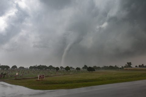
A highly visible tornado developed about 8 miles southwest of Mangum, then moved northeast through the northwestern and northern portions of Mangum before dissipating about 3.5 miles north of Mangum just east of Oklahoma Highway 34. The beginning of the tornado path was in rural areas and the valley and terrain around the Salt Fork of the Red River and damage was mainly to trees. However as the tornado moved through the northwest side of Mangum and adjacent areas, many outbuildings were destroyed and at least one home just northwest of town had much of it's roof removed. The maximum damage in and near Mangum was consistent with an EF2 rating, although many indications (including research radar data from the Center for Severe Weather Research) indicate that the tornado was likely stronger in the rural areas southwest of Mangum.