

Published on
Tornado outbreaks just “feel” different than other chase days. You wake up and notice a distinct difference when you walk outside — the air is virtually dripping. There’s a constant breeze. It even smells different, although I’m not quite sure I can put my finger on what that’s about. Could be a little placebo effect, but I choose to believe its not. I’ve experienced this on a few occasions; May 24th, 2011 and May 31st, 2013 immediately come to mind. In the latter of the two, “the feel” was absolutely undeniable.
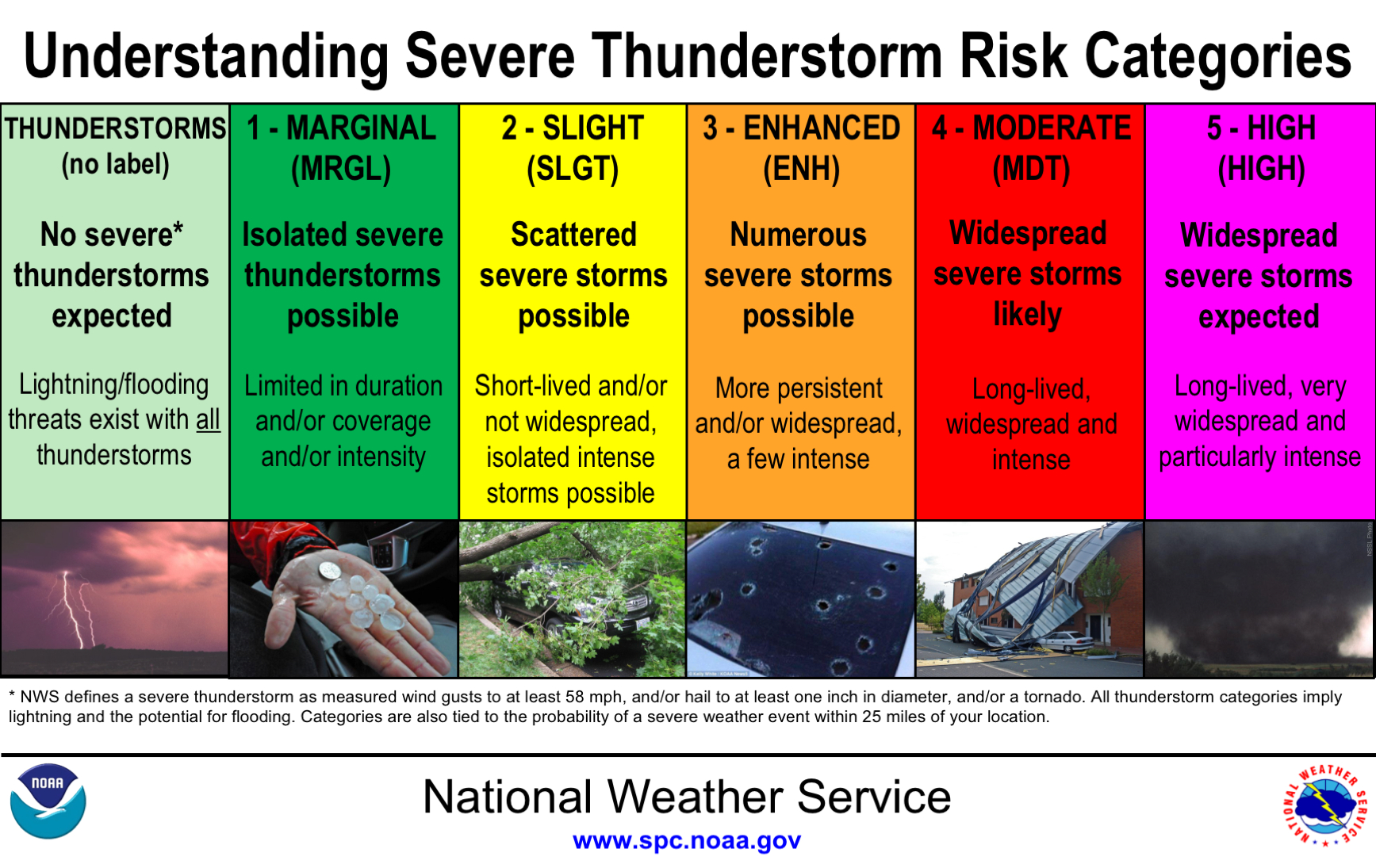
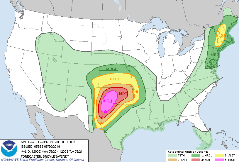
Some of “the feel” is undoubtedly related to the hype that comes with high-end tornado events. They (generally) don’t just pop up out of nowhere, and with the rise of social media consequent with the popularization of storm chasing as a quasi-mainstream hobby, no big day goes unnoticed in the days leading up. But when it ultimately comes down to it, there’s nothing that hypes up storm chasers like when a high-end convective outlook is issued by the Storm Prediction Center (SPC). There are five levels of severe weather risk issued by the SPC, the details of which can be seen below.
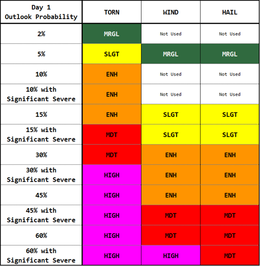
At least when I’m chasing (and often when I’m not), I stay up the night before to see the new day one outlook, issued at 1 am central time. For me, there is no better tornado chasing than in an enhanced risk characterized by a 10% hatched tornado probability. But there is nothing that gets chasers’ blood flowing like seeing the issuance of a high risk for tornadoes. High risks are tremendously rare — I’ve only chased three in my life; May 24th and 25th, 2011 and now, May 20th, 2019. May 24th, 2011 featured an ultra, ultra rare 45% hatched probability for tornadoes that lived up to its potential by producing several long-track, violent tornadoes. Even considering that event, May 20th, 2019 seemed like a different animal altogether. Two days prior on May 18th, the SPC issued a relatively rare Day three moderate risk, and re-upped the moderate risk the following day.
While the threat level was obviously apparent given the impressive parameters modeled to be in place over the moderate risk area, the excitement began to truly build in earnest when the extended range High Resolution Rapid Refresh (HRRR) model showed a 36-hour forecast that featured what seemed like an army of likely tornadic supercell thunderstorms in a nearly pristine thermodynamic and kinematic environment. The event highly resembled, at least in HRRR model space, high-impact Dixie Alley events where strong to violent tornadoes are more common than anywhere else in the world.
Now a quick scientific opinion: to me, every weather forecast should be formulated and communicated probabilistically using multiple models and model runs (re: ensemble models) in order to best understand the full spectrum of possible outcomes that a particular event might span. That’s why a single HRRR forecast, especially one in which a forecast is largely composed of something such as simulated radar (which is not a good way to forecast anyway), should be taken with several grains of salt. As May 19th rolled on however, subsequent model runs across multiple high-resolution modeling platforms began to show considerable inter- and intra-model consistency in a solution similar to that initial HRRR forecast. It was really starting to get real.
As we had seen a few great tornadoes a couple days earlier on May 17th, we needed to celebrate with a storm chasing tradition: a steak dinner. That meant we needed to go to The Big Texan in Amarillo, which seemed like a good place to post up for the evening. After dinner, I did some in depth model analysis and some of what I saw was eye-popping; extreme instability coupled with incredible shear created a parameter space on par with or perhaps exceeding any of the biggest outbreaks in recorded history. And sure enough, the army of supercells remained in the simulated reflectivity fields. While the rest of my chase group went to sleep, I stayed up until the new SPC day one outlook. Right on the dot at 1 am, they did it: a high risk with some of the most aggressive and serious wording I’d ever seen. The forecast seemed spot on.
As the mid-level jet ejects northeastward across the southern High Plains this afternoon and evening, a tornado outbreak is likely across the southern Plains. The tornado outbreak is expected to continue into the overnight period. This event should result in a significant threat to life and property.
Excerpt from the May 20th, 2019 SPC 12z day one outlook, featuring some of the strongest wording I’ve ever read in an outlook.
The next morning I woke up and met up with my chase partners. There was an electricity — a nervousness — that only comes with a truly high-end severe weather day. We started making our way south towards Childress, Texas with the expectation that storms would develop and become tornadic by mid-morning — a truly rare event in and of itself. Elevated storms north of the warm-front were occurring during most of our drive from Amarillo to Childress and largely precluded “the feel”. Upon making it to Childress, we noticed something odd; the tornadic mid-morning storms hadn’t developed. We knew all along that these storms wouldn’t be the real show, so we didn’t worry too much. We grabbed some breakfast at Sonic and watched out the window as the high clouds in the wake of the storms to the north began to burn off. Upon walking out, something became obvious: It was sticky, breezy and warm. It had the smell. It had “the feel”. I was excited.
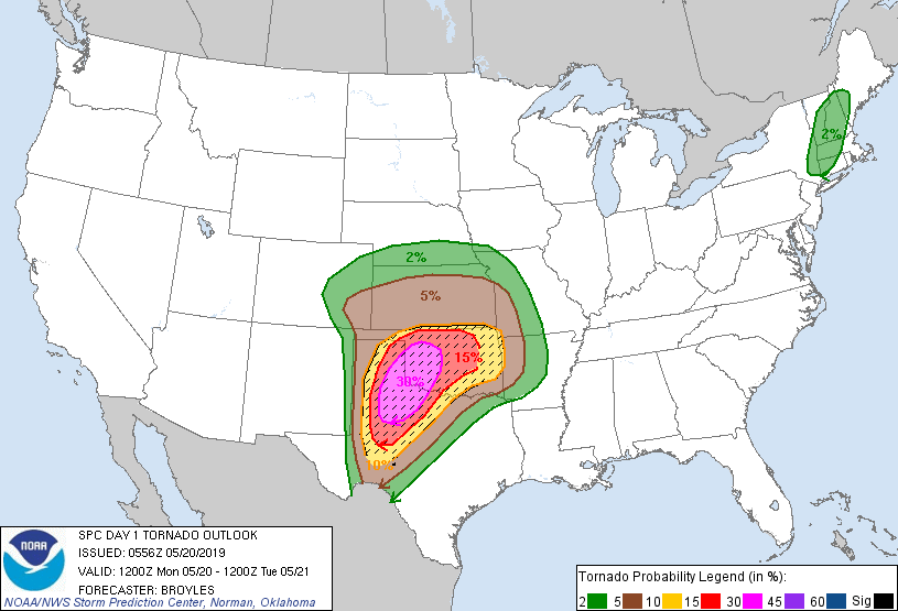
We sat in Childress for a couple more hours, waiting to see what the new SPC day one outlook set to come out at 1130 am would show us. What came out next blew us away: 45% hatched tornado probability from the Texas Panhandle extending east into Oklahoma. Just the fourth time in history a 45% probability had been issued and the wording in the discussion was terrifying. An outbreak of Violent tornadoes was expected.
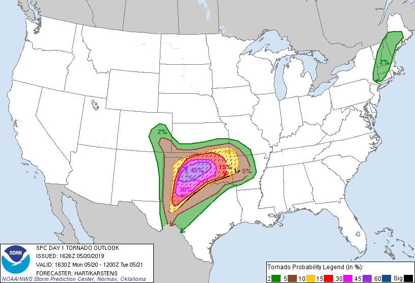
An outbreak of tornadoes, some potentially long-track and violent, is expected today into this evening over portions of northwest Texas into western and central Oklahoma.
Excerpt from the May 20th, 2019 SPC 1630z day one outlook
As if this wasn’t enough, the SPC soon issued its first watch for right where we were sitting. The tornado probabilities on the watch were astounding: greater than 95% chance of two or more tornadoes; 90% chance of one EF2+ tornado. This was the highest probability watch I’d ever been in, let alone chased. Not long thereafter, they outdid even that: a second watch east of the first one featuring maxed out, greater than 95% probabilities for every single watch criterion. They had only issued a watch like this once before, and it came on the day of the April 27th, 2011 super outbreak in Dixie Alley — the largest tornado outbreak in history.
It wasn’t long before storms began developing to our southwest. While waiting for them to mature a bit, we decided to drift a bit east towards Hollis, Oklahoma in order to give ourselves a bit of breathing room once they started rocketing towards us as fully developed, tornadic supercells. Realizing quickly that storms weren’t moving nearly as fast as expected, we shot back south towards Childress. What a silly, unforced error. We got south and ahead of a tornado warned storm near Paducah, Texas just as the first of what we expected to be multiple tornadoes touched down. We got into the hook of the storm and looked back at the mesocyclone south of Kirkland, Texas — a spot that should’ve provided us with a perfect view of the tornado. Alas, we couldn’t see a thing through a haze so dense that visibility was seemingly reduced to a hundred yards. Around the same time, the storm inexplicably began to shrivel up. We were flabbergasted, as it was in theoretically the best environment for the genesis of violent tornadoes the planet had seen in many years. It just didn’t make sense. Even so, the storm remained discrete and we just couldn’t leave it in favor of other storms when it was in that environment.
Perhaps even more curiously however, many of the storms that had developed along the dryline to our west were beginning to cluster together rather than remaining largely discrete as indicated by the models. Considering that this was now occurring after the morning storms depicted in the models failed to develop, we started to worry that perhaps something was occurring in the atmosphere that the models didn’t pick up on. Even our storm seemed to be attached at the hip to another storm on its northeastern flank — never a good sign. As the storm continued tracking to the northeast, we had a choice to make in order to keep up with it: we could either go north then east or take a little more time and go east then north. We decided on the latter, as the storm wasn’t looking imminently tornadic and we felt that this strategy would give us the best opportunity to stay ahead of the storm should a strong mesocyclone develop and cause the storm to deviate to the right. Sure enough, this decision and perhaps this decision alone proved the best one we’d make all day. As we began the trek to get back in front, the storm began to pulse upward and the rotation began to tighten — there was hope.
We finally got back on the storm in between East Duke and Mangum, Oklahoma. We were confused by the (relative) dearth of storm chasers in front of us. Thousands of people were out chasing that day, and yet it appeared that very few were in a similar position to ours. It was at this point we realized that most had made the choice to go north then east and were now behind the storm which had begun to deviate to the right. As the circulation was set to pass about a mile in front of us, we stopped on a hill to get a view of a rapidly rotating wall cloud complete with a strong rear-flank downdraft wrapping around it. Just as the motion was starting to become rather impressive, we realized we had to move to avoid being outflanked. With relative ease considering the number of chasers we expected to see, we made it back out onto the main road. We turned on the radio to listen to local reports that were coming through. Sure enough, a chopper was reporting a large, multi-vortex tornado on the ground not a mile from our location. We were confused, as we didn’t have a visual of a ground circulation even given our ability to see the rapidly rotating wall cloud just to our west. After what seemed like an eternity, we started to see something emerge and come towards us — a large, strong to violent multiple-vortex, white stovepipe tornado — and it was close.
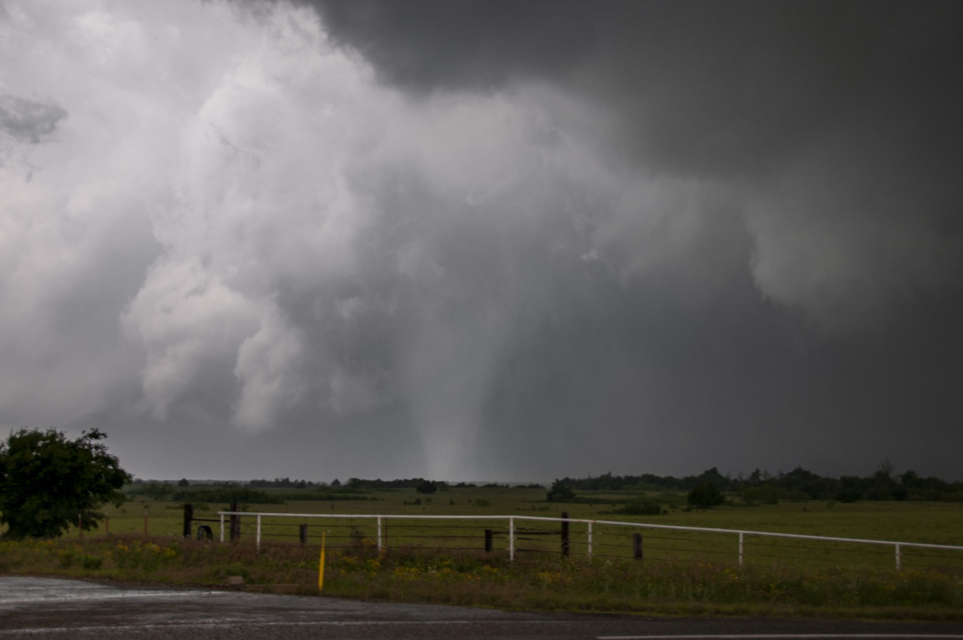
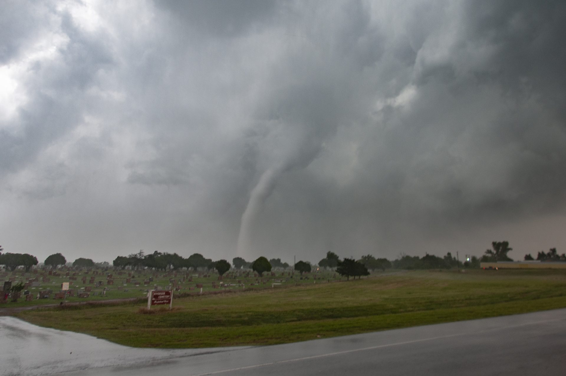
As the circulation approached our position, the road turned parallel to its track, allowing us a perfect view of the incredible tornado. The strong RFD had eroded the back of the updraft just above the tornado, illuminating it and allowing us to see the multiple vortices dancing around the base, rising and sinking before disappearing and being replaced by the one next in line. Given the relatively quick storm motion and the now lengthening line of chasers behind us, we were only able to stop for 30 seconds or so at a time to take photos. Further complicating things, each time we’d stop the RFD would blast us with strong wind and heavy rain. We continued on into Mangum as the tornado began to rope out in the form of a tall elephant trunk. Fortunately, it appeared at this point that the tornado had mostly missed town.
Not long after making our way into and out of town, the tornado dissipated as we continued to move east. At this point, we assumed that the storm would recycle and produce another, larger tornado. It was in an incredible environment after all. Curiously enough though, another storm had developed on its western flank, similar to what this storm had done to a storm to its east earlier in the day. We got well out ahead of the circulation and stopped to get out of the car and watch it approach. After a few minutes, a strong burst of cold air hit us — outflow from the new western storm. At that moment, we knew the day was done. Sure enough, the storm to the west seeded our storm and undercut it with outflow. Not long after, the western storm was undercut by outflow from storms to its west too — the chase was over at 6:30 pm on a high risk day. Even having seen a significant tornado only moments before, this seemed incomprehensible.
I won’t delve too deeply into the meteorology behind the event, but it largely busted. There are multiple theories as to what happened, some that I agree with more than others. Rather than discussing that, lets talk a little about how we did. First and foremost, I’m so, so proud of how we navigated around the storm. The decision to move east then north in order to catch the tornado between East Duke and Mangum proved to be tactically perfect. Some of the images of chaser traffic behind us are mind blowing. There was even a car accident between some chasers as traffic grinded to a near halt. We managed to stay ahead of that and get a beautiful view of a gorgeous white tornado. The tornado itself was examined by multiple mobile dopplers, each measuring extremely strong rotational velocities in the tornado just above the surface. Aerial photos in the wake of the tornado showed moderate structural damage as well as a distinct ground scar — indicative of a significant tornado.
All in all, the day underperformed breathtakingly — and that’s a good thing. Even as a storm chaser who actively wants to see high-end tornadoes, a day like May 20th, 2019 not living up to its expectations is a blessing. Much of the Texas Panhandle and nearly all of Oklahoma dodged a serious bullet. There was a real possibility that many lives could have been lost or permanently altered by the weather that day, but that simply didn’t happen. For that we should all be thankful — even us storm chasers who want nothing more than to chase on a day with “the feel”.
Community Comments
There are no comments on this post
Want to leave a comment? Join our community → OR Login →