

Published on
Prologue: In 2008, I was fortunate enough to be experience Hurricane Ike first hand. Ike was my first hurricane, and I was (of course) quickly hooked on the rush. Unfortunately for me (and very fortunately for the rest of the United States), landfalling major hurricanes went virtually extinct after Ike, making another substantial encounter impossible. That would all change in late August 2017 however, when a disorganized tropical wave began to make its way west across the Atlantic before turning north as it approached the Mexican coast. This wave would traverse the Yucatan, with models showing a rapid intensification into what would become Hurricane Harvey. Not one to miss an opportunity we’d been waiting years for, my chase partner Adam and I made plans to make the trip to the Texas coast. With my (University of Wisconsin) Morgan research group-mate Zoe in tow, we did just that. The following is a recounting of the experience that I wrote upon our return to Madison a few days later.
Left Madison this past Thursday around 10am and headed to Kansas City to meet up with Adam. We got to KC and immediately headed south towards Ardmore, Oklahoma, our stopping point for the night. With each passing model run, we got increasingly excited about the possibility of a major hurricane making landfall in an area that was accessible to us. As we drove, we continuously kept tabs on the progress of Harvey, watching intently as the storm began to rapidly intensify, as was evidenced by both radar and GOES-16 satellite imagery. The latter btw, is an incredible tool. For anyone who hasn’t seen the half-kilometer 30 second and 5 minute imagery of this cyclone as it began to intensify, I’d highly suggest doing so. Seemingly with each passing minute, the storm would increase its symmetry and intensity, becoming a strong category 2 hurricane as it slowly approached the Texas coast. We made it to Ardmore around 1:30am to get a few hours of sleep before driving eight more hours the following day to the coast.
We woke up Friday morning to one of the more intense looking Atlantic basin tropical cyclones I’ve seen. This storm was the thing of textbooks. As we drove south, the storm continued to intensify, and finally reached category 3 “major” hurricane status in the mid-afternoon. We began to fear the storm was going to make landfall before we would make it to a position to experience it, but luckily for us (and perhaps very unfortunately for the Texas coast), it slowed down a bit and remained over water for several more hours. In doing so, the storm was able to intensify to category 4 status. Originally, we’d planned to intercept the storm in Rockport, TX, but due to flooding concerns, we decided to stay about 15-20 miles further inland, and took shelter at a small carwash in Refugio, TX. Around this time, some of the outer rainbands were coming ashore, and we started getting pretty significant wind gusts. I became rather uncomfortable with our chosen shelter, due not only to its proximity to power lines but also its less than stellar construction. We ventured out and looked for a better shelter, eventually finding a more substantial, totally enclosed brick carwash a few blocks down.
As the storm began to come closer to shore, the winds picked up rather significantly, and we started getting sustained winds near hurricane force (>74 mph) and gusts much higher. All of a sudden, a transformer probably 25 feet in front of us arced, causing us to lose and then quickly regain power. At this time, Zoe, Adam and myself were standing in the carwash outside of our car. From seemingly out of nowhere, we heard “Car wash sequence initiated”, as the car wash began to power cycle and the brushes began to get into position to begin the wash process. We all rushed into the car, only to have the car wash stop before it could start. This sequence actually happened a few times as the power surged.
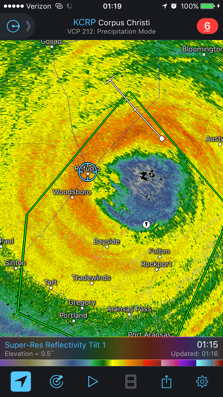
Around this time, the eye wall (area of most significant wind) officially came ashore in Rockport, doing some pretty extreme damage to many of the structures in that town. Given that the storm had virtually stalled, we were still a couple of hours from the true eye wall but began to get really significant gusts of wind. I heard a large bang and turned around to notice that an iron sign that had been hanging in the entrance to the car wash had become detached and was hanging from just one of the chains it was on. I got out to inspect it to notice that the roof of the carwash was beginning to collapse. We fled the car wash in time and took shelter on the leeward side of a McDonalds, which was in a large, very well constructed brick building. This would be where we rode out the true eye wall, and it provided us with exceptional shelter from the wind and rain. It was so good in fact, we were able to get out of the car for a few minutes and experience the eye wall of a category 4 hurricane outside. I won’t soon forget this.
After about an hour or so of eye wall fury, we began to get into the eye. The storm however was beginning to wobble north, meaning our time in the eye was going to be limited. Unfortunately due to debris blocking our way, we were unable to get to a position quickly enough to look up and see the stars in the eye that some other chasers reported/got pics of. This is something that I will always slightly regret.
Around this time, we started to explore town to see utter destruction. Gas station awnings down, tree and sheet metal debris littering the streets, and the roof of our first car wash completely collapsed. We also quickly realized that the main road going in both directions was blocked and we were stuck in Refugio. This fact scared us tremendously, as many of the forecasts originally stalled the hurricane closer to where we were than Houston, where it ultimately stalled. The idea of 25 inches of rain in a town filled with downed power lines and debris didn’t exactly tickle our fancy, so we managed to find a way out of town and drove SLOWLY back out of the core of the Hurricane, passing through the (weaker) southwest eyewall back towards Sinton, Tx and ultimately on to San Antonio. At around 5am we made it to our hotel and slept until 11:30. The (hurricane) chase was over.
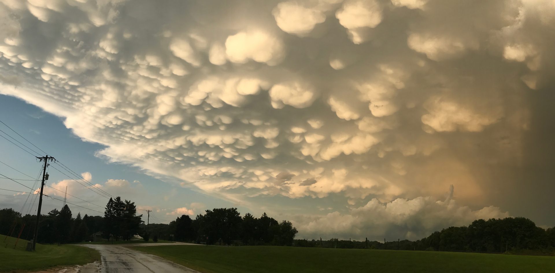
After a quick pitstop back in Kansas City, Zoe and I made our way back to Madison. Appropriately enough, immediately after crossing the border into Wisconsin a decaying thunderstorm treated us to the single most beautiful display of mammatus clouds I’ve ever seen. It was a fitting way to end the trip and a perfect example of mother nature showing us that even hours after being at her most violent, she will always be beautiful.
All in all, this was one of if not the most exhilarating, terrifying and worthwhile storm chases of my life. Hurricane Harvey snapped a 12 year major hurricane US landfall drought, and was only the fourth cat 4+ hurricane to make landfall in the US since 1970. To be able to say I was there is something I’ll never forget. I’ve always had a very healthy respect for Mother Nature, and yet she still managed to humble me. I think, at least for now, my hurricane chasing days are over. But then again, ask me when the next cat 3+ looks to make landfall.
Community Comments
There are no comments on this post
Want to leave a comment? Join our community → OR Login →