

Published on
Anyone who has ever chased with me knows just how much I despise chasing in Nebraska. Between the most spectacular bust I’ve ever experienced (non-human error division), missing huge events by a couple of days (re: Pilger) and the Sand Hills, Nebraska just isn’t my kinda place. You can probably imagine my dismay (horror) upon coming to the realization that Nebraska was probably going to be the play on the first day of my 2019 chasecation. This wasn’t how I wanted it to start.
But before we get into the chase, lets backtrack a bit. Over the last couple of years, my personal storm chasing luck hasn’t exactly been great. Since seeing the tornado festival at Dodge City in 2016, the only extended stretch I chased came in June of 2017 with Travis, Mike and my dad. Although we were fortunate enough to witness some great supercells on a nearly daily basis, we largely went tornado-less. The following year marked the first year since 2006 in which my father and I didn’t chase a single storm together, owing both to having to spend the spring and summer writing my Ph.D. disseration as well as a mostly unfavorable large-scale pattern. Needless to say, I really wanted to score big in 2019.
As of late April 2019, my dad and I didn’t have formal plans for a chase. There were hints in the long-range pattern as far back as January and February that May would be active tornado-wise, but making firm plans was difficult due to some factors out of our control. By early May however, it became very evident that the third and fourth weeks of the month were going to rock and roll. We decided to pull the trigger and planned to meet up with my partners Adam and Kevin starting on May 17th.
In the week leading up to the chase, many of the models started to show a pattern more active than I can really ever remember. Day after day of significant severe weather events, one seemingly bigger than the last. To say we were ecstatic was an understatement; we haven’t had a pattern that rivaled what the models were depicting in many years. Though as if on cue, two days before we were set to take off the models took a nose-dive. All of the deterministic model runs were showing sweeping, high-amplitude mid- and upper-level troughs digging deep into the southwestern United States: a recipe for messy storms and flooding rain. Myself, Adam and Kevin were nervous but decided that even given what seemed like a relatively unfortunate flow pattern, it would be foolish to pass up multiple forecasted troughs overlaying great moisture at the climatological peak of tornado season. We also remained encouraged that the ensemble model runs showed a lower-amplitude, flow configuration more favorable for severe weather. Once again as if on cue, the evening before we were all set to leave, the deterministic models began to retreat back towards the ensemble solutions. Hope sprung eternal once again as run after subsequent run shifted further and further back towards a favorable pattern.
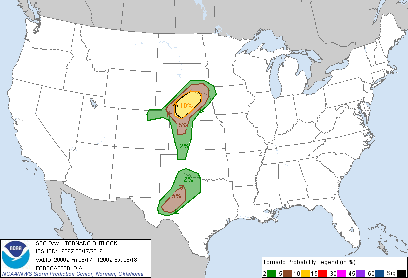
The first day of the chase looked big. A stout, perfectly oriented dryline was in place from South Texas north to a warm-front intersection composing a triple-point near McCook, Nebraska. To the east of the dryline, mid-60’s dewpoints helped foster strong destabilization underneath a screaming mid-level jet out of the southwest. Low-level flow was strong and out of the southeast, allowing for ample directional shear over virtually the entirety of the western portion of tornado alley. The stage appeared set. There was however, one fly in the ointment: the cap. Most convection allowing models failed to break out any precipitation within our preferred target region, the Texas Panhandle up through southwest Kansas. I was confident that this was likely a byproduct of some parameterization schemes found within the models, but was weary of testing out that hypothesis when southwestern Nebraska seemed primed for tornadic storms. This however lead me to an less than pleasing realization: Nebraska. Unfortunately (or as we later found out, very fortunately) we couldn’t pass it up; Nebraska it was.
We found ourselves in McCook, Nebraska in the early afternoon. To be honest, the ambient environment didn’t seem too appealing to the naked eye; it was relatively cool and cloudy. Stable. We got lunch and explored the local Walmart. We tortured ourselves as the HRRR model flip-flopped between favorable solutions and not-so-favorable ones. Finally after a few hours of waiting, the first echos began to go up to our south near Goodland, Kansas. We tracked down about 50 miles south and caught a developing supercell. After pulsing for about an hour, it began to get itself together and head right for, you guessed it, McCook. Within a pretty awful road network we jockeyed for position with the storm before ultimately getting out in front of it just as we re-entered town. By this point, the storm was tornado-warned with multiple rotating wall-clouds having been reported. We pulled back into one of the parking lots we had spent some time in a few hours earlier and were treated to some gorgeous supercell structure, complete with one of the more dramatic rear flank downdraft (RFD) cuts I’ve ever seen on a storm. The wall cloud just to its right was ragged but displayed moderate rotation and vertical motion on its edges. Nothing looked imminent, so we decided to move a little bit east in order to stay ahead of the storm. This decision almost proved very costly.
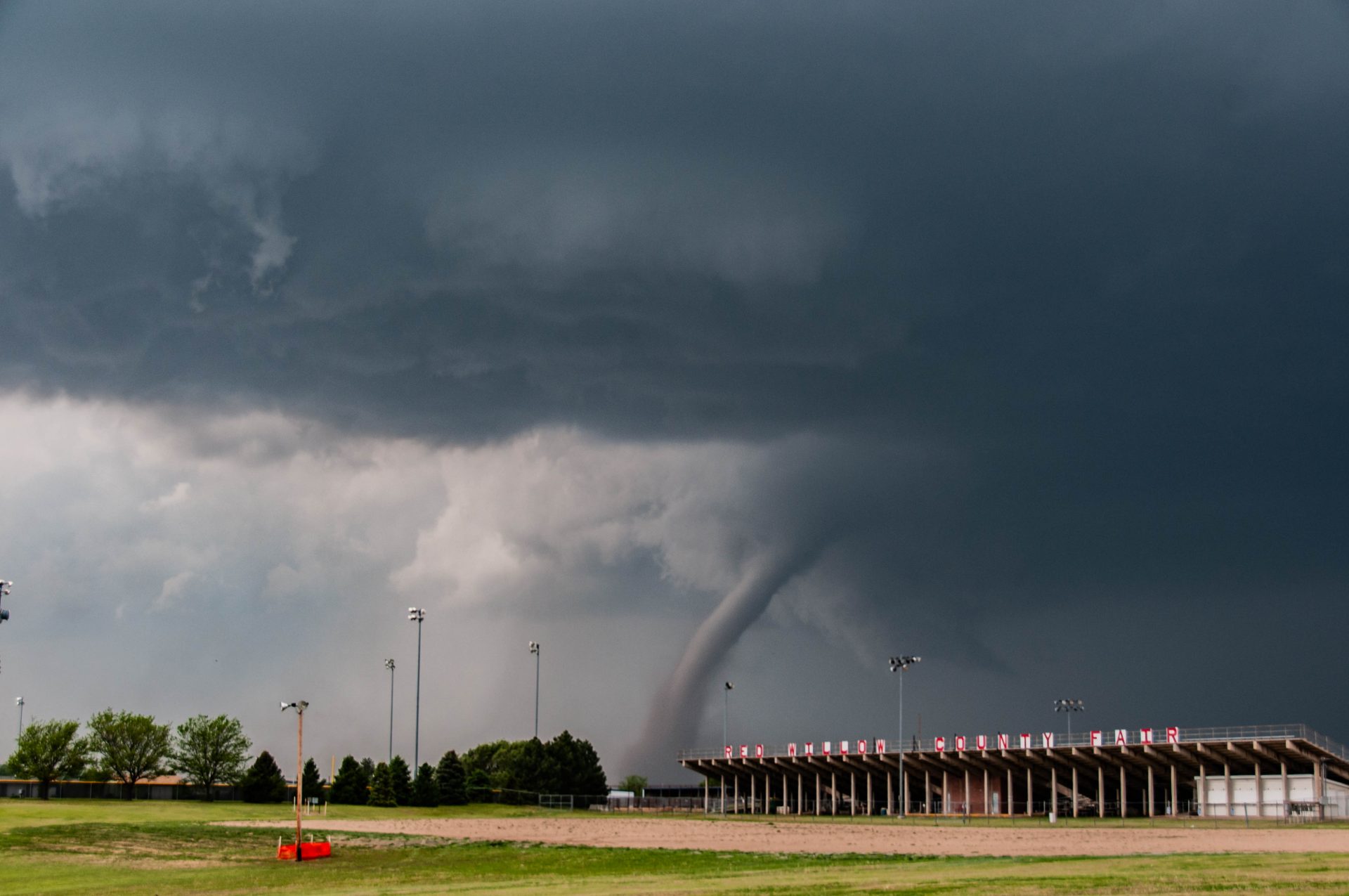
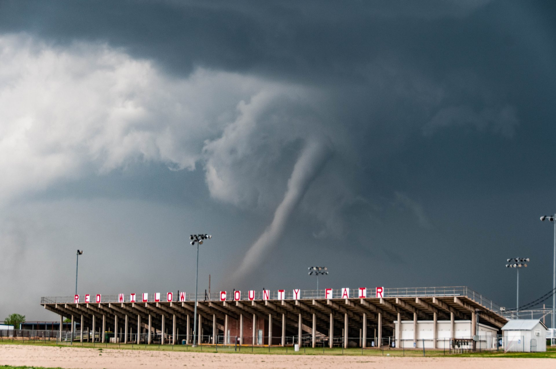
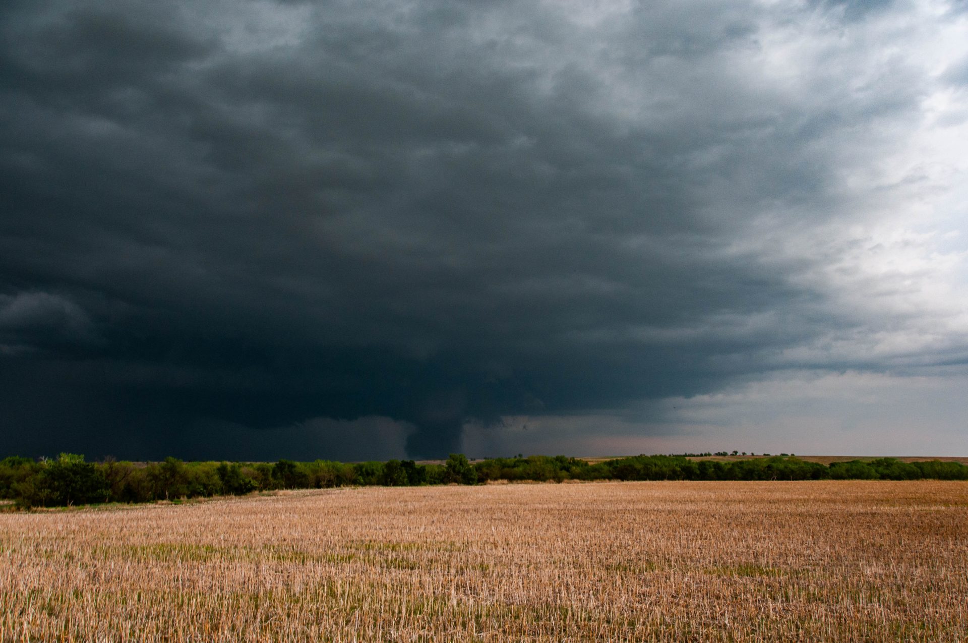
As we began to meander east a couple of miles, a new tornado warning polygon came out through radarscope. Upon clicking the warning, I saw that it was for a confirmed tornado. This was a shock, considering we’d left the storm barely a minute earlier and nothing looked too great. We quickly went three streets to the north and into the parking lot for the Red Willow County Fairgrounds. I noticed a large puff of RFD dust on the ground to the immediate left of the circulation. Then I looked right. Directly in front of us was a large, ghostly gray tornado with a huge brown and gray dust column extending about a third of the way up the tube. We threw the car in park and ran out into the field to witness one of the more beautiful tornadoes I’ve ever seen. The tornado appeared perfectly juxtaposed with the bleachers at the fairground, an ominous sight to anyone who might have been there on another day. Luckily, the fair was closed to the public on May 17th, though this scene was far more enjoyable than trying to win a goldfish by tossing a ring around a milk jug. As the tornado slowly cut across the horizon, the upper portion of the vortex displayed incredible motion as the RFD began to bend the rope in all different directions. After about five minutes, the tornado was gone.
After the tornado lifted, we rushed into position to continue to view the storm. We found a road that took us right under the mesocyclone, and we watched as a new wall cloud developed and twisted a mile or so to our north. As many tornadic thunderstorms do, the storm had slowed down significantly and began to turn to its right (relative to its mean direction of propagation). Wanting to keep up with it but stay out of the tennis ball sized hail mentioned in the warning, we decided to track eastward on a dirt road that our GPS assured us would put us in good position. Big mistake. The GPS was incorrect in its road placement, and we drove seemingly aimlessly for several miles as the storm in front of us slowly drifted further and further away.
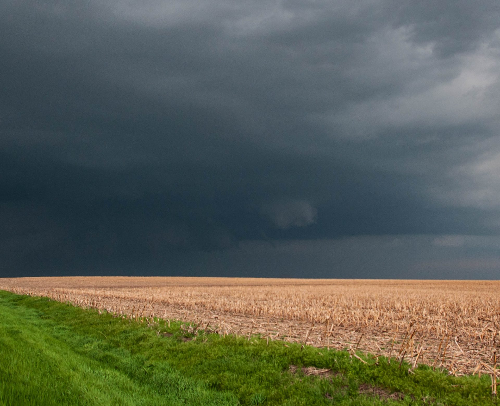
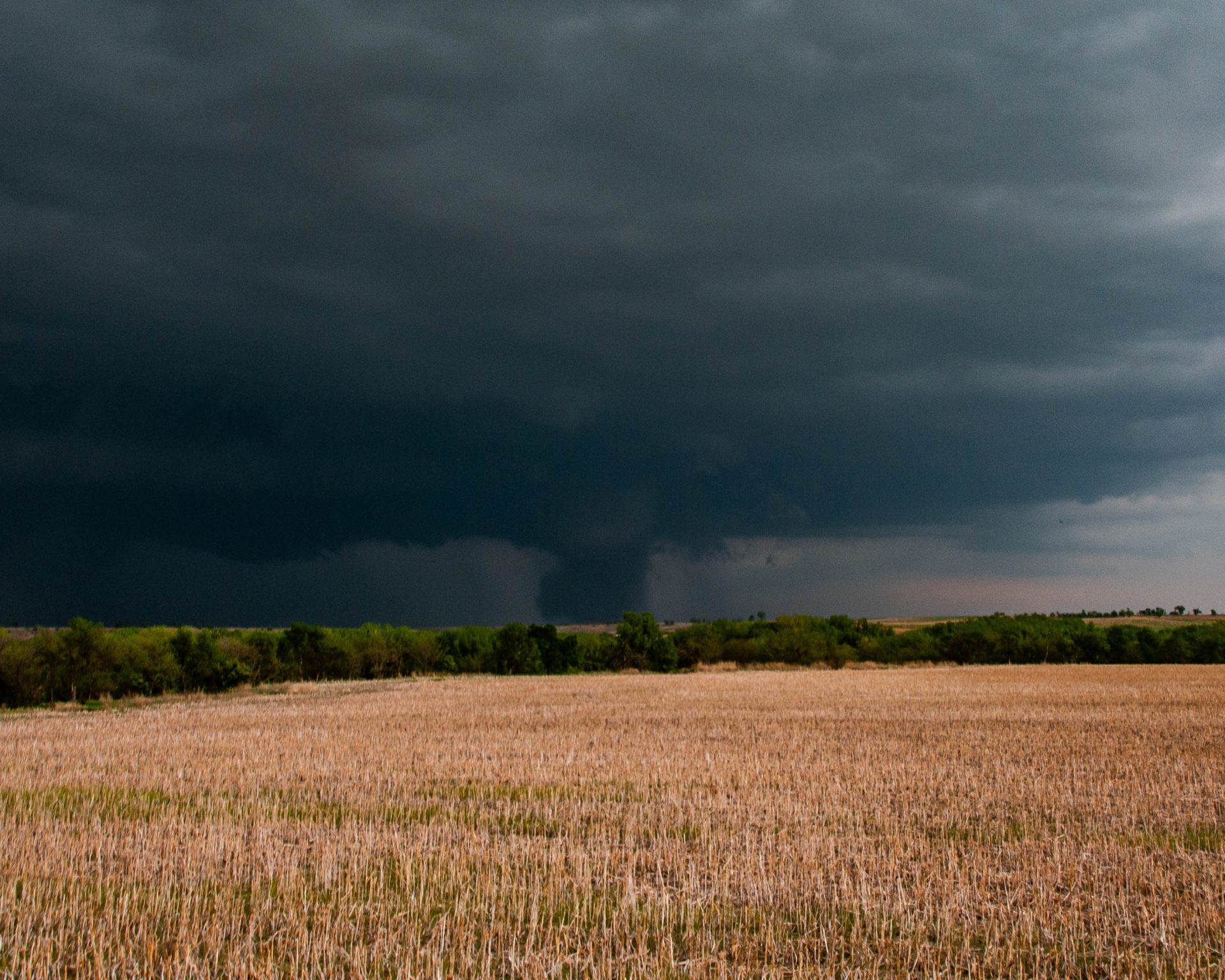
After several excruciating minutes, we regained our bearings and were able to make progress back towards the storm’s main circulation. Just as we began making real headway, a snaky funnel appeared and stabbed toward the ground. Although we struggled in the haze to make out a confirmable touchdown, I discovered that a small dirt swirl was evident underneath the vortex in my photos. Comparisons with pictures from chasers who were closer confirmed the touchdown of tornado number two on the day.
After a couple of minutes, the funnel retreated into the wall cloud to mark the end of the tornado. As we pressed on, I noticed that underneath the same wall cloud a large cylinder of dirt was present. We were several miles away, but I was certain this was a large tornado. We attempted to position a little closer only to discover that just around the bend was a small patch of hills surrounding the road. Over an excruciating 30 seconds, we drove through the hills and finally popped out to discover a large, dusty tornado on the horizon near Stockville, Nebraska. We threw the car into park and jumped out to witness the beast.
After watching for a few minutes, we piled back in the car and pressed on to stay with the storm. We lost visuals for a couple of minutes as we passed through a patch of trees, only to emerge to the tornado now having taken the form of a gorgeous elephant trunk. Unfortunately, the vantage point we had wasn’t particularly favorable for high-contrast photos and mine didn’t come out very good. At this same time, many chasers including John were privy to an absolutely gorgeous view of a high-contrast white tornado. I am immeasurably jealous.
At this point, the chase was largely over as roads became blocked by debris. We continued to try to get into position but had become outflanked by the storm. Facing the realization that we likely weren’t catching back up with the storms, we began to make our way back to the hotel, satisfied with our haul. As it turns out, the first tornado near McCook was rated as EF-2, and the larger tornado near Stockville was rated as a high-end EF-3. All in all, a really fun day in which we made a great forecast and were rewarded, even in the face of a couple of not so great tactical decisions. Not bad for a day at the Red Willow County Fair.
And I no longer despise chasing in Nebraska — for now.
Community Comments
There are no comments on this post
Want to leave a comment? Join our community → OR Login →