
National Centers for Environmental Information reports:
![]()
The tornado began in DeRidder Louisiana just north of 171 on East 1st Street where it created minor roof damage and took out several overhead doors. The winds at this time were estimated at 78 mph. As the tornado moved northeast, it strengthened near Mac Sterling Road crossing into Vernon Parish near the intersection of John Brewer and Borel Roads. Roughly 40 structures were in the path of the tornado with various degrees of damage. Two homes had exterior walls collapse with the interior remaining intact. Numerous trees and power lines were also downed. The max estimated winds while in Beauregard Parish was 152 MPH.
The tornado began in Beauregard Parish and moved into Vernon Parish near the intersection of John Brewer and Borel Roads as an EF3 with winds estimated at 152 MPH. A fatality occurred on Borel Road as the tornado passed around 11:18 am CST. Extensive damage occurred to well built homes as well as mobile homes. This developing long track tornado continued moving northeast crossing Churchman Road where it ripped large open areas off home roofs. Winds were estimated at 135 mph. The tornado moved across forest areas of the southeast part of the Fort Polk Army Base. The tornado crossed into the east central part of Vernon Parish where trees and several homes were damaged around the Sandhill and Coral Roads area with winds estimated at 74 to 107 mph. The tornado moved in Rapides Parish 1 mile south of Highway 121. Roughly 26 structures were damaged along the path.
The tornado moved into Rapides Parish from Vernon Parish crossing Highway 121 as an EF1. Large branches were snapped off. The tornado was about 230 yards wide as it crossed Hwy 1199 and Clint Louis Road. The tornado continued to uproot or snap trees and at this point was about 8 miles southwest of Alexandria.
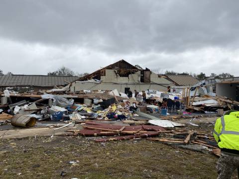
The tornado strengthened again briefly to an EF3 as it began entering the western part of the Alexandria area. Mobile homes, warehouses, and homes on slabs were all heavily damaged or destroyed in the Ross Lane and Hwy 128 locations. A recreational baseball park was destroyed as well as a Chevron Gas station. The tornado then weakened to an EF2 as it moved further east into the Cloverleaf Blvd and Larkspur Drive residential areas. Trees were uprooted onto homes and carports with a few homes with significant roof structure damage noted.
The tornado continued to weaken to an EF1 as it move east tossing or turning over travel trailers at the Cenla RV Center. The tornado then moved across the Red River snapping the tops of trees at Highway 165 and Rainbow Drive. Finally, the tornado moved to Edgewood Drive where trees were snapped and home damage occurred as very tall pine trees were snapped or uprooted and fell onto several homes. The tornado then moved further east where it quickly weakened and dissipated. Max estimated winds in Rapides Parish was 158 MPH. Roughly 575 structures were damaged.