

According to Environment and Climate Change Canada, “fourteen tornadoes struck several Ontario communities, namely Barrie, Grand Valley, Orangeville and Tottenham. The Barrie tornado killed eight people. In all, the family of tornadoes injured hundreds of people, destroyed or damaged over 1,000 buildings and killed 12 people, tying it with the Pine Lake, AB tornado in 2000 as the fourth deadliest tornadic day in Canada. The Grand Valley tornado that began near Arthur and moved east to Campbellford is considered one of the longest tracked tornadoes in Canada, travelling over 115 km” (ECCC, 2017).
At 4:52 on the evening of May 31, the fifth and final tornado produced by the “northern supercell” touched down just six kilometres southwest of downtown Barrie, along Essa-Barrie Townline. The tornado almost instantly attained violent characteristics, cutting a house in half, spraying its debris, and demolishing a nearby barn.
It then cut through a bush lot and nearby tree plantation along Ardagh Road, snapping the uniform pines as little as two metres off the ground. As it progressed to the north side of Ardagh Road moving ENE, the tornado increased in width to 600 metres and surged in strength. Witnesses in the immediate area described seeing whole trees being uprooted and shot through the air like missiles.
Ripping through a bushy area on the edge of town, it took aim directly for the neighborhood surrounding Patterson Road. The vortex engulfed the entire block of small houses running up Crawford Street, Patterson Road, and Moon Drive. Nearly every structure was flattened along its path, leaving behind a sobering scene of cut up and twisted wreckage where two women and three children sadly lost their lives.
Just east of Moon Drive, the tornado next struck the industrial park on Morrow Road. Here it completely destroyed twelve factories and commercial buildings while leaving four others damaged on its periphery. At one of the businesses, a twenty-seven-year-old employee was blown 300m from the collapsing structure to a field near highway 400 where he was found dead, being the tornado’s 6th casualty.
Crossing Highway 400 on the north side of the Essa Road interchange, the tornado tossed vehicles like toys and hurled debris from the now-gutted factories wrapping them around nearby fences, light standards and guard-rails. Miraculously, only minor injuries were reported along the highway.
On the east side of the highway, the tornado passed over the south side of the Barrie Raceway, a local horse racing venue. It completely wiped out several occupied barns, stables, and outbuildings and ripped the roof off the main building and grandstand. On the northeast side of the property, the Barrie Curling Club building also sustained roof damage. In an adjacent parking lot, another twenty-seven-year-old man was blown out of his car and thrown. He was found by rescuers afterward barely clinging to life. Although immediately rushed to Sunnybrook Hospital in North Toronto, he succumbed to his injuries. Fifteen others were injured to varying degrees on the property.
As the tornado blasted across Essa Road it unleashed its fury on the businesses and office buildings lining the route. This included a realtor office, two motels, a car dealership, and a two-story government building. All of these structures sustained severe damage along with 17 cars at the dealership.
Along this same stretch of road, a young man who was driving in his van also encountered the tornado, which was fully rain-wrapped and difficult to recognize at close range. The vortex sucked him out of his seat and flung him across the road, where he came to rest along a chain link fence. Amazingly he survived but not without serious injuries. He was given only a 1% chance of survival, but doctors and medics managed to save his life.
Plowing its way east into the residential community of Allendale Heights, the tornado smashed through a townhouse complex on Adelaide Street, ripping off its roofs and most of the upper floors. Some units had nearly collapsed altogether. As well, immediately south of the townhouses on Debra Crescent, several residences were inundated by tornado’s extreme power, with many reduced to a tattered mess of broken up rafters, drywall, and other building materials. Others appeared to be twisted off their foundations with vehicles overturned in their driveways.
Innisfil Street was next in the tornado’s path. St John Vianney Catholic School located across the street from the now ruined townhouses had its west wing badly damaged. Half of its roof was torn off leaving classrooms exposed. Further east along the street, the majority of houses had their entire upper floors sheared off, broken up and scattered throughout the neighborhood. Their terrified occupants, hearing the intense roar of the storm, scrambled to take shelter.
Crossing Marshall Street, the center of the tornado passed between Murray Street and the west end of Innisfil Street. Here the tornado unleashed its violence again on the bulk of dwellings lining the normally quiet cul-de-sac, with some being completely destroyed.
The tornado then crossed Bayview Drive north near the intersection of Springhome Road. Significant structural damage occurred to a number of homes as it whipped by. Many losing their entire roofs as if chopped off with a giant scythe. Tower Crescent, Glen Court, Woodcrest Road, and Greenfield Avenue all suffered similar damage with neighboring Greenfield Park peppered with building fragments.
Nearing Briar Road, the tornado went through a very brief weakened phase, narrowing to about 80 metres and causing only light damage. This was short-short lived though as it progressed to the new Trillium Crescent subdivision. At this location, recently built homes were wiped off the map as the tornado showed its strength again. Along the brand-new Autumn Lane, houses were swept away, with only a trail of wreckage remaining where they stood only moments earlier.
On the west side of Highway 11, a secondary disaster was narrowly avoided as the tornado took out four warehouses lining the road. One of these properties was home to a propane distributor who had large filled tanks on site. As the tornado struck, it threw a school bus onto the property, where it landed between two of the tanks. After the tornado, local fire officials stated that were the bus to have punctured the tanks, it would have caused a massive explosion, potentially killing hundreds. This miraculously did not occur as the tornado continued east across Highway 11 into a wooded area where a 100m wide swath of trees was flattened.
As the tornado roared over Hurst Drive near the intersection of Tollendal Mill Road it would claim it’s final victim. Trying to seek shelter from the storm, a nine-year-old boy was biking back from the Brentwood Marine dock to his Autumn Lane home when he unknowingly drove into the tornado’s path. Sadly, a sharp piece of debris struck his neck and he died.
The tornado’s fury continued through an area of thick pine forest and upscale subdivision of Tollendal on the shore of Kempenfelt Bay. The heavy trees were flattened but only moderate damage to property took place to residences around Royal Oak Drive as the homes were well-built. At the east end of Royal Oak, the Minet’s Point Marina was the last place the tornado would strike. As many as 35 boats with their concrete anchors were blown away never to be seen again according to police reports. Other boats along with anything left exposed was whipped up into a jumbled mess along the docks. As the tornado continued east-northeast over Kempenfelt Bay, one witness described seeing a black and purple cone-shaped funnel cloud out over the water. It would then dissipate mysteriously somewhere over Lake Simcoe. In the days following, a pilot flying over the Lake would report pieces of debris floating nearly 20 km out in the water.
It was all over in about ten minutes but the infamous “Barrie tornado” as it would now be called, left a long-lasting impression on those who witnessed its incredible destruction. In the days after, scientists and researchers would ultimately give the tornado an F4 rating based on the brutal destruction and violence exhibited upon buildings, vehicles, and infrastructure. A total of 155 people were reported with serious injuries, many needing hospitalizations. With the eight fatalities reported, the tornado would also go into the record books as the third deadliest tornado in Ontario and the seventh deadliest in Canada.
As many as 605 houses were severely damaged, at least 240 deemed uninhabitable. It would list as one of the costliest natural disasters ever in Canada totaling $117 million dollars.
With many businesses destroyed, there were also consequences for the local economy which was already facing a recession.
The Forecast
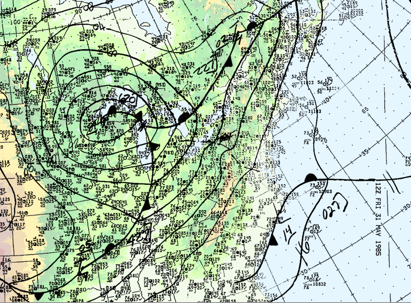
On the morning of May 31, 1985, warm air was advecting northward across Ontario. Figure 1 depicts the surface analysis on the morning of May 31st. In Figure 1, we can see a warm front advecting northward across Ontario and a cold front moving eastward (entering Michigan). The cold front would later provide the trigger for explosive supercell thunderstorm development. According to M. Leduc, O. Jacobsen and B. Greer (1986), “the morning analysis at Environment Canada’s Ontario Weather Centre (OWC) indicated that the thermodynamic and dynamic features necessary for the possible development of severe thunderstorms were present”. As a result, severe weather watches were issued at 2:40 am local time for southern Ontario and extended for all of southern Ontario at 7:00 am, 9:20 am and 1:50 pm, advising the population of potential severe thunderstorm development later in the day (Leduc et al., 1986).
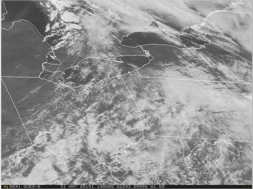
At 18Z (2:00 pm EDT), the cold front was entering Ontario (Figure 2). According to Leduc, et al. (1986), an unseasonably strong low pressure centre tracked across upper Michigan during the morning hours to just north of Sudbury by evening. The visible satellite loop below shows the development and explosive growth of thunderstorms across southern Ontario, Ohio, western Pennsylvania and western New York on the afternoon of May 31st.
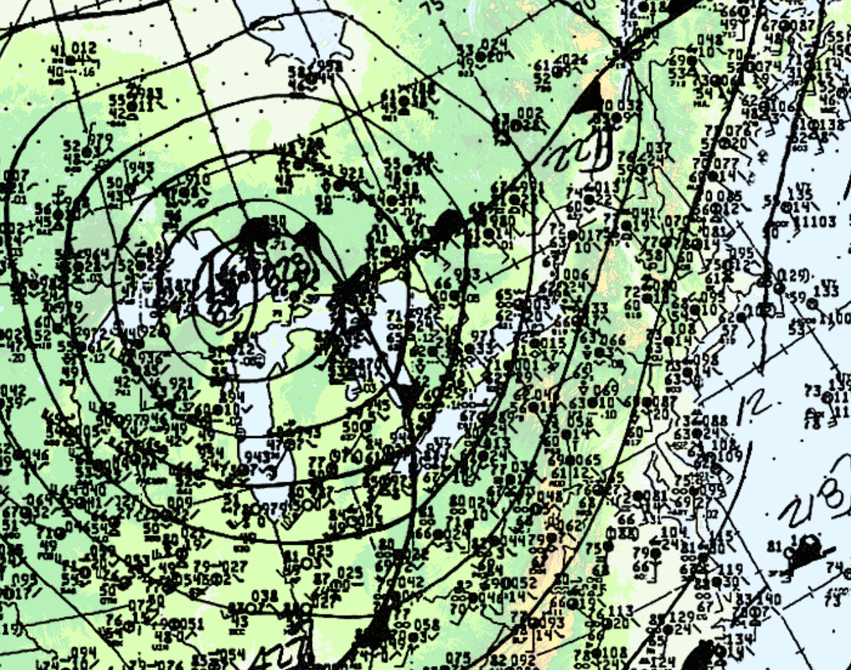
At 21Z (5:00 pm EDT), the time of the Barrie F4 tornado, the cold front was in western Ontario (Figure 4).
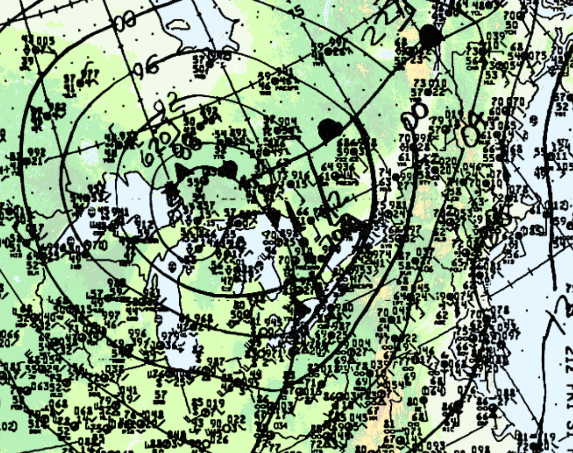
Leduc et al. (1986) notes that the dynamics in place were strong since a sharp cold front (Figure 1, 2 and 4) and an upper trough was crossing Michigan, bringing with it strong westerlies in the upper-levels of the atmosphere.
The tornado
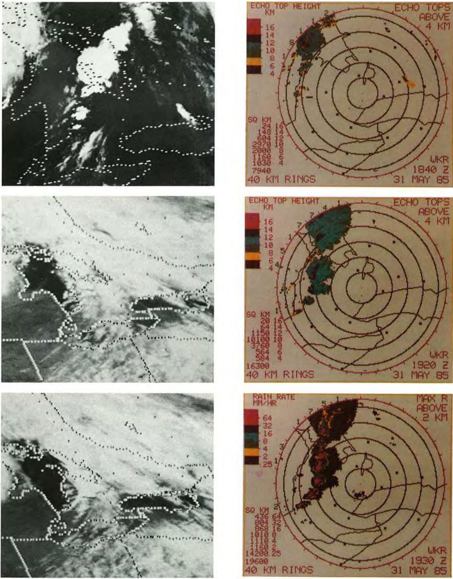
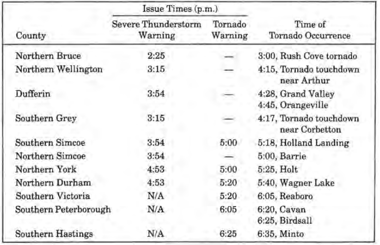
Figure 5 and 6 depict the radar imagery from the King City radar (north of Toronto). At 1:40 pm (local time), radar showed the first thunderstorms developing west and north of the Bruce Peninsula. By 2:20 pm, a line of severe storms was indicated by radar (Figure 5). The first severe thunderstorm warning was issued at 2:25 pm for the Bruce County and Parry Sound District. At 3:15 pm, severe thunderstorm warnings were issued for Huron, Perth, Grey, northern Wellington and northern Waterloo Counties, with the most intense storms being seen from Meaford to Perth County (Leduc et al., 1986). At 4:00 pm, reports of 2-cm hail and very high winds were received at the OWC for the Meaford and Dundalk area. Around 4:00 pm, radar showed a line of severe storms extending from Collingwood to eastern Perth County moving east at 60-70 km/h (Figure 6).
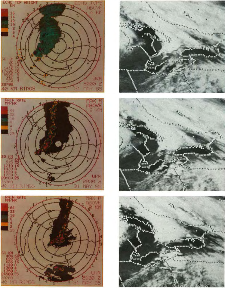
Between 4:20 pm and 4:40 pm, radar showed signs that the southern storms off the squall line were intensifying and therefore warnings were issued at 4:53 pm from Hamilton-Wentworth to Durham and Victoria counties. A tornado warning was issued at 5:00 pm for southern Simcoe, northern Peel and York counties after OWC received reports of a tornado at 5:00 pm and 5:20 pm. At 5:50 pm severe thunderstorm warnings were issued for the Niagara Peninsula. Tornado warnings were extended for southern Durham and Peterborough counties at 6:05 pm and Haliburton, Northumberland, Prince Edward and Hastings counties at 6:25 pm. At 7:00 pm, warnings/watches were cancelled for all regions, except for Haliburton County and east of Oshawa where tornado reports southwest of Peterborough and Rawden Township were received between 6:40 pm and 7:20 pm. A timeline of tornado occurrence, severe thunderstorm warnings and tornado warnings are presented in Table 1 below.
Aftermath of tornado
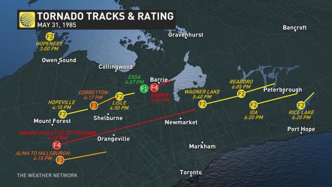
According to Etkin (2002), an F4 tornado touched down near the town of Hopeville. Before it struck Barrie, the funnel moved along the countryside lifting twice and coming back down before striking southwest of Barrie between 4:15 pm and 5:00 pm local time. Moving in a northeastern direction, the tornado hit a pine forest plantation, where 10-metre high trees were broken off. The tornado moved east, where it completely destroyed a square block of older farms and killed 3 people. Cars were thrown hundreds of metres into fields. The tornado proceeded towards an industrial park, where at least 16 factories were heavily damaged or destroyed. One fatality was observed within the industrial complex. In the walls still standing, small wooden splinters were found driven into brick mortar and steel beams were severely twisted. As the tornado crossed Highway 400, damaging several barns near the Barrie racetrack, witnesses reported seeing horses lifted off the ground and “gently replaced some distance away” (Etkin, 2002). Dents and small bullet-like holes caused by flying debris were found in most cars near the 400. Highway guard-rails were found several metres away wrapped around trees and buildings. The sleeping compartment of a semi-truck, which may have originated near the 400, was found on the rooftop of a nearby house. The tornado moved through the Hillsdale area, where four fatalities occurred. At the Barrie marina, 35 boats, including their concrete mooring anchors, were reported to have disappeared and debris from town was discovered five kilometres into Lake Simcoe.
Recap
According to ECCC (2018), the Barrie F4 tornado touched down at 5:00 pm local time and tracked for 15 km through the south side of town, moving in a northeastern direction and ending over Lake Simcoe. The maximum width of the tornado was 600 metres. The F4 tornado killed eight and injured 155. The total damage by this tornado was $150 million dollars.
Sources
Environment and Climate Change Canada (2017). Top Weather Events of the 20th Century. Retrieved from: https://ec.gc.ca/meteo-weather/default.asp?lang=En&n=6A4A3AC5-1#tab5
NWS Weather Prediction Center (2017). North American Surface Analysis: Surface Analysis 12Z Friday May 31, 1985. Retrieved from: https://www.wpc.ncep.noaa.gov/html/sfc2.shtml
National Weather Service (2019). May 31, 1985 Tornado Outbreak: 34th Anniversary. Retrieved from: https://www.weather.gov/ctp/TornadoOutbreak_May311985#Meteorology
M. Leduc, O. Jacobsen and B. Greer (Winter 1986). The “Black Friday” Tornado Outbreak in Ontario. Chinook, 8, 13-18. Retrieved from: cmosarchives.ca/Chinook/ch0801.pdf
The Weather Network (2019). Massive Ontario tornado outbreak marks anniversary. Retrieved from: https://www.theweathernetwork.com/ca/news/article/anniversary-of-the-barrie-tornado-grand-valley-tottenham-may-31-1985-tornado-outbreak
D. A. Etkin (2002). A Tornado Scenario for Barrie, Ontario.
Environment and Climate Change Canada (2018). Canadian National Tornado Database: Verified Events (1980-2009) – Public. Retrieved from: http://donnees.ec.gc.ca/data/weather/products/canadian-national-tornado-database-verified-events-1980-2009-public/?lang=en