

Eight tornadoes occurred on this day, the other tornadoes were:
- Beaumont, AB F2 Tornado
- Leduc, AB F0 Tornado
- Edmonton, AB F1 Tornado
- Iddesleigh, AB F0 Tornado
- Blue Ridge, AB F0 Tornado
- Island Lake, AB F0 Tornado
- Millet, AB F2 Tornado
History of tornadoes in Alberta
Tornadoes are not uncommon in Alberta. According to Dr. Keith D. Hage (1988), our atmosphere is in constant motion and responding to local imbalances caused by differential heating. Sometimes, cumulus clouds and thunderstorms aren’t enough to correct these imbalances and tornadoes are “needed”. Figure 1 depicts the variations in tornado frequency between the years of 1890 to 1910. According to Hage (1988), 90% of the strongest tornadoes occur between June 1 and August 15.
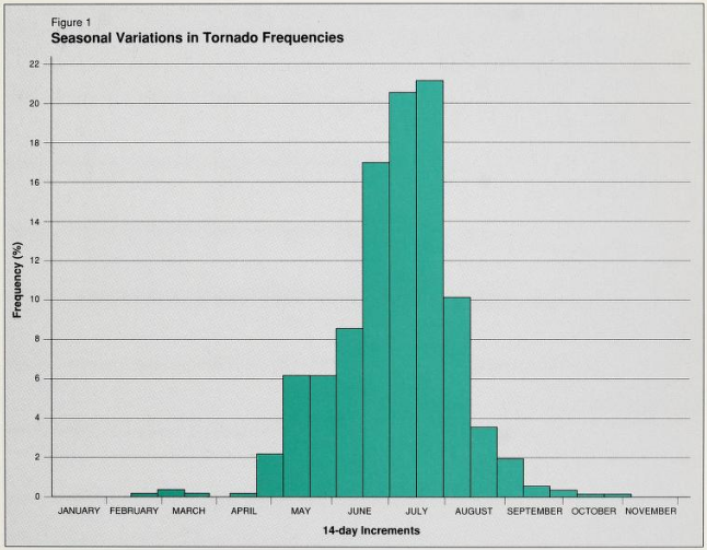
Reports of tornadoes, especially in the early 1900’s were uncommon due to sparse population. Tornado research continues to be an active area of study due to a thin data-set. Please note that these figures are outdated, however we present them due to their relevance with the July 31, 1987 tornado that hit Edmonton in Alberta, Canada. From these figures, taken from the Alberta Public Safety Services (APSS) report of 1988, we can see that the Edmonton tornado wasn’t that “abnormal” in occurrence. Figure 2 depicts the spatial variations in tornado frequency across Alberta and Saskatchewan between 1910 and 1960.
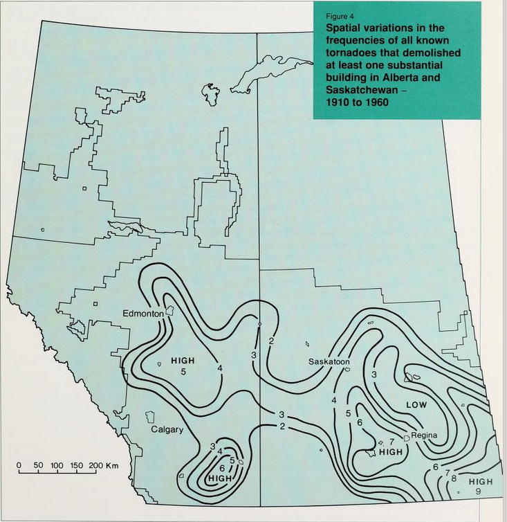
While Figure 2 is based on “frequencies of all known tornadoes that demolished at least one substantial building in Alberta/Saskatchewan” (Hage, 1988), it depicts three regions of high frequency: southern/central Alberta, south-central Saskatchewan and southeastern Saskatchewan/southwestern Manitoba. Hage (1988) specially noted that numbers outside of depicted circles are likely underestimated due to poor observational records, where records are bound closely to population centres.
The Edmonton F4 tornado
According to Hage (1987), “the last week of July 1987 was hot and humid with frequent thunderstorms over much of Alberta. Weather maps were characterized by a weak low-pressure trough over central Alberta at the earth’s surface, and a strong flow of air from the southwest at high levels”.
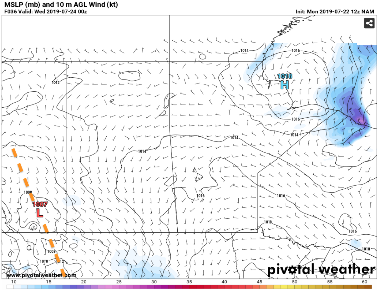
Figure 3 depicts a NAM 12km resolution model depiction of a similar trough and weak low pressure system that could have been seen on the last week of July 1987 for Alberta. This type of pattern is quite common in Alberta and usually spawns multi-day severe weather events as southerly flow pools warm/moist air against the Rocky Mountains. The low pressure provides the lift needed for thunderstorm development along the foothills. This is exactly what happened in the last week of July 1987.
Surface dew points were observed at 20C throughout the week. According to NOAA (2009), dew points are a measure of atmospheric moisture. It is the temperature at which air must be cooled to reach saturation (i.e. condense and make clouds). Higher dew points indicate more moisture is present in the air. Figure 4 depicts an example of moisture content in the atmosphere. Figure 4 depicts dew point temperatures in the low 20’s for Tuesday July 23, 2019 near Edmonton, AB. This map could have resembled the last week of July in 1987.
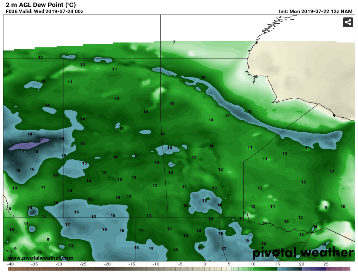
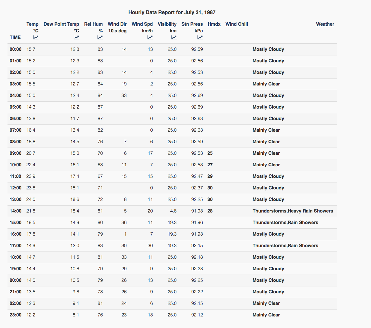
Table 1 depicts actual observations at the Edmonton International Airport on July 31, 1987. It shows a temperature maximum at 1:00 pm of 24C with a dew point temperature of 18.6C.
Before the July 31st F4 Edmonton tornado, 14 tornadoes ranging from F0 to F2 intensity were reported between July 25th and July 30th from southern Alberta to northern Alberta. According to Hage (1988), most of these tornadoes were not known to the Alberta Weather Centre until days or even weeks after they occurred.
On Friday July 31st, the atmosphere was far from done dropping tornadoes in Alberta. A line of thunderstorms formed (presumably along the surface trough) in the early morning hours on Friday along the foothills southwest of Calgary. This line of storms intensified as they moved northeast to reach a line from Ponoka to Sangudo by 2:30 pm local time. By 2:45 pm, explosive storm development occurred ahead of this line near Leduc and dropped a brief tornado. This isolated storm then headed towards Beaumont, where it dropped what is now known as the “Edmonton tornado” at 2:55 pm, which remained on the ground for an hour and over a 40 km path (Hage, 1988).
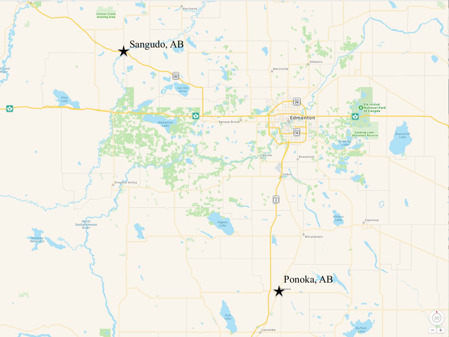
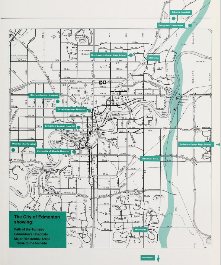
Figure 5 depicts the line of storms from Sangudo to Ponoka and Edmonton for reference. The Edmonton tornado formed ahead of the Sangudo-Ponoka line. The damage path (Figure 6) is highly variable with damage extending from tens of metres up to more than one kilometre (Hage, 1988). The tornado went from south to north ripping through the east side of Edmonton and parts of Stathcona County. According to APSS (1988), the tornado:
- remained on the ground for an hour, leaving a path of destruction 40 km long and up to 1 km wide in some areas;
- killed 27 people and injured hundreds;
- estimated wind speeds reached up to 420 km/h (shy of an F5 status);
- destroyed more than 300 homes;
- caused more than $330 million dollars in property damage (without inflation).
At the time, the 1987 Edmonton F4 tornado was declared the worst natural disaster in recent history for the province of Alberta (APSS, 1988). The path of the tornado is shown in Figure 6 below.
City of Edmonton Fire Department report
Here are some observations taken from the APSS (1988) report of the Edmonton tornado. These observations were catalogued by the City of Edmonton Fire Department:
- in the Millwoods/southeast industrial area, 12-15 people were treated with serious injuries;
- the Evergreen Mobile Home Park sustained a two-block-wide path of destruction that destroyed 170 mobile homes, killed 15 people and injured many. During the following day, the Fire Department conducted search and rescue operations and assisted in the recovery/removal of bodies.
Fire Department critiques after the event:
- radio traffic was a major issue;
- need better system of registering injured/missing;
- every man should have emergency flashlight (possibly helmet-mounted);
- some search and rescue crews should carry tape to avoid searching areas already searched;
- etc.
Edmonton RCMP report
According to APSS (1988), the Edmonton RCMP was advised at 3:28 pm local time that a tornado was heading towards Sherwood Park. At 3:36 pm, the Starthcona County Fire Department advised that the tornado had touched down on the Sherwood Park Freeway at 17th Street. Here is a timeline of RCMP communications:
3:47 pm: Strathcona Refinery security advises tornado hit area
3:51 pm: propane truck with split tank at 17th Street and 84th Avenue
3:52 pm: 20 000-volt power line down at 17th Street and Baseline Road
3:53 pm: injured people reported at Mountain Pipeline
4:03 pm: ambulance requested at Everall Construction for critical injury of man with pole through his body
Initial RCMP observations:
- total devastation of buildings;
- vehicles totaled and dysfunctional on highways;
- multiple injuries requiring medical treatment and transportation to hospitals;
- gas line leaks;
- etc.
Lessons Learned
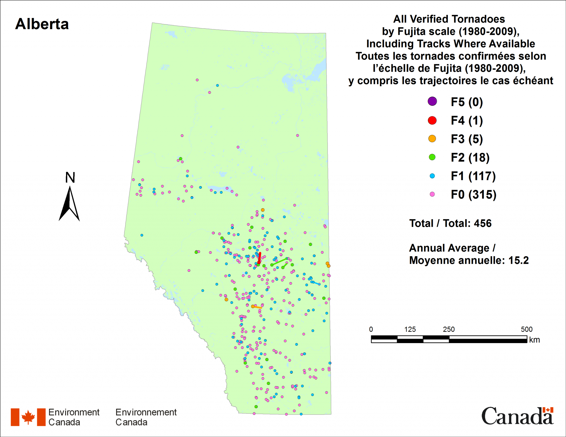
Many lessons were learned from this historic event of July 31, 1987. Tornadoes will continue to happen for the the province of Alberta in the future. The only thing that we can do is learn from previous events and be better prepared for the “next one”. Figure 7 depicts confirmed Alberta tornadoes between 1980 to 2009 by Environment and Climate Change Canada, depicting an annual average of 15.2 and a total of 456 (up to 2009). Reports of tornadoes will continue to increase with population growth in the future. This does not mean that tornadoes are “more frequent”, it just means that more people are there to witness them and possibly live in their paths. Damaging tornadoes may increase in frequency in the future simply because geographical sparsity decreases and infrastructure is increasing.
Recap
According to ECCC (2018), on July 31, 1987, a tornado touched down at 3:03 pm local time near Edmonton, AB (Figure 6). The tornado was 1.3 km wide, stayed on the ground for about one hour and tracked about 30.8 km. Top wind speeds were up to 420 km/h. 27 fatalities and 300 injuries were observed from this tornado. The damage done by the Edmonton tornado was $260 000 000 (without inflation).
Sources
Hage, K. D. (1988). A History of Tornadoes In Alberta. Tornado, a report : Edmonton and Strathcona County, July 31st, 1987. Retrieved from: https://archive.org/details/tornadoreportedm00albe_0/page/6
NOAA’s National Weather Service (2009). Glossary: Dew Point. Retrieved from: https://w1.weather.gov/glossary/index.php?word=dew+point
Alberta Public Safety Services (1988). Tornado, a report: Edmonton and Stathcona County, July 31st, 1987. Retrieved from: https://archive.org/details/tornadoreportedm00albe_0
Environment and Climate Change Canada (2018). Canadian National Tornado Database: Verified Events (1980-2009) – Public. Retrieved from: http://donnees.ec.gc.ca/data/weather/products/canadian-national-tornado-database-verified-events-1980-2009-public/