Conway, MA EF1 Tornado of February 25, 2017


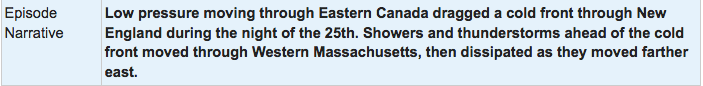
Figure 1 depicts the surface observations at 8:00 pm EDT, which shows a cold front moving across the northeastern United States. Warm air advection, aided by low pressure in western Massachusetts, triggered thunderstorms in the evening hours of February 25th, which ultimately led to two EF1 tornadoes across the state.

Figure 1. Surface analysis at 00Z on February 26, 2017 showing mean sea-level pressure (MSLP) contours, surface observations, fronts and pressure centers (WPC, 2017)

The Conway, MA EF1 tornado of February 25, 2017 impacted Franklin County in Massachusetts. According to NOAA (2020), the EF1 tornado caused no fatalities, but caused 1 injury and caused $400 thousand dollars in property damage. The tornado touched down near Main Poland Road at 8:23 pm EDT. The tornado travelled for 4.64 miles and had a maximum width of 200 yards.

Figure 2. Episode narrative for February 25, 2017 (NOAA NCEI, 2020).

Sources

NWS Weather Prediction Center Surface Analysis Archive. (2017). Surface analysis 00Z Sun Feb 26 2017. Retrieved from: https://www.wpc.ncep.noaa.gov/archives/web_pages/sfc/sfc_archive.php

NOAA National Centers for Environmental Information (2020). Storm Events Database. Retrieved from: https://www.ncdc.noaa.gov/stormevents/

National Centers for Environmental Information reports:

The second phase of this tornado touched down at 723 pm EST on Main Poland Road in western Conway Massachusetts. The path width started at 50 yards, with a sharp gradient evident of damage versus no damage. Large sections of forest had thick pine trees snapped at mid-tree. Numerous power lines were downed along the path into downtown Conway. The path width grew, reaching a maximum width of 200 yards near the town hall. Several houses were severely damaged on Whately Road, southeast of the town hall. Roofs were blown off, and in one case the side walls of a house were missing with the interior of the house exposed. On Hill View Road a large barn collapsed. One injury occurred when a tree landed on a house on South Deerfield Road east of town. That was where the visible damage path ended.