

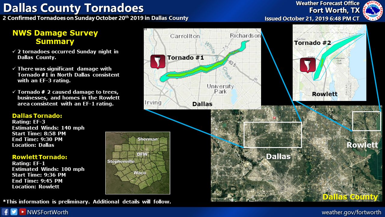
A strong EF-3 (preliminary) tornado struck the northern part of Dallas, TX after dark (8:58 pm CDT) on October 20th. This tornado caused extensive damage and injuries across Dallas County. This tornado was one of three tornadoes that struck Texas that night.
According to the NWS Forth Worth/Dallas (2019), “a survey team has determined that the estimated maximum winds for the tornado in North Dallas is 140 mph, consistent with an EF-3 rating”. While this rating may fluctuate in the next few months, until the official rating is released, we have enough information to talk about this significant tornado.
What made this tornado even worst was the fact that it struck after dark. This meant that the tornado was obstructed by rain as well as the cover of darkness. This caught a lot of drivers off guard, some of which drove right into the tornado’s path as it crossed major roads.
Forecast Analysis
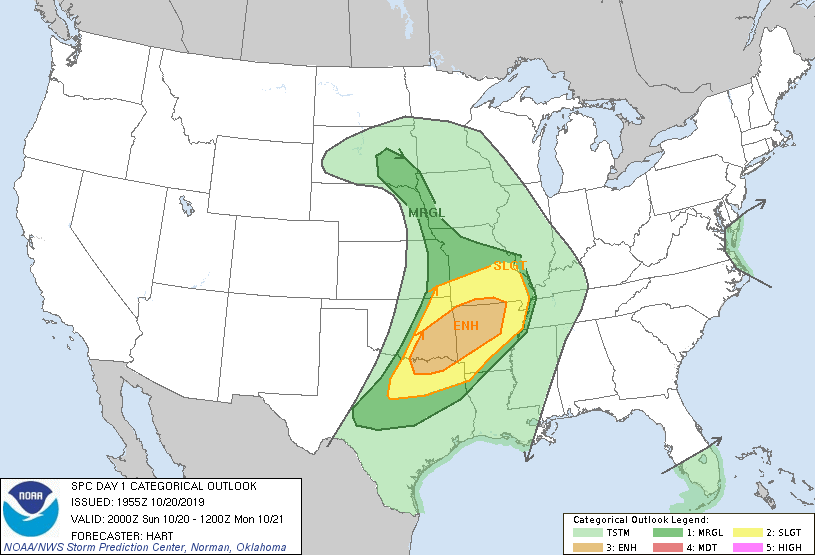
SPC Day 1 Categorical Outlook 20z 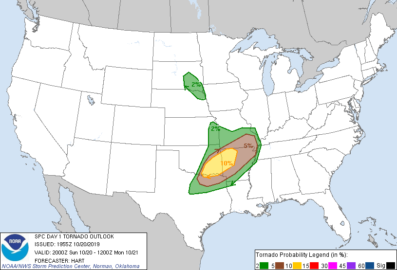
SPC Day 1 Tornado Outlook 20z
The above figures were taken from the Storm Prediction Center’s archive for 3:00 pm CDT. The SPC had issued an ENHANCED risk of severe thunderstorms with a 10% probability of tornadoes within the yellow circled area (right image). It is interesting to notice that Dallas/Forth Worth (DFW) is not included in the 10% tornado probability at this time.
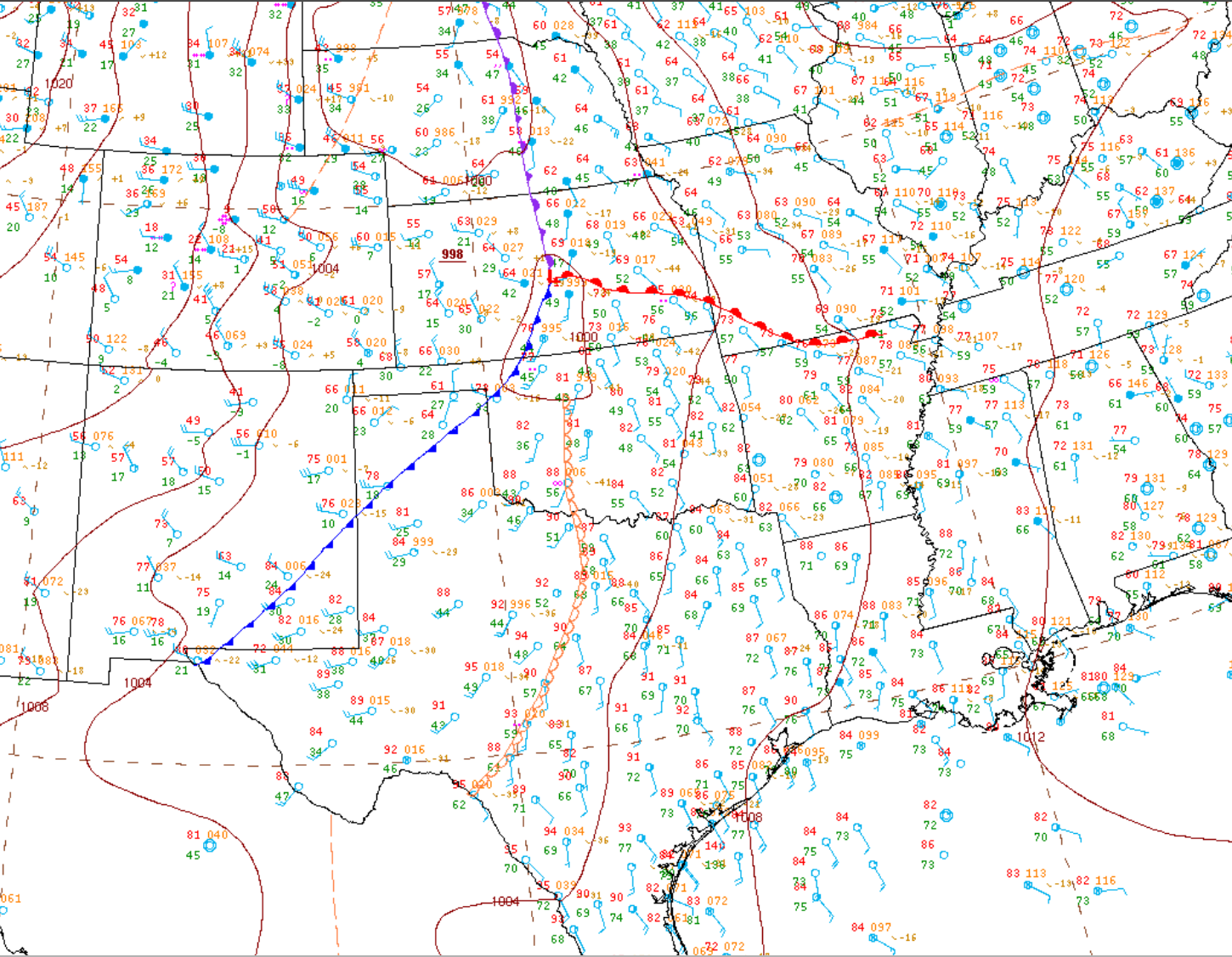
Figure 1 depicts a strong cold front extending from a low pressure in Kansas. A warm front is seen lifting north, extending from said low pressure, creating a large warm sector into Oklahoma and Texas. At 4:00 pm CDT, a dryline was observed (Figure 1) advancing east towards the Dallas.
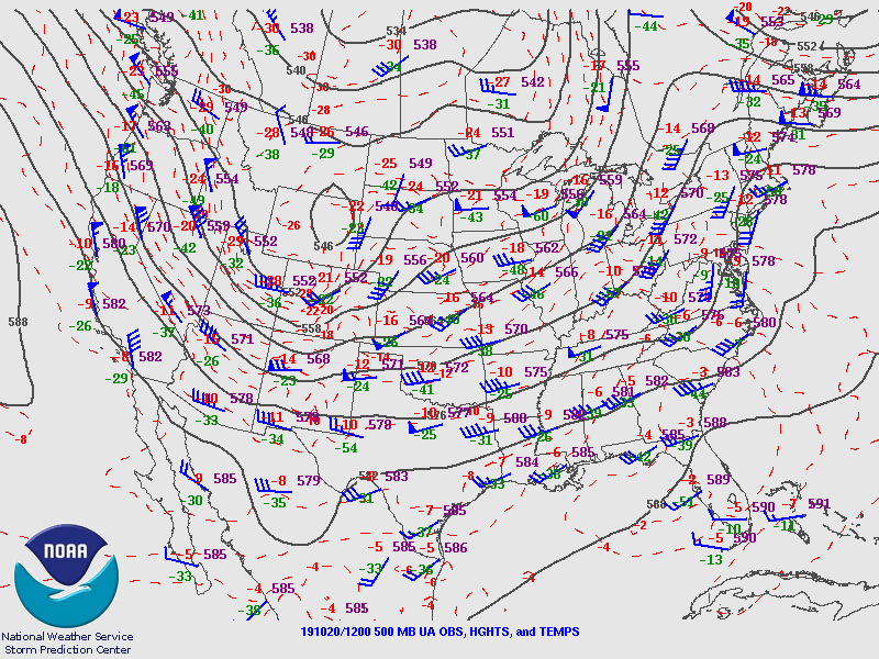
Figure 2 depicts the situation at 500mb up in the atmosphere, which depicts an upper-level trough and its associated upper-level low seen over Wyoming. This trough would become negatively-tilted at 00z, which brought significant forcing across western/central Oklahoma and central Texas.
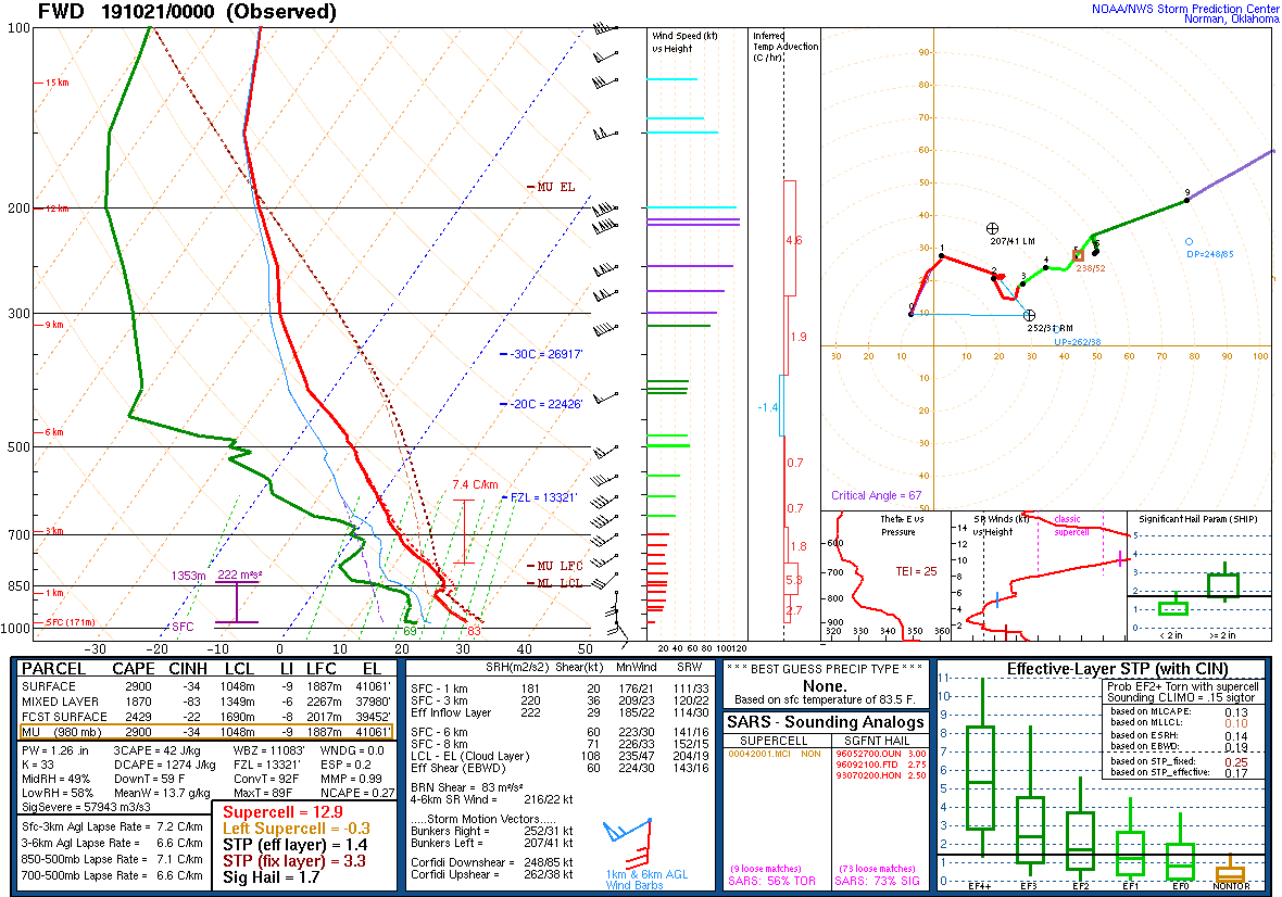
Figure 3 depicts the condition of the atmosphere around Dallas at 7:00 pm CDT, which was about one hour before storms developed. A small cap is observed at 850mb, with large instability and a veering profile. The elongated hodograph suggest tornadoes (some strong) are possible and classic supercells are expected.
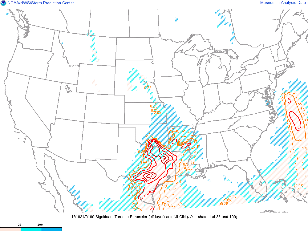
Around 8:00 pm CDT, storms exploded ahead of the dryline, just west-southwest of Forth Worth. Figure 4 depicts a significant tornado parameter (STP) value of 5 east of Dallas with a large area valued at 4, including DFW.
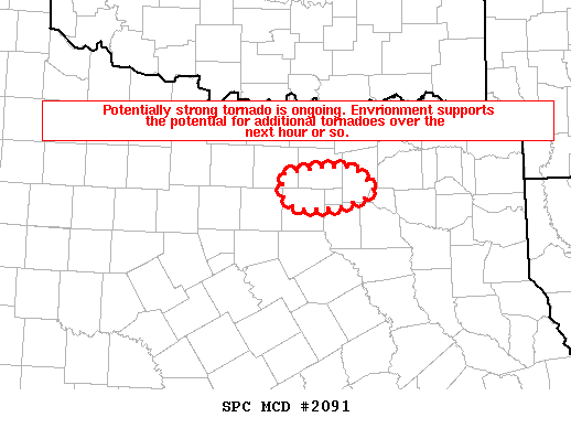
At 8:58 pm, a tornado was reported across social media. At 9:08 pm, the Storm Prediction Center issued mesoscale discussion 2091 (Figure 5), which wrote out:
Mesoscale Discussion 2091
NWS Storm Prediction Center Norman OK
0908 PM CDT Sun Oct 20 2019
Areas affected…North Dallas Metropolitan Area
Concerning…Tornado Watch 676…
Valid 210208Z – 210245Z
The severe weather threat for Tornado Watch 676 continues.
SUMMARY…Tornado is currently ongoing across northern Dallas County. The environment is supportive of a strong tornado, with additional tornadoes possible downstream in the next hour or so.
DISCUSSION…Recent radar signatures from KFWS reveal an intense supercell characterized by a 0.5 degree rotational velocity between 60 and 65 kt. A tornadic debris signature has also been noted on recent radar scans. This signature is occurring in an environment characterized by STP between 3 and 4. Previous signatures within similar environments produced damage-estimated wind speeds from 120 to 160 mph and a confidence is high for an intense tornado.
Preliminary Information Summary
According to the NWS Amarillo, TX (2019), the tornado’s length was 15.75 miles and the width was 1300 yards (~0.7 miles) at its widest. The tornado struck at 8:58 pm CDT and lifted at 9:30 pm CDT. Multiple injuries were reported on social media, but no fatalities have been reported thus far. The preliminary rating for the tornado that struck Dallas County is EF-3, with 140 mph winds (NWS Forth Worth/Dallas, 2019).
Sources
National Weather Service Forth Worth/Dallas. (2019). Dallas County Tornadoes. Retrieved from: https://www.weather.gov/fwd/
NWS Weather Prediction Center Surface Analysis Archive. (2017). Surface analysis 21Z Sun Oct 20 2019. Retrieved from: https://www.wpc.ncep.noaa.gov/archives/web_pages/sfc/sfc_archive.php
Storm Prediction Center. (2019). SPC Event Review for Sunday October 20, 2019. Retrieved from: https://www.spc.noaa.gov/exper/archive/event.php?date=20191020
National Weather Service Amarillo, TX. (2019). Dallas’ Tornado in Perspective. Retrieved from: https://twitter.com/NWSAmarillo/status/1186427514308063232