

A significant supercell exploded southwest of De Ridder, LA in the late-morning hours of December 16th. This supercell produced a long-track tornado near De Ridder, which moved northeast. It is likely that this tornado lifted and a new one formed near highway 121, before making a straight line toward Alexandria, but not enough information is currently available.
The path of this tornado was drawn live as it was occurring based on Doppler radar velocity and correlation coefficient, which showed a fairly consistent path from De Ridder to hwy 121 AND a significant debris ball before crossing Coliseum Boulevard just south of Alexandria’s International Airport, where a tornado emergency was issued. The morning forecast prior to this event has been provided below are well as the radar screenshots.
The Forecast
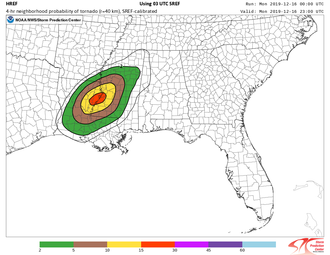
An ENHANCED risk of severe weather has been issued by the Storm Prediction Center, with a 10% tornado risk in parts of Louisiana and Mississippi later today. Above is the calibrated 4-hr probability of a tornado for 6:00 pm CST, which shows between 15-30% chance of seeing a tornado in that red circle.
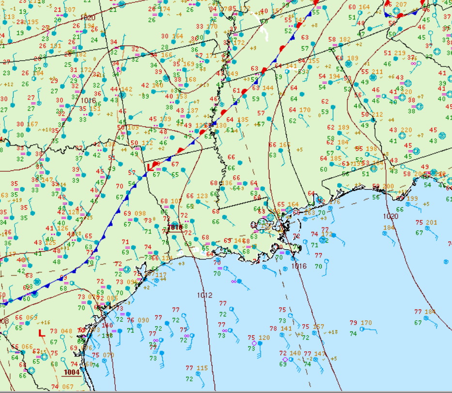
This morning’s surface analysis depicts a stationary front across Arkansas and northern Mississippi and a cold front in eastern Texas. This cold front will move east throughout the day and trigger semi-discrete supercells throughout the afternoon/evening hours.
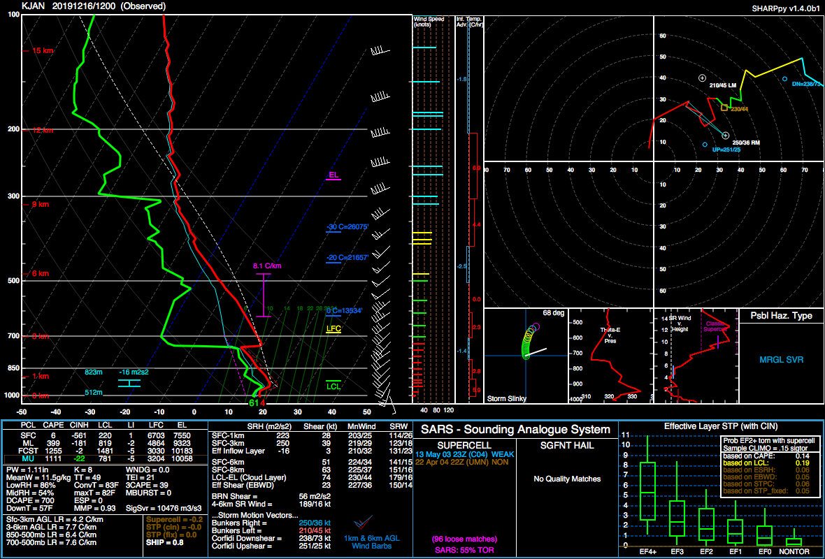
Above is the morning sounding for Jackson, which shows a pretty substantial inversion from 3km to the surface. This makes sense when looking back at our surface analysis, we can see fog codes (“=”) near Jackson. We can therefore assume this sounding is pretty accurate. When we look at the mid-levels, we already have some instability here with 1111 MUCAPE. The mid-level lapse rates are already steep at 7.6 C/km, but the 0-3km lapse rates are absolutely stable at 4.2 C/km.
Therefore, if we want supercells later today, the inversion needs to be overcome and temperature increased to increase the surface lapse rates. In other words, we need surface heating to mix the 0-3km profile.
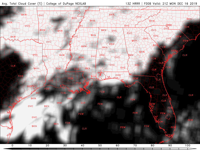
From ensembles and CAM’s, it looks like it will remain pretty cloudy, but with some breaks in the cloud to permit some surface heating. This will be a critical piece of whether a tornado outbreak occurs or we get several non-tornadic supercells.
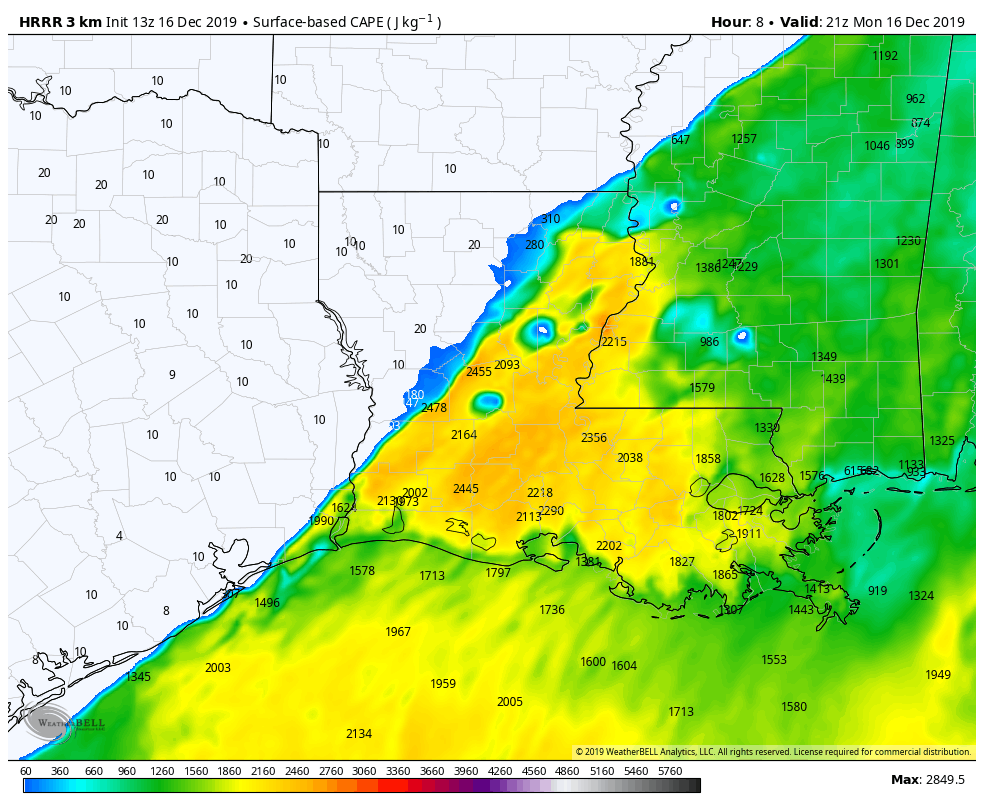
Most CAM’s are currently offering substantial amount of instability near the surface, which would indicate that surface heating/mixing will occur in the afternoon for parts of LA/MS.
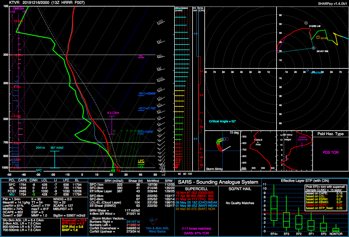
NAM NEST and HRRR are in agreement with the above forecasted sounding for Vicksburg, which is on the LA/MS line. In this sounding, we have a mixed profile with a well-defined inverted V at the surface. This is a tornadic profile. Lapse rates 0-3km have increased to 6.4 C/km and temperatures at the surface are 74F.
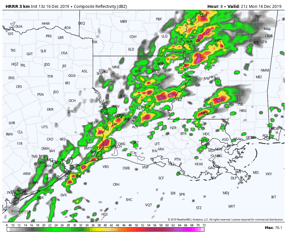
If we look at the simulated reflectivity for roughly the same time, we see some massive semi-discrete supercells in the vicinity of those soundings. This would indicate that the environment around the LA/MS line will be favorable for some nasty supercells that will likely produce several tornadoes later this afternoon into the evening hours.
The Outcome
Below is a rough timeline of the long-track tornado as observed in real time.
National Weather Service Lake Charles LA
1226 PM CST Mon Dec 16 2019
Tornado Warning for…
Northern Rapides Parish in central Louisiana…
At 1225 PM CST, a large and extremely dangerous tornado was located near Otis, or 7 miles northeast of Hineston, moving northeast at 45 mph. This is a PARTICULARLY DANGEROUS SITUATION. TAKE COVER NOW! HAZARD…Damaging tornado. SOURCE…Radar indicated rotation.
BELOW: correlation coefficient shows a significant and well defined debris ball seen in grey, just south-southeast of the radar dish. A new, well-defined debris ball appears just east of highway 121 and remains until reaching US-LA 49 northbound.
...TORNADO EMERGENCY FOR ALEXANDRIA...

The National Weather Service in Lake Charles has issued a

* Tornado Warning for...
  Northeastern Rapides Parish in central Louisiana...

* Until 115 PM CST.

* At 1239 PM CST, a confirmed large and destructive tornado was
  observed near Alexandria International Airport, moving northeast at 25 mph.

  TORNADO EMERGENCY for ALEXANDRIA. This is a DANGEROUS SITUATION.
  TAKE COVER NOW!

  HAZARD...Deadly tornado.

  SOURCE...Weather spotters confirmed tornado.

  IMPACT...You are in a life-threatening situation. Flying debris
           may be deadly to those caught without shelter. Mobile
           homes will be destroyed. Considerable damage to homes,
           businesses, and vehicles is likely and complete
           destruction is possible.
Below is a screen grab as the tornado dissipated just north of Alexandria. This was captured looking northbound on I-49 courtesy of 511LA.
Damage was reported in earlier stages of the tornado near De Ridder.
Concluding Remarks
This tornado or perhaps several tornadoes followed a fairly straight path northeast from De Ridder to Alexandria in central Louisiana. This tornado was given a rough path length of 96km (~60 miles) and its width is not expected to be fairly large, based on correlation coefficient, but may have reached a half-mile wide at times based on the large debris ball that was observed. One fatality has been confirmed 5 miles northeast of De Ridder. We estimate this tornado to be at least EF3 in strength and likely to have caused $1 million dollars (probably more) in property damage. This post will be updated as new information is available.