

With a path that varied in width from 200 metres to 1.5 km, the tornado travelled directly through the heart of Goderich and then on for over 20 km, passing through the village of Benmiller before dissipating near Londesborough. Downtown Goderich was devastated.
Sometime after 3:00 pm, a storm developed in Southern Lower Michigan, moved out over Lake Huron and intensified steadily as it crossed the international border over the open waters. By the time it was nearing the Ontario shoreline it had become a classic supercell, uncharacteristically powerful for the province. On radar it was a terrifying sight, an isolated, organized storm with a scorpion-tail hook wrapping its southern flank (Figure 3), taking direct aim at the town of Goderich.
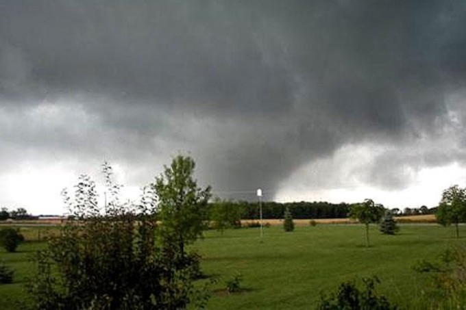
At the tip of that scorpion’s tail was the tornado, and it moved in from the northwest. From the shoreline at Goderich it appeared massive and ominous, a gigantic barrel-shaped cylinder with a sheath of rain and hail wrapping around the whipping, carousel of a storm. To the untrained eye of most residents it may have been hard to recognize that the huge, roiling column was in fact a tornado. The storm was fierce to be sure, but few could have looked out and realized that the monster over the lake was about to become the province’s most powerful tornado in fifteen years, and the most damaging since the disaster at Barrie in 1985.
At 3:48 pm, Environment Canada issued a tornado warning for Goderich, Bluewater, Southern Huron County and points east. The warning stated: “At 3:30pm EDT a severe thunderstorm is occurring over southern Lake Huron. This thunderstorm is moving to the southeast at 75km/h and will make landfall near Goderich about 4:00pm. This storm has a history of producing tornadoes”. For anybody who was listening, the forecasters at Environment Canada had provided a seven-minute warning.
At 3:55pm the tornado blasted into town. It first struck Indian Island on Goderich Harbor, ravaging the large industrial building complex of the Sifto Salt mine. Huge domes containing mountains of salt were torn apart. Office and warehouse buildings had their roofs ripped off and their brick walls crumbled. The towering salt evaporator was gutted and left skeletal. For the workers at the mine, the warning never came and, tragically, one man was killed as the tornado collapsed the boom of the crane he was operating.
Southeast of the mine, the tornado raced easily over a bluff and plowed into a neighborhood of homes. Trees were debranched, snapped and thrown, power poles were wrenched from the ground and their transformers exploded. Houses were shattered, many with their roofs ripped off and some losing their entire upper stories. Waterloo Street and St. George’s Crescent were hardest hit. From there the tornado advanced to strike the beautiful and historic downtown.
Downtown Goderich is organized around an octagonal town square, at the centre of which stands the beautiful-but-imposing town courthouse in the middle of its namesake park. Before August 21, 2011, tall old trees cast shade throughout the park and stately brick buildings dotted its perimeter, home to quaint merchant shops, cafes and restaurants, barbershops and bookshops. The square was the heart and pride of Goderich and the centre of civic gatherings. Indeed, until another storm earlier that afternoon cancelled the event, hundreds of people were in the square attending a bustling market. There is no telling how high the casualty count may have risen had that earlier deluge not compelled people out of the way of the impending disaster.
The tornado was at its largest and most intense as it slammed into the square. Every building around its perimeter, as well as the courthouse at its centre, was either severely damaged or destroyed. Windows were shattered and left with curtains and furniture dangling from them precariously, literally sucked out of them by the twister. Roofs and second storeys were torn away, brick facades crumbled and whole sections of buildings collapsed. Trees were snapped, uprooted and in some cases debarked, and cars were flipped and thrown. In the moments after the tornado passed, dazed residents emerged from buildings to a sea of debris; car alarms wailed and pieces of trees and buildings drifted down from the sky. The scope and severity of the devastation was immense and shocking.
From the square the tornado continued its rampage toward the southeast, blasting apart the Victoria Street United Church, a stunning heritage building that was completed in 1878. Located at the corner of Victoria Street North and St David Street, the church had its roof was torn off, leaving the internal beam structure jutting skyward like an exposed and mangled rib cage. The steeple was also blown away, and massive stained-glass windows exploded at either end of the building, leaving a gaping hole through its centre. It was later demolished.
Before the tornado exited Goderich, it ripped through several more blocks of houses on the east side of town. Homes were pock-marked and pierced by flying debris, sections of roofs were ripped off and, in some cases, walls collapsed. Trees were snapped and blown down, and cars were crushed and flipped over. Street after street suffered extensive damage.
Southeast of town, the tornado decimated tracts of forest as it travelled along the Maitland River before slicing through Morris Tract Provincial Nature Preserve. Here, it narrowed in size from the monstrous 1.5km-wide wedge it had been as it moved through Goderich, approaching Benmiller as a large and tapered stovepipe. Several buildings in the village suffered varying degrees of structural damage, including the Benmiller Inn. From there, the tornado tracked through rural areas as it continued to diminish in size and strength before finally dissipating to the southwest of Londesborough.
Thirty seven people were injured in Goderich and the tornado damage rated at F3, making this the most powerful tornado to strike Ontario since 1996. Not since the outbreak of May 31st 1985 had an Ontario town experienced such a devastating and direct hit from this powerful a tornado. Damage was estimated at over $150 million. This was one of two tornadoes to touch down on August 21, 2011.
The forecast
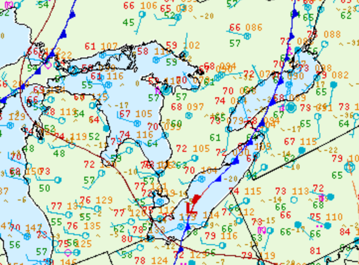
Figure 1 depicts the surface observations at 2:00 pm EDT, which shows a thunderstorm in the Bruce Peninsula and westerly flow coming off Lake Huron after the passage of a cold front. This would set the stage for lake-breeze boundaries to set up on the shores of Lake Huron. According to ECCC (2013), the severe weather season across southern Ontario was fairly quiet. However, a warm/humid airmass set the stage for severe weather on August 21st. A lake-breeze triggered thunderstorms off the shores of Lake Huron, which ultimately led to this historic and violent tornado in Goderich.
A severe thunderstorm watch was issued for Goderich at 2:02 pm EDT, which mentioned that a tornado was possible (Sills, n.d.). A tornado warning was issued for Goderich at 3:48 pm EDT with the saying ‘…moving southeast at 75 km/h and will make landfall near Goderich at 4:00 pm EDT’ (Sills, n.d.). The tornado struck Goderich at 3:55 pm, giving the residents a seven minute lead time to take cover.
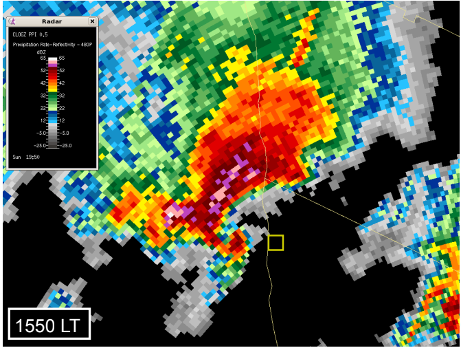
Figure 3 depicts a significant ‘hook echo’ feature, which is rarely seen in Canada. This hook echo put Goderich right in its path. The tornado was wrapped in rain as it made landfall and made it difficult to see. This tornado will be remembered for generations to come.
Sources
NWS Weather Prediction Center Surface Analysis Archive. (2017). Surface analysis 18Z Sun Aug 21 2011. Retrieved from: https://www.wpc.ncep.noaa.gov/archives/web_pages/sfc/sfc_archive.php
Environment and Climate Change Canada (ECCC). (2013). Canada’s Top Ten Weather Stories for 2011. Retrieved from https://www.ec.gc.ca/meteo-weather/meteo-weather/default.asp?lang=En&n=3A880EEA-1
Sills, D. (n.d.). Tornadoes in Canada: Improving our Understanding [PowerPoint slides]. https://www.iclr.org/wp-content/uploads/PDFS/SILLS_ICLR_Final.pdf