

According to Environment and Climate Change Canada, “fourteen tornadoes struck several Ontario communities, namely Barrie, Grand Valley, Orangeville and Tottenham. The Barrie tornado killed eight people. In all, the family of tornadoes injured hundreds of people, destroyed or damaged over 1,000 buildings and killed 12 people, tying it with the Pine Lake, AB tornado in 2000 as the fourth deadliest tornadic day in Canada. The Grand Valley tornado that began near Arthur and moved east to Campbellford is considered one of the longest tracked tornadoes in Canada, travelling over 115 km” (ECCC, 2017).
At about 4:15 pm, the third tornado of the day touched down just NW of Arthur. This tornado would go on to last for over an hour and trek more than 100 km across the heart of Southern Ontario. It would become the longest lasting tornado in Canadian history and leave behind a massive trail of death and destruction.
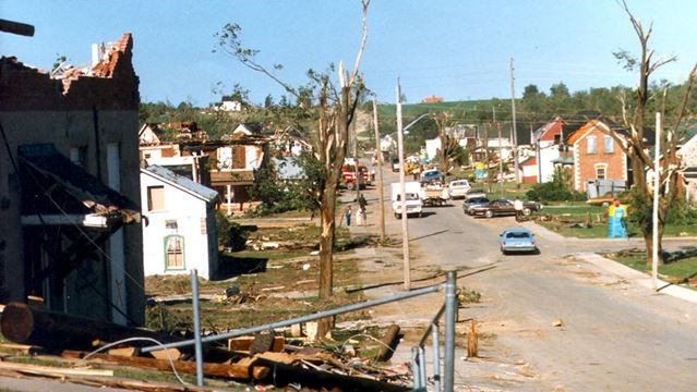
The tornado impacted several rural communities along its ruinous path from Arthur to Mouth Albert, but most notably struck was the town of Grand Valley, which took a direct hit. In it’s wake, part of the town resembled a bombed-out war zone with most of the buildings destroyed and once beautiful shade trees shredded. Unfortunately, there were also human losses as a man was killed in his pickup truck and a woman died when she was blown out of her house. Many others were injured to varying degrees. Some, including children barely escaped death as structures collapsed around them, luckily getting out with only minor injuries.
East of Grand Valley and a little less than half way through its lifespan, the tornado passed 4 km north of Downtown Orangeville. Here, as it crossed Highway 10 would it blast through an isolated strip mall known as the Mono Shopping Plaza. Half of the large two acre structure was reduced to a pile rubble with debris strewn hundred of meters downwind. Miraculously no one was killed in the mall but there were several injuries, with one of them being serious.
The tornado also struck dozens of rural residences and farms along it’s destructive path with the majority having to rebuild. One such community was the area south of Tottenham where sadly two other people were killed. Houses and outbuildings in this community were decimated with some being wiped clean off their foundations. In total, 25 families lost their homes in the Tottenham area alone.
After being on the ground for nearly an hour, the tornado crossed over Highway 400 on the north side of the Holland Marsh. Along the north canal, hundreds of large willow trees were mangled and strewn about by the ferocious winds. Agricultural properties in and along the marsh sustained heavy damage as well. Some of the destruction was severe enough for locals to rename one of the marsh roads to “Tornado Drive”.
It was only after crossing the marsh that the tornado began to show signs of weakening. In the communities of Ansnorveldt and East Gwillimbury, there was only moderate to minor damage reported. In Mount Albert, damage was sporadic and mostly confined to uprooted trees and other light structures being affected. However, it took another nine kilometres before the tornado was to lift off for good.
When it was all over, the impact of this monstrous tornado was staggering. After detailed ground and aerial surveys of the enormous area, officials concluded that the tornado had travelled a distance of 115 km. This was and still stands as a Canadian record. In total, over 100 buildings were found to be destroyed, 200 damaged. A minimum of 69 injuries were reported, and sadly four deaths occurred.
The Forecast
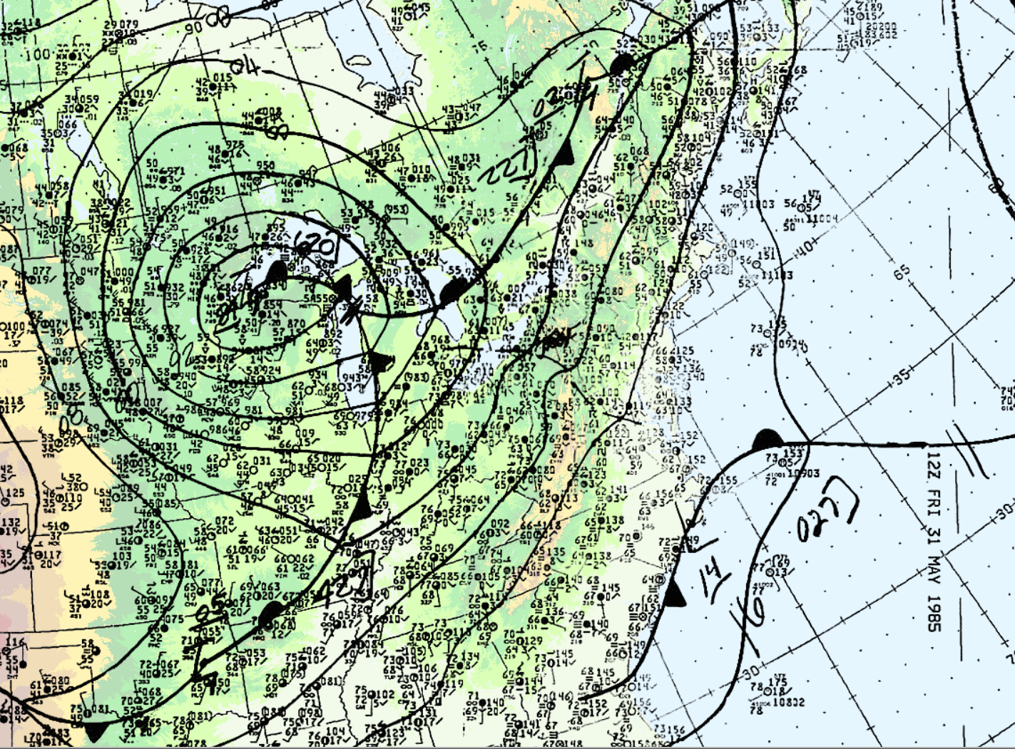
On the morning of May 31, 1985, warm air was advecting northward across Ontario. Figure 1 depicts the surface analysis on the morning of May 31st. In Figure 1, we can see a warm front advecting northward across Ontario and a cold front moving eastward (entering Michigan). The cold front would later provide the trigger for explosive supercell thunderstorm development. According to M. Leduc, O. Jacobsen and B. Greer (1986), “the morning analysis at Environment Canada’s Ontario Weather Centre (OWC) indicated that the thermodynamic and dynamic features necessary for the possible development of severe thunderstorms were present”. As a result, severe weather watches were issued at 2:40 am local time for Southern Ontario and extended for all of Southern Ontario at 7:00 am, 9:20 am and 1:50 pm, advising the population of potential severe thunderstorm development later in the day (Leduc et al., 1986).
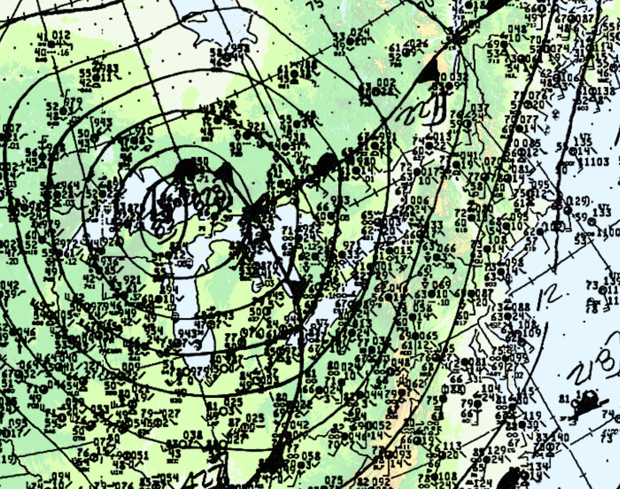
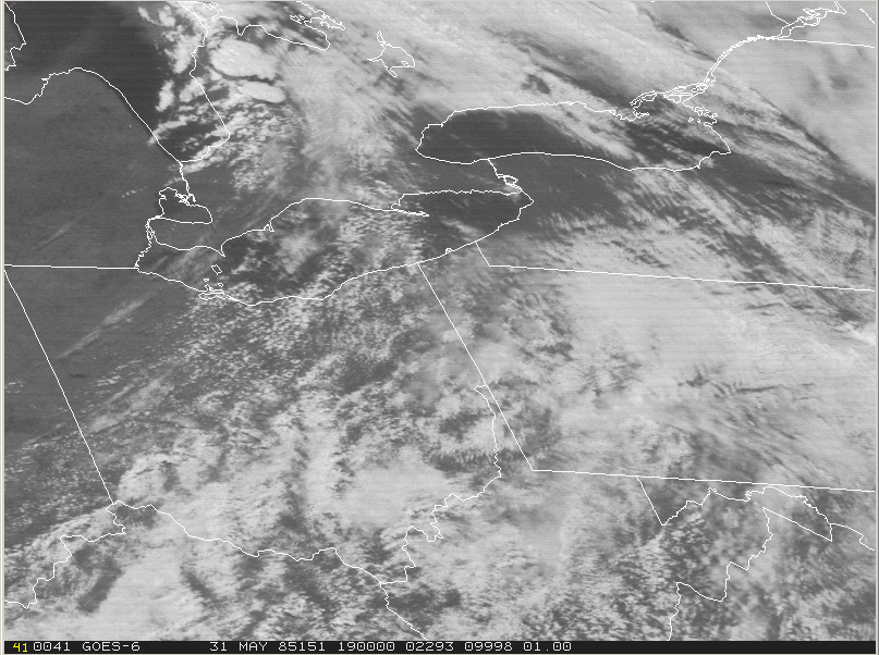
At 18Z (2:00 pm EDT), the cold front was entering Ontario (Figure 2). According to Leduc et al. (1986), an unseasonably strong low pressure centre tracked across Northern Michigan during the morning hours to just north of Sudbury by evening. The visible satellite loop below shows the development and explosive growth of thunderstorms across Southern Ontario, Ohio, Western Pennsylvania and Western New York on the afternoon of May 31st.
At 21Z (5:00 pm EDT), the cold front was in Western Ontario (Figure 4).
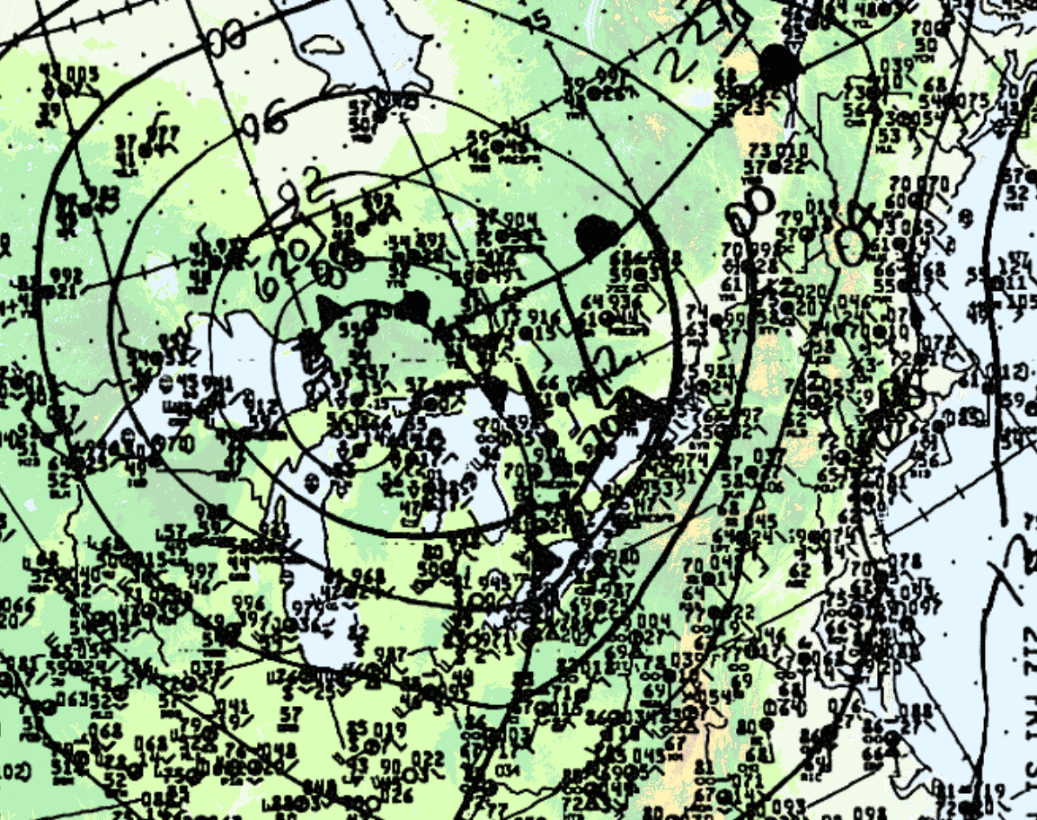
Leduc et al. (1986) notes that the dynamics in place were strong since a sharp cold front (Figure 1, 2 and 4) and an upper trough was crossing Michigan, bringing with it strong westerlies in the upper-levels of the atmosphere.
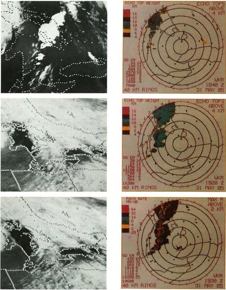
Figure 5 and 6 depict the radar imagery from the King City radar (north of Toronto). At 1:40 pm (local time), radar showed the first thunderstorms developing west and north of the Bruce Peninsula. By 2:20 pm, a line of severe storms was indicated by radar (Figure 5). The first severe thunderstorm warning was issued at 2:25 pm for the Bruce County and Parry Sound District. At 3:15 pm, severe thunderstorm warnings were issued for Huron, Perth, Grey, Northern Wellington and Northern Waterloo Counties, with the most intense storms being seen from Meaford to Perth County (Leduc et al., 1986). At 4:00 pm, reports of 2 cm hail and very high winds were received at the OWC for the Meaford and Dundalk area. Around 4:00 pm, radar showed a line of severe storms extending from Collingwood to Eastern Perth County moving east at 60-70 km/h (Figure 6).
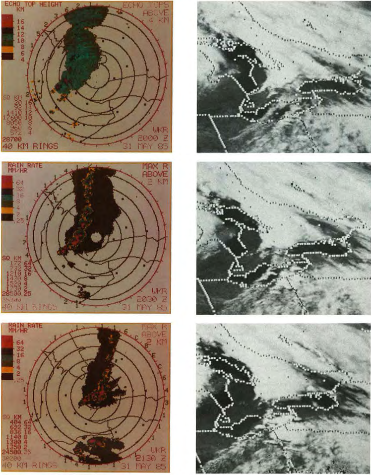
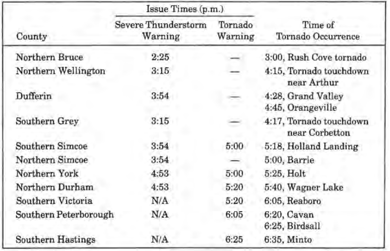
Between 4:20 pm and 4:40 pm, radar showed signs that the southern storms off the squall line were intensifying and therefore warnings were issued at 4:53 pm from Hamilton-Wentworth to Durham and Victoria counties. A tornado warning was issued at 5:00 pm for Southern Simcoe, Northern Peel and York counties after OWC received reports of a tornado at 5:00 pm and 5:20 pm. At 5:50 pm severe thunderstorm warnings were issued for the Niagara Peninsula. Tornado warnings were extended for Southern Durham and Peterborough counties at 6:05 pm and Haliburton, Northumberland, Prince Edward and Hastings counties at 6:25 pm. At 7:00 pm, warnings/watches were cancelled for all regions, except for Haliburton County and east of Oshawa where tornado reports southwest of Peterborough and Rawden Township were received between 6:40 pm and 7:20 pm. A timeline of tornado occurrence, severe thunderstorm warnings and tornado warnings are presented in Table 1 below.
The Aftermath


Recap
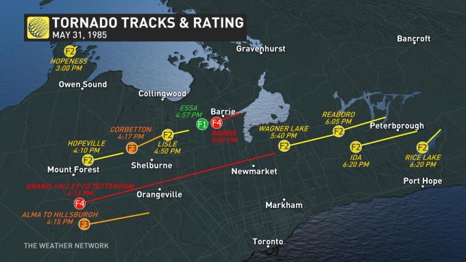
According to ECCC (2018), the Grand Valley to Tottenham F4 tornado touched down at 4:15 pm local time near Arthur, ON and tracked for 115 km through Grand Valley and Tottenham, moving in a east-northeasterly direction and ending over Mount Albert. The maximum width of the tornado was 600 metres. The F4 tornado killed 4 and injured 69. The total damage by this tornado was $2.5 million dollars (without inflation).
Sources
Environment and Climate Change Canada (2017). Top Weather Events of the 20th Century. Retrieved from: https://ec.gc.ca/meteo-weather/default.asp?lang=En&n=6A4A3AC5-1#tab5
NWS Weather Prediction Center (2017). North American Surface Analysis: Surface Analysis 12Z Friday May 31, 1985. Retrieved from: https://www.wpc.ncep.noaa.gov/html/sfc2.shtml
National Weather Service (2019). May 31, 1985 Tornado Outbreak: 34th Anniversary. Retrieved from: https://www.weather.gov/ctp/TornadoOutbreak_May311985#Meteorology
M. Leduc, O. Jacobsen and B. Greer (Winter 1986). The “Black Friday” Tornado Outbreak in Ontario. Chinook, 8, 13-18. Retrieved from: cmosarchives.ca/Chinook/ch0801.pdf
The Orangeville Banner (2019). Remembering the May 31, 1985 Grand Valley tornado: 16 people killed, hundreds injured, thousands left homeless across Ontario. Retrieved from: https://www.orangeville.com/news-story/9400602-remembering-the-may-31-1985-grand-valley-tornado-16-people-killed-hundreds-injured-thousands-left-homeless-across-ontario/
The Weather Network (2019). Massive Ontario tornado outbreak marks anniversary. Retrieved from: https://www.theweathernetwork.com/ca/news/article/anniversary-of-the-barrie-tornado-grand-valley-tottenham-may-31-1985-tornado-outbreak
Environment and Climate Change Canada (2018). Canadian National Tornado Database: Verified Events (1980-2009) – Public. Retrieved from: http://donnees.ec.gc.ca/data/weather/products/canadian-national-tornado-database-verified-events-1980-2009-public/?lang=en