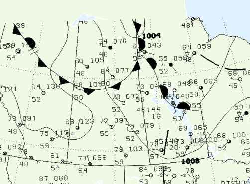
Figure 1 depicts the surface observations at 4:00 pm CDT, which shows a warm front across central Manitoba. This front became the focus for intense thunderstorms in the early afternoon hours of July 31st, which ultimately led to this long-track tornado.

According to Environment and Climate Change Canada (2018), an F0 tornado touched down at 4:40 pm CDT 14 km west-northwest of Guynemer, MB. The tornado travelled for 8 km, but its width was not documented by ECCC. The tornado caused no fatalities, injuries or documented property damage.
Sources
NWS Weather Prediction Center Surface Analysis Archive. (2017). Surface analysis 21Z Sat Jul 31 2004. Retrieved from: https://www.wpc.ncep.noaa.gov/archives/web_pages/sfc/sfc_archive.php
Environment and Climate Change Canada Data. (2018). Canadian National Tornado Database: Verified Events (1980-2009) – Public. Retrieved from: http://donnees.ec.gc.ca/data/weather/products/canadian-national-tornado-database-verified-events-1980-2009-public/

