

According to Environment and Climate Change Canada, “fourteen tornadoes struck several Ontario communities, namely Barrie, Grand Valley, Orangeville and Tottenham. The Barrie tornado killed eight people. In all, the family of tornadoes injured hundreds of people, destroyed or damaged over 1,000 buildings and killed 12 people, tying it with the Pine Lake, AB tornado in 2000 as the fourth deadliest tornadic day in Canada. The Grand Valley tornado that began near Arthur and moved east to Campbellford is considered one of the longest tracked tornadoes in Canada, travelling over 115 km” (ECCC, 2017).
Around 6:10 pm on May 31, about two hours after a strong tornado touched down in Alma, the supercell storm that produced it passed east about 30km north of Toronto through Durham Region. Continuing into the southern end of Victoria County, the storm became tornadic again, with a tornado touching down in the farming community of Lifford.
This new tornado passed mainly through open fields and other uninhabited lands north of Highway 7A for the first 14 km and passed over into Peterborough County. Here, a 75 metre-wide swath of maple bush was completely flattened southwest of the hamlet of Ida.
On the west side of County Road 10, one kilometre south of Ida and two kilometre north of Cavan, the tornado roared through, taking with it most of the roof of St. Johns Anglican Church. Gravestones in the church cemetery were blown over, and the church hall across the road had its entire roof removed and most of its concrete block walls collapsed.
As the tornado continued ENE between Ida and Springville, it tore through farm properties on the south side of Sharpe Line. A new large steel shed and well-built barn were destroyed at one residence, and immediately to the east, a 40×50 feet implement shed was flattened with a nearby barn damaged at a farming operation. In Springville, another farm suffered damage. There, a barn was destroyed, and the farmhouse and garage were tattered with many windows blown out. Large trees were uprooted were also uprooted along the tornado’s 150 metre-wide path.
From there, the tornado continued on its ENE course toward the Otonabee River, south of the city of Peterborough where only damage was done to trees. After crossing the river, it carried on for another 12km over mainly fields and bush before dissipating north of the village of Lang.
This tornado was originally rated F3, but was downgraded to F2 in 2005 due to lack of specifics in regard to the church hall’s construction.
The Forecast
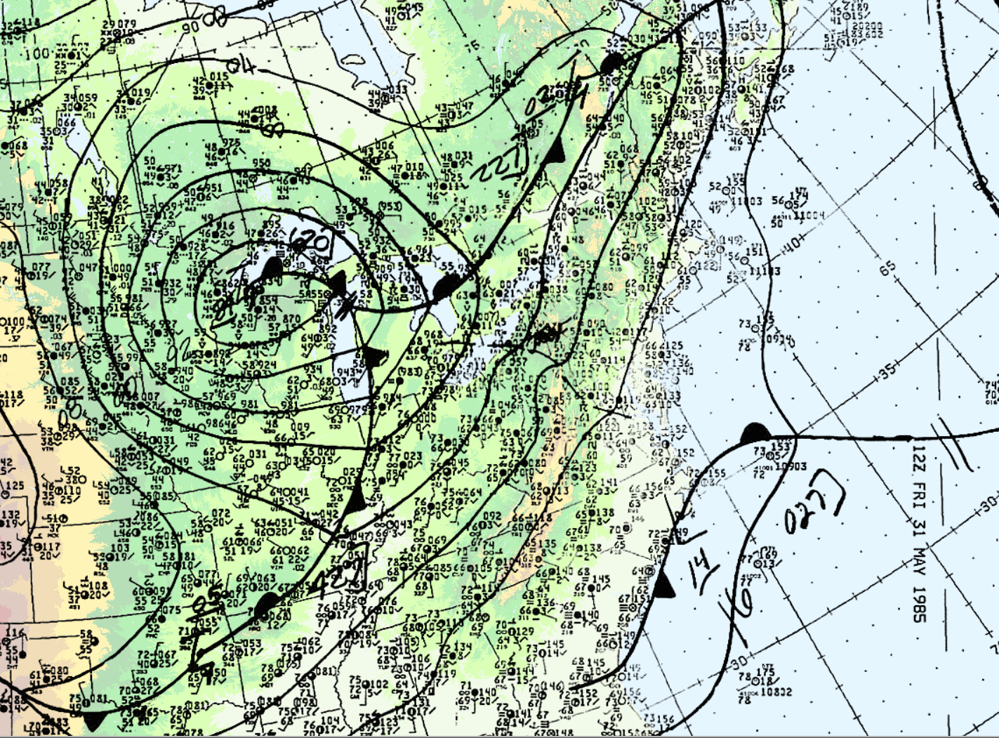
On the morning of May 31, 1985, warm air was advecting northward across Ontario. Figure 1 depicts the surface analysis on the morning of May 31st. In Figure 1, we can see a warm front advecting northward across Ontario and a cold front moving eastward (entering Michigan). The cold front would later provide the trigger for explosive supercell thunderstorm development. According to M. Leduc, O. Jacobsen and B. Greer (1986), “the morning analysis at Environment Canada’s Ontario Weather Centre (OWC) indicated that the thermodynamic and dynamic features necessary for the possible development of severe thunderstorms were present”. As a result, severe weather watches were issued at 2:40 am local time for southern Ontario and extended for all of southern Ontario at 7:00 am, 9:20 am and 1:50 pm, advising the population of potential severe thunderstorm development later in the day (Leduc et al., 1986).
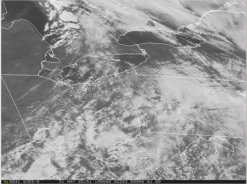
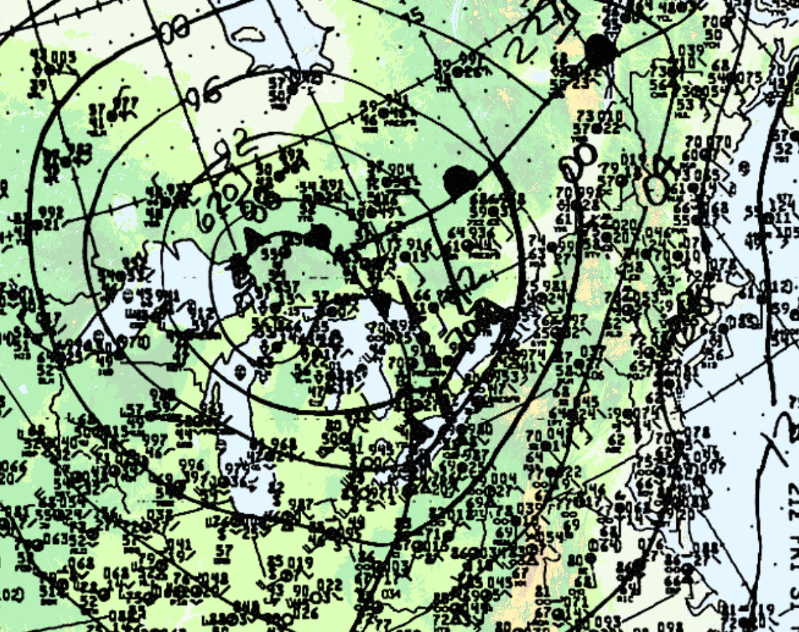
At 18Z (2:00 pm EDT), the cold front was entering Ontario (Figure 2). According to Leduc, et al. (1986), an unseasonably strong low pressure centre tracked across upper Michigan during the morning hours to just north of Sudbury by evening. The visible satellite loop below shows the development and explosive growth of thunderstorms across southern Ontario, Ohio, western Pennsylvania and western New York on the afternoon of May 31st.
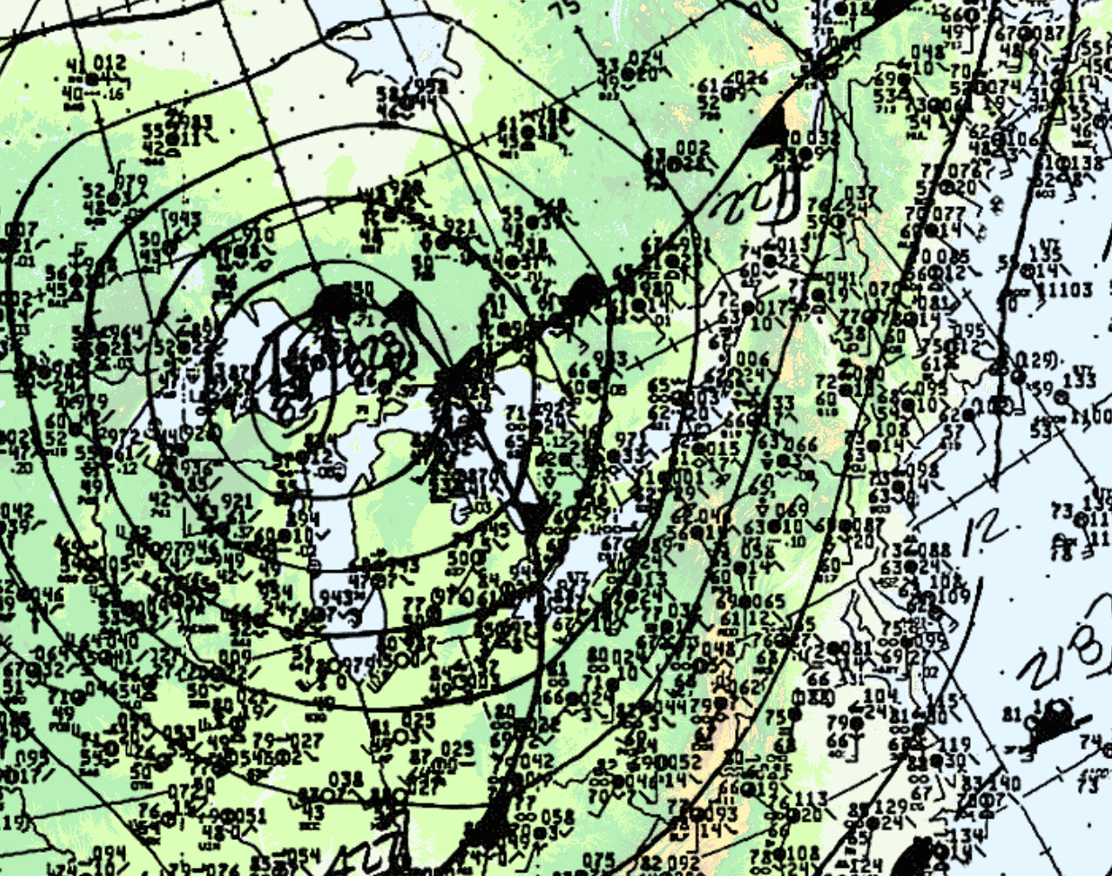
At 21Z (5:00 pm EDT), the cold front was in western Ontario (Figure 4).
Leduc et al. (1986) notes that the dynamics in place were strong since a sharp cold front (Figure 1, 2 and 4) and an upper trough was crossing Michigan, bringing with it strong westerlies in the upper-levels of the atmosphere.
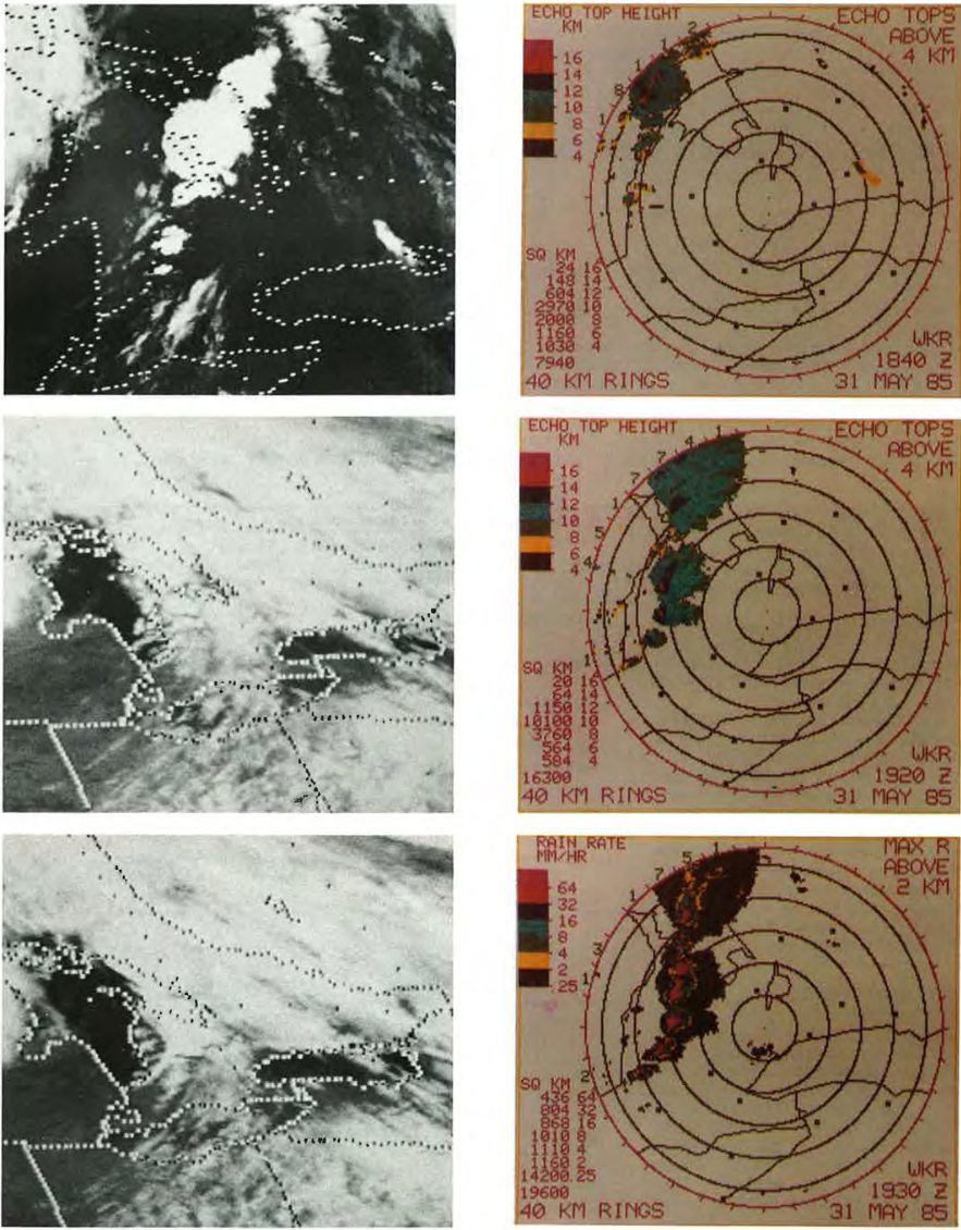
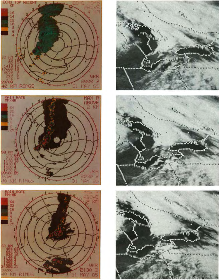
Figure 5 and 6 depict the radar imagery from the King City radar (north of Toronto). At 1:40 pm (local time), radar showed the first thunderstorms developing west and north of the Bruce Peninsula. By 2:20 pm, a line of severe storms was indicated by radar (Figure 5). The first severe thunderstorm warning was issued at 2:25 pm for the Bruce County and Parry Sound District. At 3:15 pm, severe thunderstorm warnings were issued for Huron, Perth, Grey, northern Wellington and northern Waterloo Counties, with the most intense storms being seen from Meaford to Perth County (Leduc et al., 1986). At 4:00 pm, reports of 2-cm hail and very high winds were received at the OWC for the Meaford and Dundalk area. Around 4:00 pm, radar showed a line of severe storms extending from Collingwood to eastern Perth County moving east at 60-70 km/h (Figure 6).
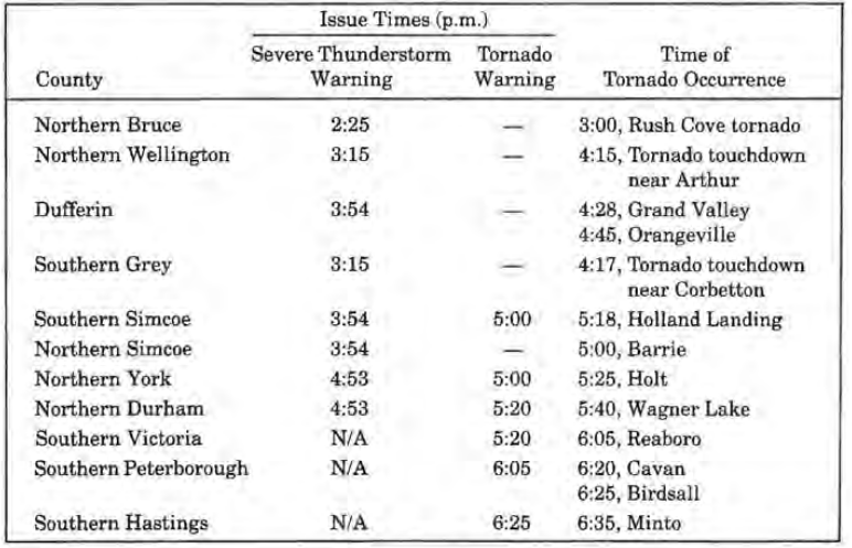
Between 4:20 pm and 4:40 pm, radar showed signs that the southern storms off the squall line were intensifying and therefore warnings were issued at 4:53 pm from Hamilton-Wentworth to Durham and Victoria counties. A tornado warning was issued at 5:00 pm for southern Simcoe, northern Peel and York counties after OWC received reports of a tornado at 5:00 pm and 5:20 pm. At 5:50 pm severe thunderstorm warnings were issued for the Niagara Peninsula. Tornado warnings were extended for southern Durham and Peterborough counties at 6:05 pm and Haliburton, Northumberland, Prince Edward and Hastings counties at 6:25 pm. At 7:00 pm, warnings/watches were cancelled for all regions, except for Haliburton County and east of Oshawa where tornado reports southwest of Peterborough and Rawden Township were received between 6:40 pm and 7:20 pm. A timeline of tornado occurrence, severe thunderstorm warnings and tornado warnings are presented in Table 1 below.
Recap
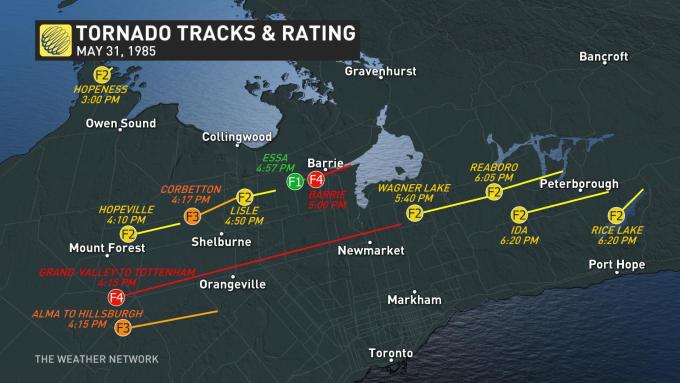
According to ECCC (2018), the Ida F2 tornado touched down at 6:20 pm local time near Lifford, ON and tracked for 38.6 km, moving in a east-northeasterly direction and impacting Ida, then ending southeast of Peterborough, near Hope Mill Conservation Area. The maximum width of the tornado was not documented. ECCC (2018) did not catalogue any injuries, fatalities or damage associated with this tornado.
Sources
Environment and Climate Change Canada (2017). Top Weather Events of the 20th Century. Retrieved from: https://ec.gc.ca/meteo-weather/default.asp?lang=En&n=6A4A3AC5-1#tab5
NWS
Weather Prediction Center (2017). North American Surface Analysis:
Surface Analysis 12Z Friday May 31, 1985. Retrieved from: https://www.wpc.ncep.noaa.gov/html/sfc2.shtml
National Weather Service (2019). May 31, 1985 Tornado Outbreak: 34th Anniversary. Retrieved from: https://www.weather.gov/ctp/TornadoOutbreak_May311985#Meteorology
M. Leduc, O. Jacobsen and B. Greer (Winter 1986). The “Black Friday” Tornado Outbreak in Ontario. Chinook, 8, 13-18. Retrieved from: cmosarchives.ca/Chinook/ch0801.pdf
The Weather Network (2019). Massive Ontario tornado outbreak marks anniversary. Retrieved from: https://www.theweathernetwork.com/ca/news/article/anniversary-of-the-barrie-tornado-grand-valley-tottenham-may-31-1985-tornado-outbreak
Environment
and Climate Change Canada (2018). Canadian National Tornado
Database: Verified Events (1980-2009) – Public. Retrieved from: http://donnees.ec.gc.ca/data/weather/products/canadian-national-tornado-database-verified-events-1980-2009-public/?lang=en