

Elie, MB tornado
On the evening of June 22, 2007, a small town west of Winnipeg was about to become the focal point of a historic event. Elie, Manitoba is a small community roughly 30 minutes west of Winnipeg and is located along the Trans-Canada Highway. According to McCarthy, Carlsen & Slipec (2008), the preliminary damage assessment of the Elie tornado had it as F4 strength. However, after further assessment and correlation with photograph/video evidence, the rating of F5 was given to the Elie tornado, making it Canada’s first and only F5 tornado on record.
According to Environment and Climate Change Canada (ECCC) (2017), “the tornado picked up an entire house and carried it a few hundred metres through the air, where it exploded. Winds pushed two semi-trailers off the highway, leaving one truck twisted like a pretzel a few hundred metres away in the middle of a field”.
What made this tornado so unique?
According to Hobson (2011), the Manitoba Escarpment and the Gunton Bedrock Escarpment had a role in triggering convective storms on June 22, 2007. Furthermore, Elie sits at the base of Lake Winnipeg and Lake Manitoba where temperature and wind direction changes can occur on the east and south of said lakes. Hobson (2011) speculates that lake-breeze interactions as well as geographical enhancement may have contributed to the exceptional Elie F5 tornado. Hobson (2011) goes on by stating that the Elie tornado was unique in the sense that it didn’t behave like most tornadoes. The Elie tornado did not cycle like most tornadoes tend to do and it remained on the ground for nearly 40 minutes (Hobson, 2011). The size of the funnel was also quite small compared to similar tornadoes of its caliber.
According to ECCC (2018), the Elie tornado was:
– 4.33 km path length;
– 300 metres maximum width;
– zero fatalities and serious injuries.
All of this made the Elie tornado quite unique. However, only by diving deeper into the forecasting and precursors of the Elie tornado can one really appreciate how exceptional this day truly was. All the parameters needed for the strongest winds on Earth came into play and converged on this poor little town called Elie.
Forecast of June 22, 2007
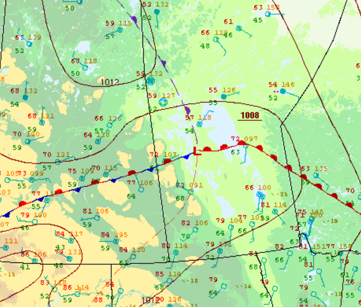
Figure 2 depicts the surface analysis in the early afternoon of June 22nd. This analysis depicts a typical severe weather “setup” for southern Manitoba with an ejecting low pressure and its associated cold/warm fronts. The Prairie and Arctic Storm Prediction Centre in Winnipeg launched a weather balloon at 18Z or 1:00 pm CDT (see below).
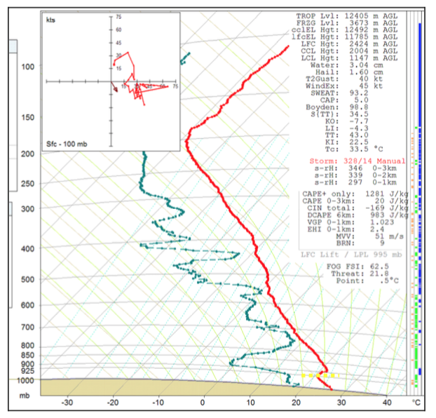
Figure 3 depicts a vertical profile of the atmosphere in Winnipeg, MB at 1:00 pm CDT on June 22nd. This depicts LCL heights of 1.1 km and only 1281 J/kg of CAPE, a measure of instability. The LCL heights in this sounding would indicate why the Elie tornado was so high based. Surface temperatures are observed in the 30C range across the warm sector (southern Manitoba).
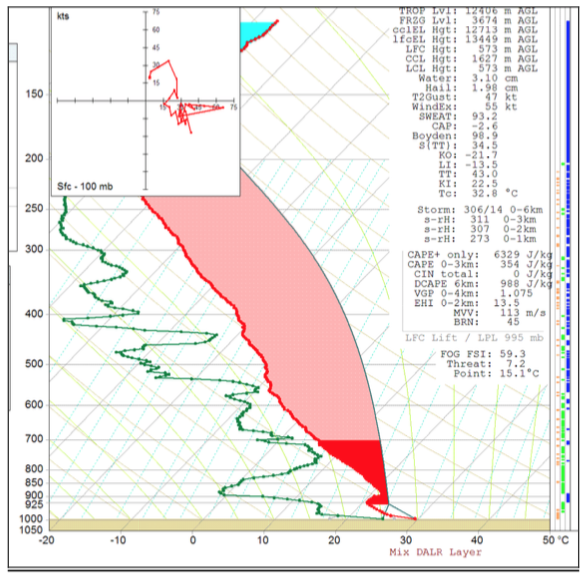
While the sounding of Figure 3 doesn’t seem particularly prone to tornadoes, it all changes when one looks at the sounding generated in Carman, MB (Figure 4). Carman is roughly 45 km south-southwest of Elie. Considering warm air advection was occurring from the southwest (towards Elie), the environment in Elie could have been very similar to the sounding observed in Carman at 6:00 pm CDT. This sounding depicts extreme instability at 6329 J/kg and high storm relative helicity (SRH) in 0-1km of 273, more than supportive of strong tornadoes. Convective inhibition (CIN) is noted as 0, therefore the capping inversion is no longer present, allowing for convection to develop. Energy helicity index (EHI) 0-2 km is also very high with a 13.5 value. Very rarely do Manitoba see these type of numbers.
At 4:40 pm CDT, the cold front moved southeast, crossing Lake Manitoba and a lake-breeze boundary is observed (Figure 5) just on the southeast side of Lake Manitoba.
According to Hobson (2011), at 5:00 pm CDT, gravity waves were located 36 km to the SW of Woodlands and originating from the Manitoba Escarpment. Hobson (2011) speculates that the gravity waves moved northeast where they began interacting with horizontal convective rolls (HCRs) ahead of the lake-breeze boundary. The associated lift generated by gravity waves and the Gunton Bedrock Escarpment and the HCRs interacting with low-level moisture triggered convection at 5:10 pm CDT (Hobson, 2011).
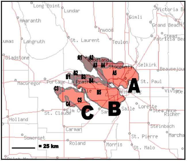
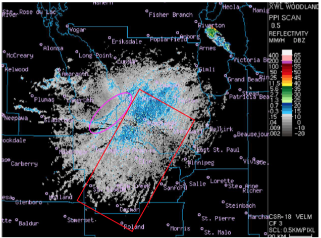
Figure 6 depicts supercells that impacted southern Manitoba on June 22nd. The supercell marked with “B” is the one responsible for dropping the Elie F5 tornado. A well-defined “hook-echo” can be observed over Elie at B4 (2340Z) from Figure 6.
Recap
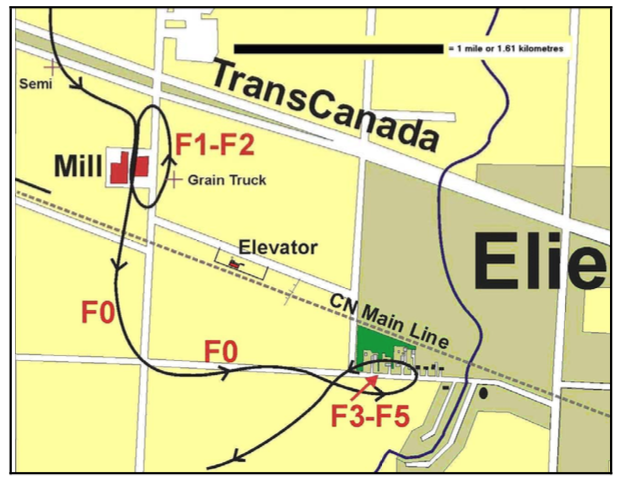
According to ECCC (2017), on June 22, 2007, a tornado touched down at 6:25 pm local time just north of the Trans-Canada Highway near Elie, MB (Figure 1). The tornado was 300 metres wide, stayed on the ground for about 35 minutes and tracked about 4.33 km. Top wind speeds were between 420 km/h and 510 km/h. No fatalities or significant injuries were observed from this tornado. The damage done by the Elie tornado was not catalogued by ECCC.
Sources
McCarthy, P. J., Carlsen, D. & Slipec, J. (2008). Elie, Manitoba, Canada, June 22. 2007: Canada’s First F5 Tornado. Paper presented at 24th Conference on Severe Local Storms.
Environment and Climate Change Canada (2017). Top ten weather stories of 2007: story ten. Retrieved from: https://ec.gc.ca/meteo-weather/default.asp?lang=En&n=07580648-1
Hobson, J. J. (2011). Meteorological Analysis of the 22 June 2007 F5 Tornado in Elie, Manitoba (unpublished master’s thesis). University of Manitoba, Winnipeg, Manitoba, Canada
NWS Weather Prediction Center Surface Analysis Archive. (2017). Surface analysis 18Z Fri Jun 22 2007. Retrieved from: https://www.wpc.ncep.noaa.gov/archives/web_pages/sfc/sfc_archive.php
Environment and Climate Change Canada (2018). Canadian National Tornado Database: Verified Events (1980-2009) – Public. Retrieved from: http://donnees.ec.gc.ca/data/weather/products/canadian-national-tornado-database-verified-events-1980-2009-public/?lang=en