

The same supercell that produced the Dryden tornado went on to produce this other F1 to the northeast near Lac Seul. Its path was 12 km long and 400m wide, with a swath of forest destroyed. Witnesses watched and took photos and video from lakeside cottages as the cone tornado touched down and then morphed into a large stovepipe. This was one of four tornadoes that touched down on August 16, 2011.
Methods for tornado track
Based on this video, which is believed to be taken from Kejick Bay, ON, we used satellite imagery to estimate the path and width of the tornado based on visible tree damage. It is believed that the viewer is looking east at the beginning of the video and therefore the tornado developed southeast of Kejick Bay on another island, where tree damage was found. The viewer then moves the camera east-northeast toward the large cone tornado, which we estimate to be over Cow Island. This is where the tornado was likely at its widest and strongest. The track is almost impossible to follow passed Cow Island as it goes over water and the video ends. However, the tornado seems to have widen significantly to an approximate 300 metres wide as it was leaving the northern edge of Cow Island. The track was extrapolated to the nearby island as the tornado seemingly makes a right turn. Some circular damage seems present on the island east of Cow Island and then erratic tree damage seem present. This could be explained by the tornado lifting. By extrapolating the track northeast to another nearby island, there seems to be an obvious linear pattern in the trees, which was assumed to be tornado damage, which ends at latitude 50.3141 N and longitude -92.1958 E. However, this could also be due to underlaying ground features that is not perceptible by satellite. This puts the estimated total length of this tornado at 8.3 kilometres.
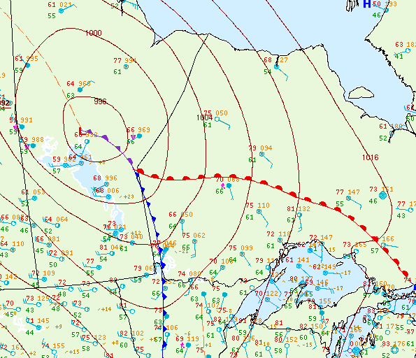
Figure 1 depicts the surface observations at 4:00 pm EDT, which shows an occluding low pressure in northern Manitoba, bringing a cold front near the ON/MB border and a warm front in northwestern Ontario. The warm front became the focus for intense thunderstorms throughout the afternoon and evening hours, which ultimately led to four tornadoes across northwestern Ontario on this day.
Sources
NWS Weather Prediction Center Surface Analysis Archive. (2017). Surface analysis 21Z Tue Aug 16 2011. Retrieved from: https://www.wpc.ncep.noaa.gov/archives/web_pages/sfc/sfc_archive.php