

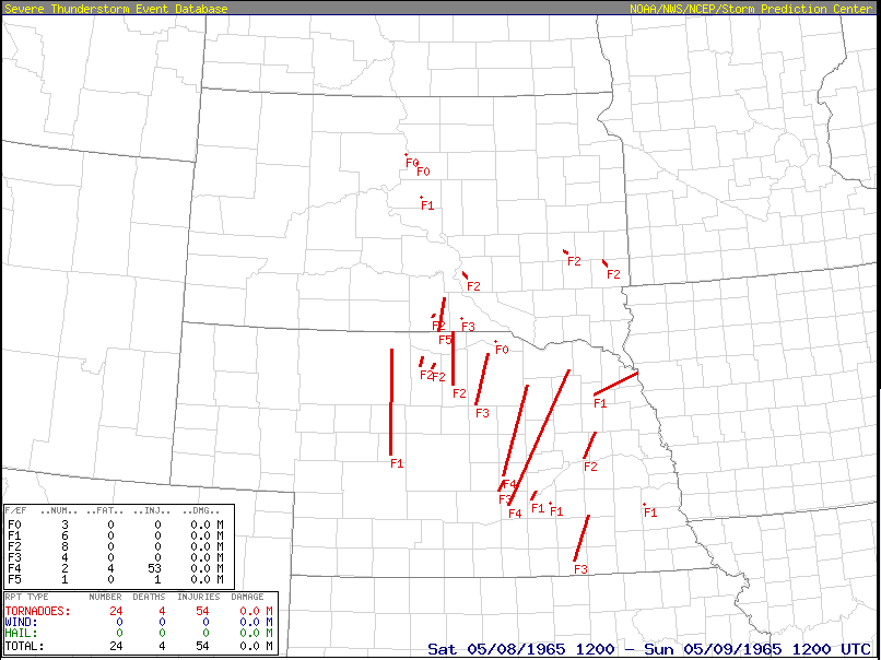
On May 8, 1965, a tornado outbreak impacted parts of South Dakota and Nebraska, with up to 30 tornadoes being reported. Figure 1 (below) depicts the extent of the outbreak across the United States. The strongest tornado was and F5 in Tripp County, SD. This is the state’s only recorded F5/EF5 tornado (National Weather Service, 2019).
The Forecast
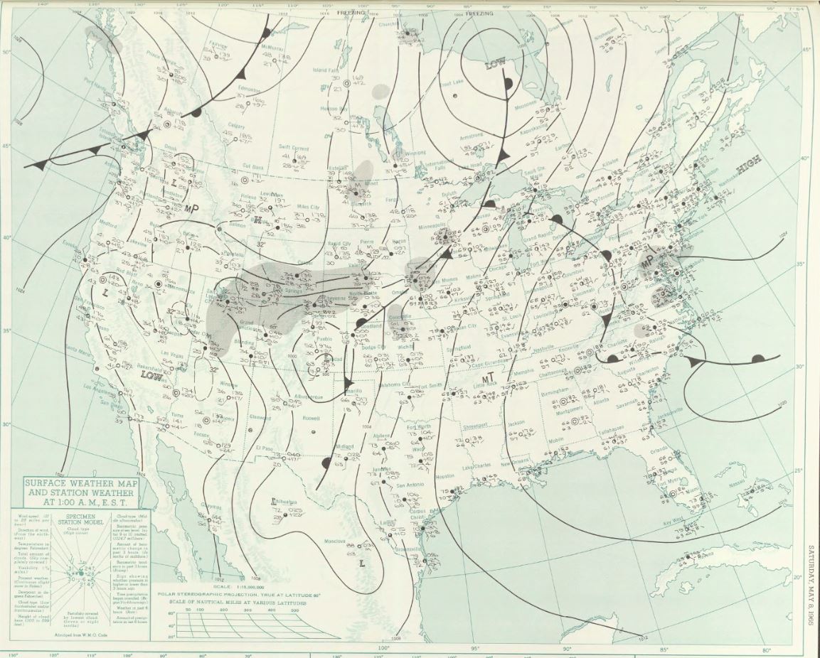
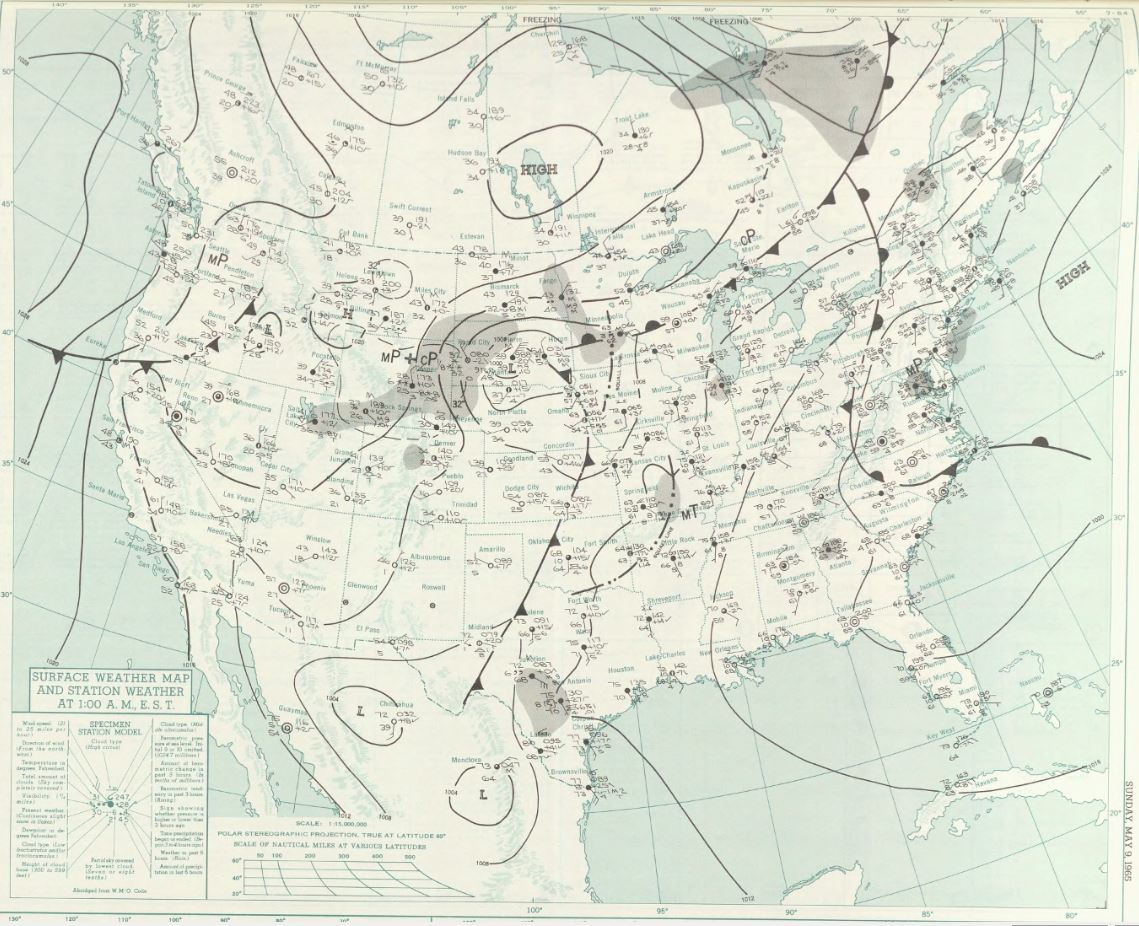
Figure 2 and 3 depict the surface analysis for the day of May 8th. In Figure 1, a strong Colorado low is seen developing. Figure 1 is 17-18 hours prior to tornadoes. Figure 2 is 6-7 hours after the tornadoes. This was due to sparse observational data. The National Weather Service only received surface maps at midnight each day (NWS, 2019).
As the low moved north-northeast, Tripp County, SD became in the warm sector where warm moist and unstable air moved into the county. According to the National Weather Service (2019), balloon data was extrapolated between Rapid City, SD and North Platte, NE to produce the sounding in Figure 4.
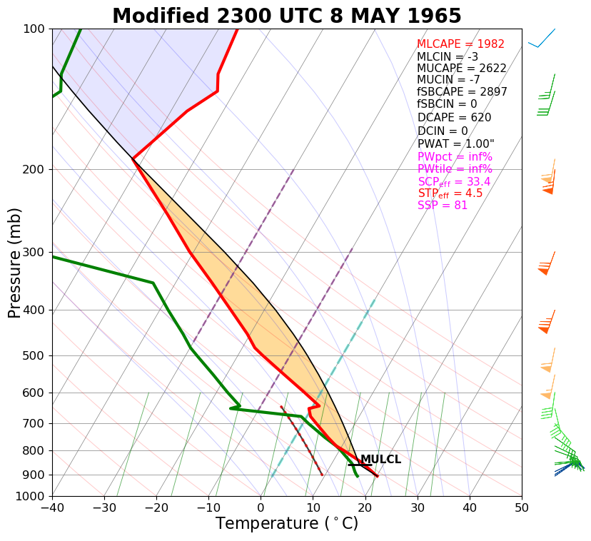
“The resulting sounding suggests that a very unstable air mass with strong vertical wind shear was in place. This is a classic setup for major tornado outbreaks” (NWS, 2019).
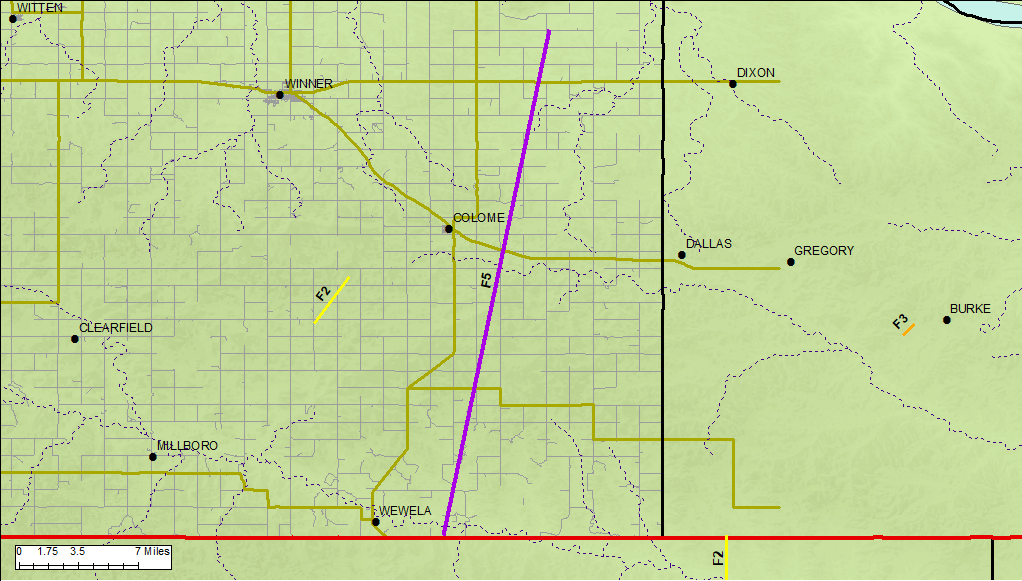
According to NOAA’s storm event database (2019), the Tripp County F5 tornado (depicted in Figure 5) began at 5:15 pm CST, had a path length of 30.1 miles, maximum width of 1760 yards, injured one person and caused $2.5 Million in damage. Estimated wind speeds were higher than 200 mph (NWS, 2019). Another tornado occurred in Tripp County on this day, shown in Figure 6.
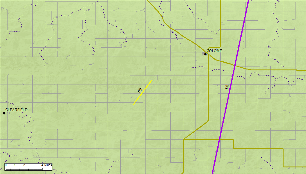
According to NOAA’s storm event database (2019), the Tripp County F2 tornado (depicted in Figure 6) began at 5:23 pm CST, had a path length of ~3 miles, maximum width of 20 yards and caused no injuries/deaths/property damage. Estimated wind speeds were higher than 110 mph (NWS, 2019).
Tornado Damage
Below is a compilation by the National Weather Service Rapid City, SD of reported damage from the tornado:
“Although reports of additional tornado and wind damage are still coming in, a list of victims and damages has been compiled by Sheriff Storms. Included in the list of victims are twenty-seven areas both in Tripp County and Nebraska which were hit by the twisters. The most severe tornado apparently touched down south east of Wewela in Nebraska and then followed a ravine for over fifteen miles north across Highway 118. A second twister apparently touched down about ten miles south of Winner to hit several farms in that area. Damage at the Tom Holden farm south of Winner included a total loss of all out buildings and severe damage to the house. Mr. and Mrs. Holden and their two grandchildren were in the home at the time of the storm while a son, Merle, was tossed about in a car as he drove into the yard when the storm hit” (NWS, 2019).
“Other damage in this area included wind damage to the out buildings on the Joe Holden farm and lesser damage to outbuildings on the William Hahn and Maurice Steele farms. The barn on the Vernon Herrmann farm, south-east of Millboro also received some damage to fences, trees and telephone lines near the Nelson Smith farm in this area. The largest of the two twisters apparently touched down near the John Van Heeder farm in Nebraska where the storm leveled the entire farmstead, including the house. Mrs. Von Heeder and a baby were in the house at the time but were not injured. As the storm moved into Tripp County it destroyed a sheep barn and killed one calf on the Erv Croston farm. The trail of destruction continued through the Otto Hauf farmstead completely demolishing the farm including the Hauf house and a vacant set of buildings just across the road. Mr. and Mrs. Hauf had driven into Winner and luckily were not at home when the twister hit. Just a mile north of the Hauf farm, the tornado leveled the farm of Kenneth Kenzy, destroying the Kenzy home and surrounding outbuildings. Mr. Kenzy was able to escape the fury of the storm when his father-in-law saw the twister approaching and was able to drive away with the Kenzy family before it hit. Mrs. Kenzy was not at home at the time. The farm buildings on the Howard Sorber farm, two miles north of the Kenzy farm, were completely leveled while Mrs. Sorber and her three grandchildren remained in one of the two houses which withstood the tornadic blast. The damaging twister continued up eastern Tripp County leveling a granary and corn crib on the Dennis DeMers farm. Continuing north the tornado completely destroyed the outbuildings on the William Musilek farm injuring Mr. Musilek who was driving home in his auto at the time. Other members of the Musilek family sought protection from the storm in the basement of the house which was severely damaged and is considered a total loss by authorities. The farm of James and Phillip Musilek, located three miles east of the William Musilek farm, received severe damage when outbuildings and fences were torn down. A trailer house on this farm was also twisted from its moorings. Additional damage was reported to the Donald Kaiser farm near the Musilek place where several outbuildings were lost and a vacant farmstead was completely demolished. The outbuildings of the Phil Shadeed farm near the Kaiser place were also demolished. A pole barn at the Charles Hrabanek farm south and east of the Calvary Chapel was picked up by the twister and deposited in a heap neat the Hrabanek house. The entire set of outbuildings at the Harley Fetzer farm were completely wiped out by the storm as Mr. Fetzer was thrown from his auto by the violence of the twister. He was not injured in the incident. Local authorities stated that the Fetzer house was also severely damaged. Other buildings which were demolished in the storm’s fury included all the outbuildings on the farmsteads of Ray Neyens, Bill Donovan, Leonard Vobr and Bern Bertram” (NWS, 2019).
“In a final gust of fury before leaving the scene of violence, the twister completely demolished all the outbuildings on the Joe Stritecky farm north east of Colome. The Stritecky family took refuge in a cave while the storm was in progress. The Stritecky home was also severely damaged by the storm. Local authorities have not yet been placed an estimate on the total amount of damage caused by the twister and speculated that this tornado may have been the same one seen in the Hamill area which caused some minor damage” (NWS, 2019).
After the tornadoes
Typical of Colorado lows in spring, cold air advection was taking place in the west/northwest side of the low. With moisture wrapping around the low pressure, significant snowfall was observed. According to the NWS (2019), 8.8 inches was observed at Rapid City Airport, while Lead, SD reported 36 inches of snow.
Source
National Weather Service (2019). May 8, 1965 Tripp County F5 Tornado. Retrieved from: https://www.weather.gov/unr/1965-05-08
NOAA National Centers for Environmental Information (2019). Storm Events Database. Retrieved from: https://www.ncdc.noaa.gov/stormevents/