

Forecast of June 22, 2007
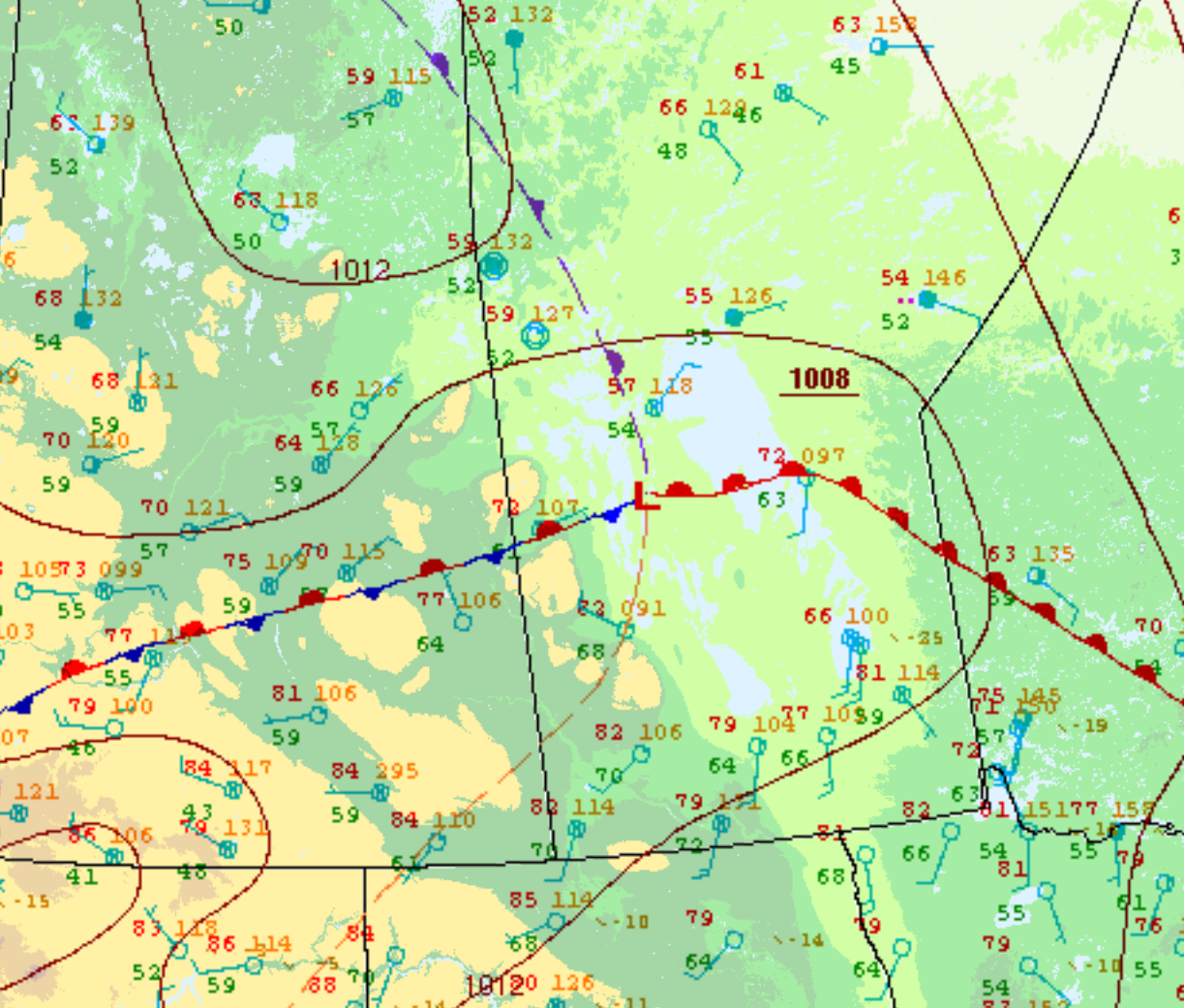
Figure 2 depicts the surface analysis in the early afternoon of June 22nd. This analysis depicts a typical severe weather “setup” for southern Manitoba with an ejecting low pressure and its associated cold/warm fronts. The Prairie and Arctic Storm Prediction Centre in Winnipeg launched a weather balloon at 18Z or 1:00 pm CDT (see below).
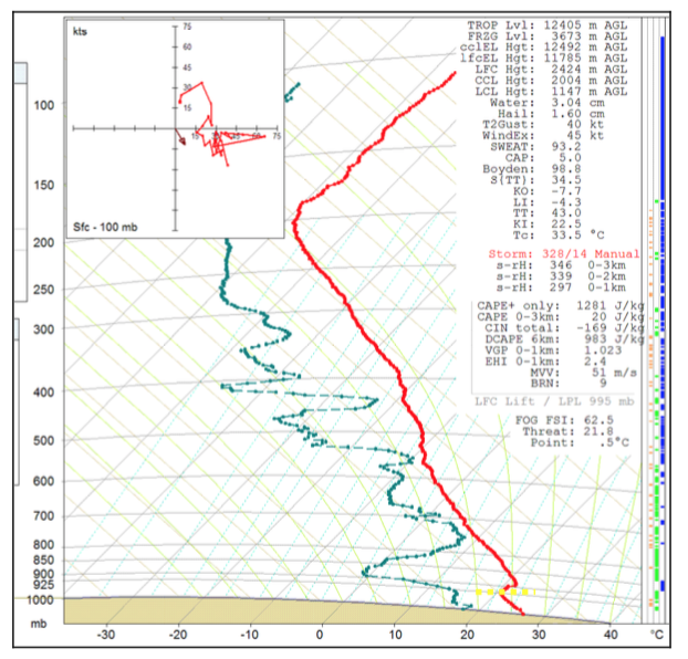
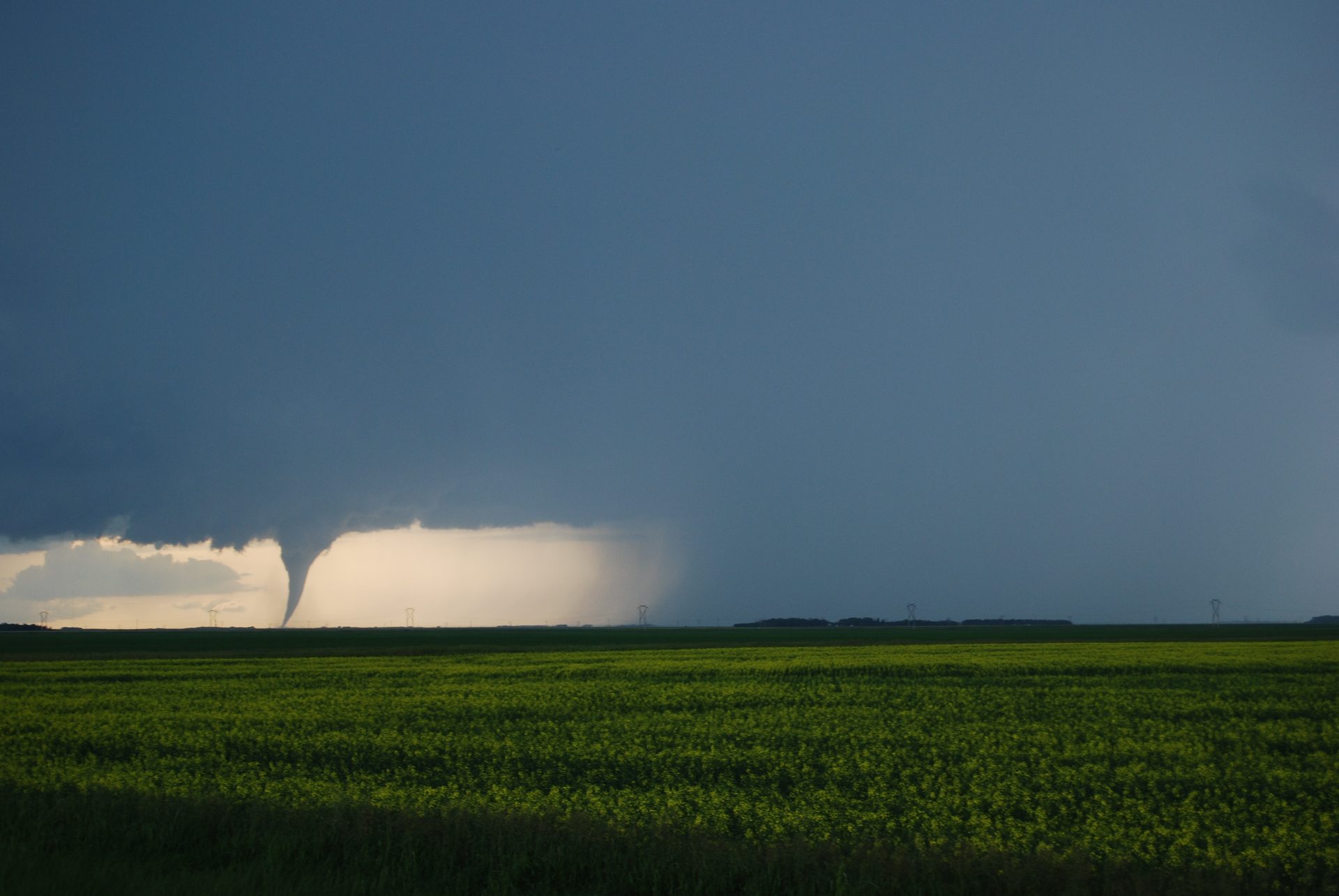
Figure 3 depicts a vertical profile of the atmosphere in Winnipeg, MB at 1:00 pm CDT on June 22nd. This depicts LCL heights of 1.1 km and only 1281 J/kg of CAPE, a measure of instability. The LCL heights in this sounding would indicate why the Elie tornado was so high based. Surface temperatures are observed in the 30C range across the warm sector (southern Manitoba).
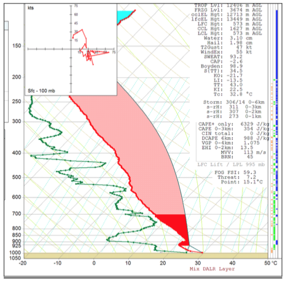
While the sounding of Figure 3 doesn’t seem particularly prone to tornadoes, it all changes when one looks at the sounding generated in Carman, MB (Figure 4). Carman is roughly 45 km south-southwest of Elie. Considering warm air advection was occurring from the southwest (towards Elie), the environment in Elie could have been very similar to the sounding observed in Carman at 6:00 pm CDT. This sounding depicts extreme instability at 6329 J/kg and high storm relative helicity (SRH) in 0-1km of 273, more than supportive of strong tornadoes. Convective inhibition (CIN) is noted as 0, therefore the capping inversion is no longer present, allowing for convection to develop. Energy helicity index (EHI) 0-2 km is also very high with a 13.5 value. Very rarely do Manitoba see these type of numbers.
At 4:40 pm CDT, the cold front moved southeast, crossing Lake Manitoba and a lake-breeze boundary is observed (Figure 5) just on the southeast side of Lake Manitoba.
According to Hobson (2011), at 5:00 pm CDT, gravity waves were located 36 km to the SW of Woodlands and originating from the Manitoba Escarpment. Hobson (2011) speculates that the gravity waves moved northeast where they began interacting with horizontal convective rolls (HCRs) ahead of the lake-breeze boundary. The associated lift generated by gravity waves and the Gunton Bedrock Escarpment and the HCRs interacting with low-level moisture triggered convection at 5:10 pm CDT (Hobson, 2011).
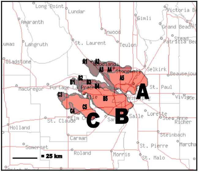
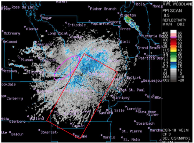
Figure 6 depicts supercells that impacted southern Manitoba on June 22nd. The supercell marked with “B” is the one responsible for dropping the Elie F5 tornado. A well-defined “hook-echo” can be observed over Elie at B4 (2340Z) from Figure 6.
Recap
According to Environment and Climate Change Canada (2018), an F3 tornado touched down at 6:55 pm CDT near Oakville, MB. The path of the tornado was not documented by ECCC, but the tornado had a maximum width of 200 metres. No property damage was documented for this tornado.
Sources
University of Manitoba. (2007). The Elie and Oakville tornado pictures from June 22, 2007 [Image]. Retrieved from http://www.umanitoba.ca/environment/envirogeog/weather/eliepics.html
NWS Weather Prediction Center Surface Analysis Archive. (2017). Surface analysis 00Z Thu Jun 14 2007. Retrieved from: https://www.wpc.ncep.noaa.gov/archives/web_pages/sfc/sfc_archive.php
McCarthy, P. J., Carlsen, D. & Slipec, J. (2008). Elie, Manitoba, Canada, June 22. 2007: Canada’s First F5 Tornado. Paper presented at 24th Conference on Severe Local Storms.
Environment and Climate Change Canada (2017). Top ten weather stories of 2007: story ten. Retrieved from: https://ec.gc.ca/meteo-weather/default.asp?lang=En&n=07580648-1
Hobson, J. J. (2011). Meteorological Analysis of the 22 June 2007 F5 Tornado in Elie, Manitoba (unpublished master’s thesis). University of Manitoba, Winnipeg, Manitoba, Canada
Environment and Climate Change Canada Data. (2018). Canadian National Tornado Database: Verified Events (1980-2009) – Public. Retrieved from: http://donnees.ec.gc.ca/data/weather/products/canadian-national-tornado-database-verified-events-1980-2009-public/