

According to the National Weather Service (NWS) in Chicago, IL (2015), the Plainfield tornado was the first ever tornado greater than an F3 rating, since records began in 1950, to occur during the month of August in the state of Illinois. As of 2015, it remains the only F5/EF5 rated tornado documented in the United States during the month of August. The tornado had low clouds and rain surrounding it, making it difficult to see. Because of this, no known photographs or videos of this tornado exist. This tornado approached from the northwest, which was unusual since most tornadoes approach from the southwest.
According to the National Climatic Data Center (1990), “the surprise factor was great with this tornado because a powerful thunderstorm was in progress with low cloud bases. Therefore, the early stages of the tornado were masked by the preceding downburst. Eyewitness accounts testify to abrupt and complete devastation where people were unable to communicate the danger to others until it was too late”.
The Forecast
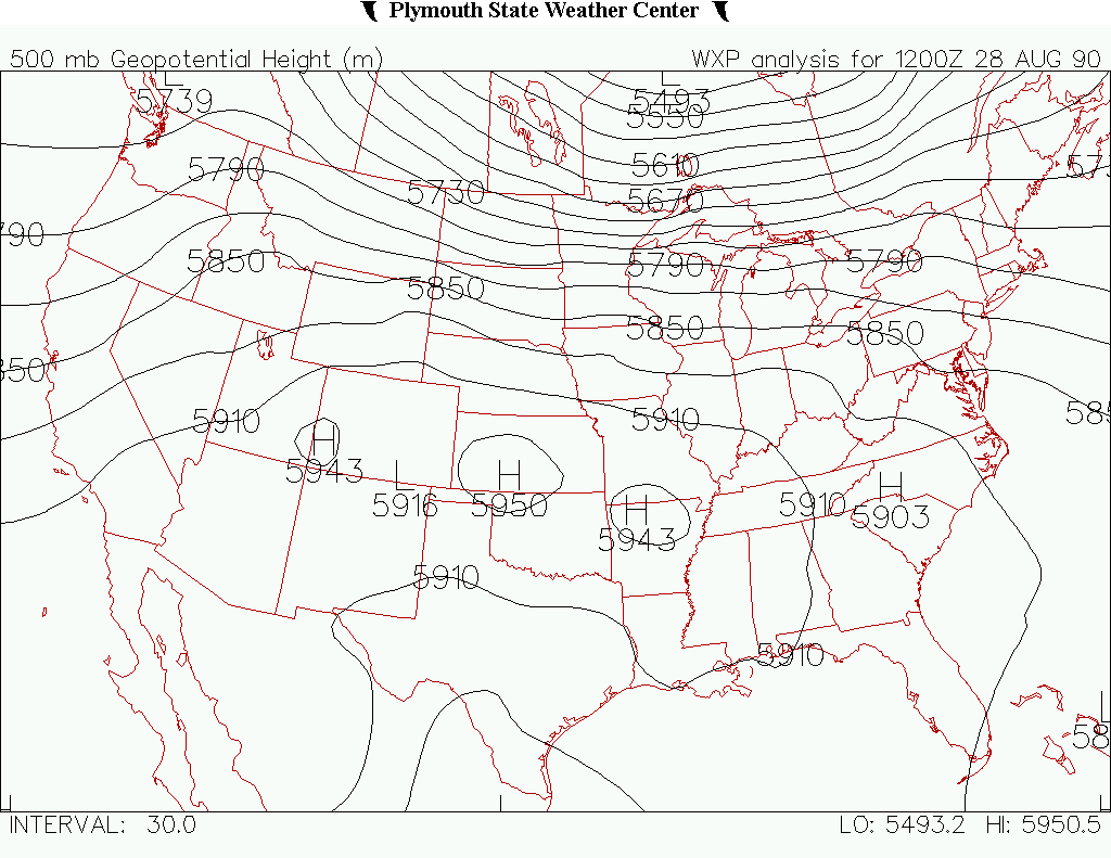
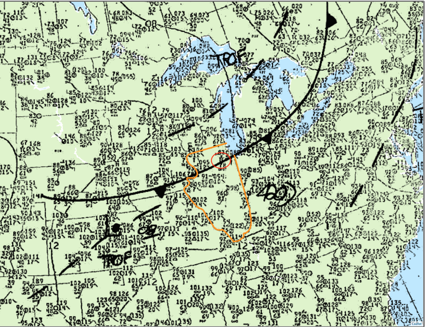
According to the NWS Chicago, IL (2015), the atmospheric conditions that led to this F5 tornado were typical of those leading to most severe weather cases. An upper level shortwave trough (Figure 1) was moving through the Great Lakes, while a cold front was pushing through the area (Figure 2)
According to the NWS Chicago, IL (2015), the National Severe Storms Forecast Center (NSSFC) in Kansas City, MO upgraded their thunderstorm outlook from SLIGHT to MODERATE risk of damaging storms. At 1:28 pm CDT, the NSSFC issued a severe thunderstorm watch for portions of northern Illinois.
Thunderstorms began initiating around noon near the central Illinois and Wisconsin border. Around the same time, it became obvious that conditions across northern Illinois were favoring supercell storms. By 3:00 pm CDT, instability values had risen to an incredible 7000 J/kg (Figure 3). The cold front could be observed crossing the state line at the same time.
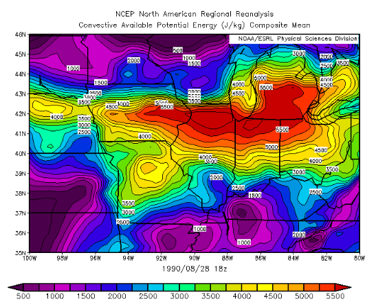
Temperatures ahead of the cold front were in the mid to upper 90s (F) with dew points in the upper 70s (F). According to the NWS Chicago, IL (2015), even with the lack of low-level shear, the impressive parameters for supercell growth along the cold front allowed a storm to produce tornadoes west of Rockford at 1:42 pm CDT. Eventually, a dominant storm emerged and ventured into the extreme instability axis (Figure 3) and strong shear, where it exploded to a height of 65 000 feet.
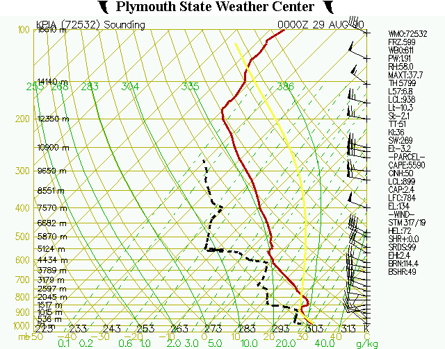
Figure 4 depicts the vertical profile of the atmosphere in Peoria, IL, which is roughly 100 miles from Plainfield, IL. The sounding shows large instability values and 50-60 kt winds at the mid-levels of the atmosphere, which contributed to favorable conditions for supercells (NWS Chicago, IL, 2015).
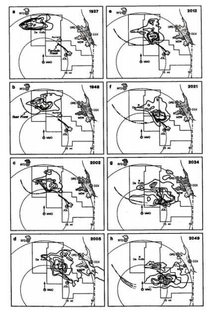
The tornado reached its maximum strength (F5) from 3:15 pm to 3:45 pm CDT ([e] through [h] in Figure 5) as it moved through Plainfield and Crest Hill. The tornado dissipated in Joliet after the parent supercell produced damage and fatalities across northern Illinois for four and a half hours.
Aftermath
The following paragraphs are taken from the National Climatic Data Center (1990) storm data publication. Some wording may be graphical in nature.
The Plainfield high school was destroyed. Six fatalities were observed in Plainfield as well as 55 homes destroyed and 205 damaged. Southeast of Plainfield, the Grand Prairie Elementary School and District Administrative Center were destroyed. At Saint Mary Immaculate, three fatalities occurred and significant damage was done to the church, school rectory and convent.
As the tornado continued southeast, several shopping malls were damaged. At Peerless Estates, 75 homes were destroyed and 148 damaged. At Lily Cache, one fatality was observed, 55 homes destroyed and 127 damaged. At Crystal Lawns, two fatalities were observed, 69 homes were destroyed and 324 damaged. At Warwick Estates, the tornado was at F3 to F2 intensity, where it killed two people, destroyed 50 homes and damaged 31.
At Crest Hill Lakes, the tornado killed eight people, some of which were thrown into fields from their apartments, and destroyed three buildings. At Colony West, 12 homes were destroyed. The tornado continued southeast into west Joliet with F2 to F1 strength, where three homes were destroyed and 88 damaged. The tornado weakened as it crossed Larkin Avenue just north of Glenwood Avenues and lifted within a half mile.

Recap
According to the NWS Chicago, IL (2015), “between 3:15 p.m. and 3:45 p.m. CDT on August 28th, 1990, a violent F5 tornado ripped through Kendall and Will counties taking the lives of 29 people and injuring 350. The tornado left a 16.4 mile-long damage path which ranged from 600 yards to a half a mile in width”. More than $250 million dollars in property damage occurred because of the F5 tornado (NOAA, 2019), with a total of 470 homes destroyed and 1000 damaged.
Sources
NWS Chicago, IL. (2015). 25 Years Later: The August 28th, 1990 Plainfield Tornado. Retrieved from: https://www.weather.gov/lot/Plainfield_Tornado_Anniversary
National Climatic Data Center. (1990). Storm data and unusual weather phenomena with late reports and corrections (Department of Commerce Publication No. 8, Vol 32). Asheville, NC. Retrieved from: https://www1.ncdc.noaa.gov/pub/data/swdi/stormevents/pub-pdf/storm_1990_08.pdf
Plymouth State University. (2019). Plymouth State Weather Center. Retrieved from: https://vortex.plymouth.edu/myo/upa/ctrmap-a.html
NWS Weather Prediction Center. (2017). Surface analysis 21Z Tue Aug 28 1990. Retrieved from: https://www.wpc.ncep.noaa.gov/archives/web_pages/sfc/sfc_archive.php
The Herald News. (2015). Plainfield 1990 tornado was unique in its formation, destruction, rebuilding. Retrieved from: https://www.theherald-news.com/2015/08/21/plainfield-1990-tornado-was-unique-in-its-formation-destruction-rebuilding/a3gw9ar/
NOAA’s National Centers for Environmental Information. (2019). Storm Events Database. Retrieved from: https://www.ncdc.noaa.gov/stormevents/listevents.jsp?eventType=%28C%29+Tornado&beginDate_mm=08&beginDate_dd=28&beginDate_yyyy=1990&endDate_mm=08&endDate_dd=28&endDate_yyyy=1990&county=ALL&hailfilter=0.00&tornfilter=0&windfilter=000&sort=DT&submitbutton=Search&statefips=17%2CILLINOIS