

The Forecast
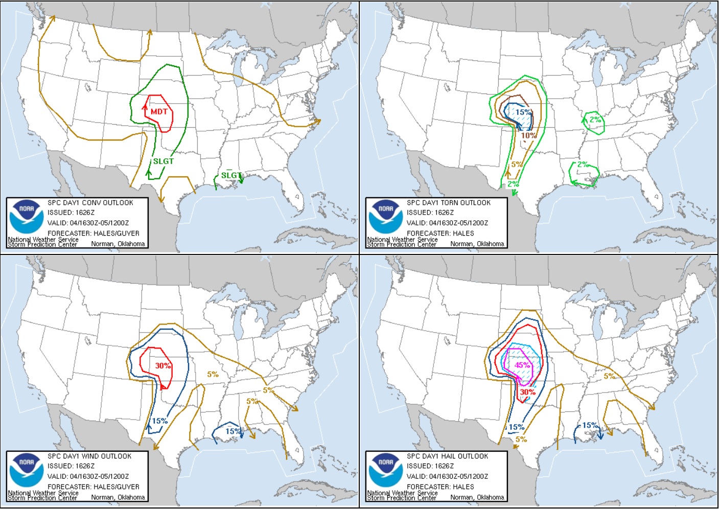
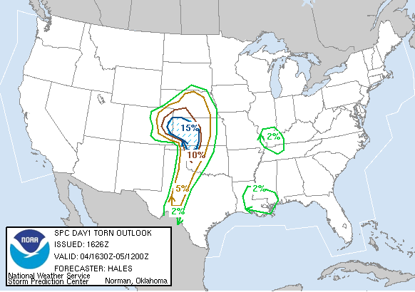
Figure 1 depicts the Storm Prediction Center’s (SPC) day 1 convective outlook, showing a moderate risk of severe thunderstorms with a 15% hatched probability of tornadoes on May 4, 2007. Figure 2 depicts a close-up of the tornado probability at 1630Z. In Figure 2, we see a a 15% hatched probability from southwestern Kansas into extreme eastern Colorado.
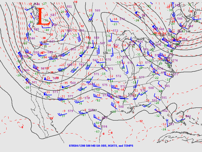
The synoptic pattern on the morning of May 4th was typical of spring in the southern Plains of the United States. Figure 3 depicts an upper-level trough ejecting in the Pacific Northwest. According to the SPC (2007) at 1651Z:
“A POWERFUL UPPER TROUGH IS DEVELOPING OVER THE INTERIOR PORTIONS OF THE WESTERN U.S. THIS SYSTEM IS FORECAST TO MOVE EASTWARD AND BEGIN AFFECTING THE CENTRAL AND NORTHERN PLAINS BY THIS AFTERNOON AND EVENING. STRONG WESTERLY WINDS ALOFT WILL SPREAD ACROSS THE SOUTHERN ROCKIES TODAY…WHILE A SURFACE LOW DEEPENS VICINITY OF THE SOUTHEAST COLORADO/SOUTHWESTERN KANSAS AREA. INCREASINGLY STRONG AND GUSTY SOUTHERLY LOW LEVEL WINDS ACROSS THE HIGH PLAINS WILL TRANSPORT RICH GULF MOISTURE NORTHWARD…WITH DEWPOINTS IN THE MID TO UPPER 60S EXPECTED AS FAR NORTH AS WESTERN KANSAS. STRONG DAYTIME HEATING AND RATHER COOL TEMPERATURES ALOFT WILL RESULT IN AN EXTREMELY UNSTABLE AIR MASS FROM PARTS OF NEBRASKA INTO WESTERN OKLAHOMA AND THE EASTERN TEXAS PANHANDLE. THUNDERSTORMS ARE EXPECTED TO DEVELOP OVER EASTERN COLORADO AND WESTERN KANSAS BY LATE AFTERNOON…SPREADING NORTHEASTWARD INTO PARTS OF NEBRASKA DURING THE EVENING”.
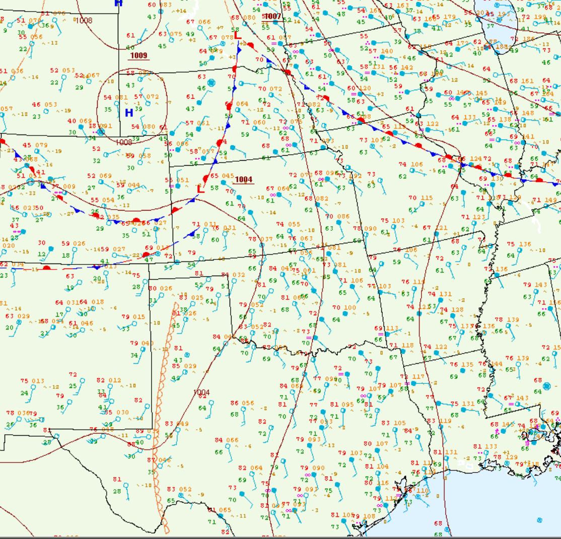
The situation at the surface was also typical of the southern Plains in spring. A dryline was seen advancing east-northeastward throughout the day. Figure 4 depicts the dryline at 1:00 pm CDT on May 4th in the Texas panhandle and western Texas.
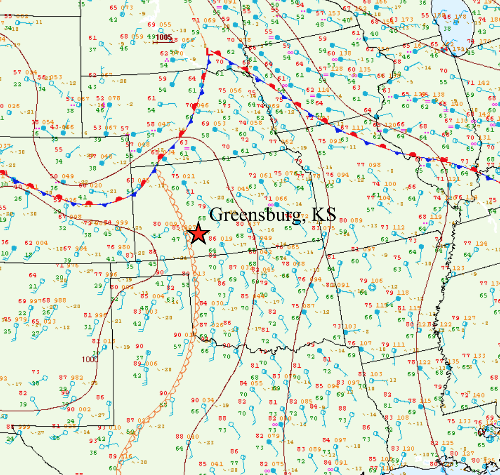
By 4:00 pm CDT, the dryline was extending into southwestern Kansas and sitting just west of Greensburg, KS (Figure 5).
Below are vertical profiles of the atmospheric conditions at Dodge City, KS, which is roughly 45 minutes west of Greensburg. The sounding on the left (12Z), shows that the atmosphere had a substantial “lid” or “cap” at 850mb with southerly winds at the surface. The sounding on the right at 7:00 pm CDT (00Z) shows a completely different story with an uncapped atmosphere around Greensburg.
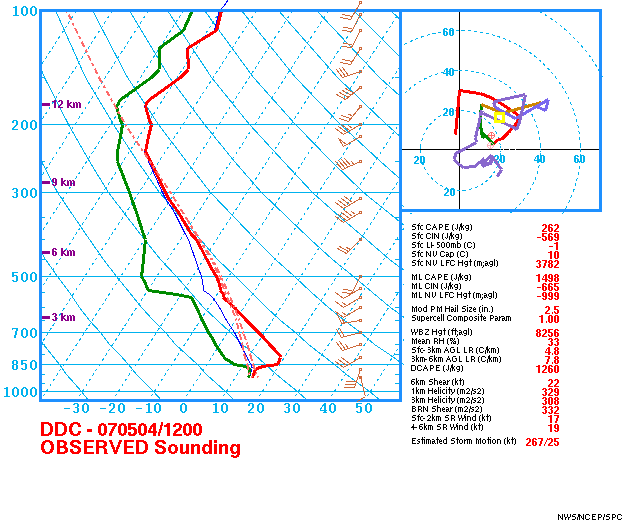
12Z Sounding at Dodge City, KS 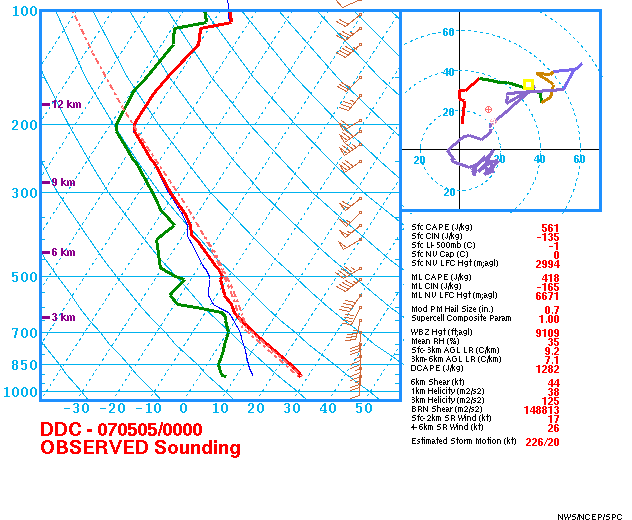
00Z Sounding at Dodge City, KS
The Tornado
At 2:53 pm CDT, the SPC issued a mesoscale discussion reading:
“TRENDS ARE BEING CLOSELY MONITORED FOR SIGNS OF CONVECTIVE INITIATION. ALTHOUGH TIMING IS STILL A BIT UNCERTAIN…ONE OR MORE TORNADO WATCHES WILL PROBABLY BE REQUIRED LATE THIS AFTERNOON”.
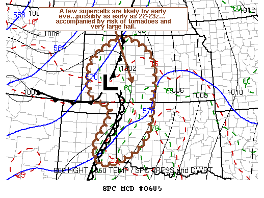
At the time of this mesoscale discussion, the SPC (2007) mentioned that the mixed-layer convective available potential energy (MLCAPE) was in the 3000-4000 J/kg range, which indicates a very unstable air mass.
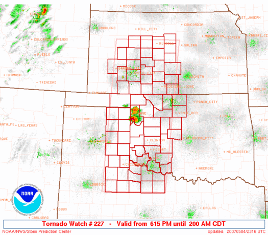
At 6:15 pm CDT, the SPC in Norman, OK issued tornado watch 227 for western and central Kansas, western and northern Oklahoma and the eastern Texas panhandle and northwest Texas (Figure7). The tornado watch read:
“WIDELY SCATTERED STORMS/SUPERCELLS POSSIBLE IN VERY UNSTABLE AIR MASS ALONG SLOWLY RETREATING DRY LINE THIS EVENING. STRENGTHENING ASCENT/WIND FIELD ASSOCIATED WITH APPROACHING FOUR CORNERS UPPER TROUGH MAY ENHANCE TORNADO POTENTIAL AFTER DARK AS LLJ INCREASES TO AROUND 50 KTS” (SPC, 2007).
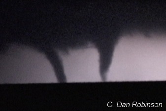
According to Bluestein (2009), left-splitting cells were the dominant mode of convection for the day until around 0030-0100 UTC (7:30 pm – 8:00 pm CDT), after which cell splitting was no longer observed. It took about one hour for the Greensburg storm to become tornadic and at 0127 UTC (8:27 pm CDT), a weak cyclonic signature was observed on Doppler radar, which can be associated with the first tornado observed on this storm. Figure 8 depicts all the associated tornadoes generated by this supercell storm.
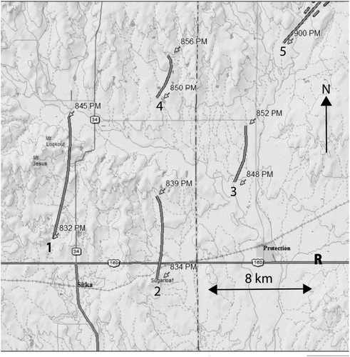
After a 30 minute interval of cyclic tornado production (Figure 8), the Greensburg EF5 tornado formed at 9:03 pm CDT (NOAA’s NCEI, 2019) and struck Greensburg roughly 50 minutes later (Bluestein, 2009). Below is a Doppler radar loop of the supercell that produced the Greensburg EF5 tornado.
Scientific Breakthrough from “Greensburg Storm”

According to Tanamachi, Bluestein, Houser, Frasier and Hardwick (2012), data were collected in the “Greensburg storm” by the University of Massachusetts X-band, mobile, polarimetric Doppler radar for an astounding 70 minutes, where 10 tornadoes were detected. This mobile Doppler radar data set is one of only a few documenting an EF5 tornado and the supercell’s transition from short-track, cyclic tornado production to long-track tornado production.
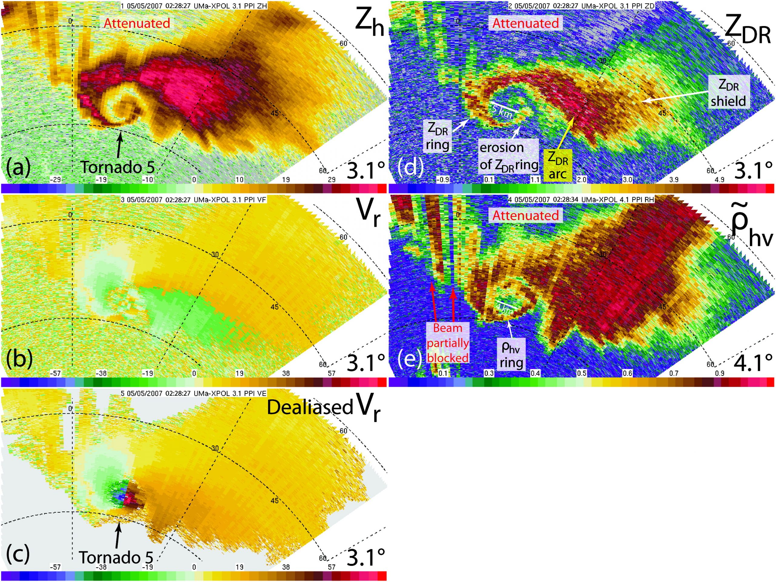
According to Tanamachi et al. (2012), the structure of the Greensburg supercell’s hook changed considerably throughout the UMass X-Pol deployment. Figure 11 depicts the evolution of the “hook echo” of the Greensburg storm.
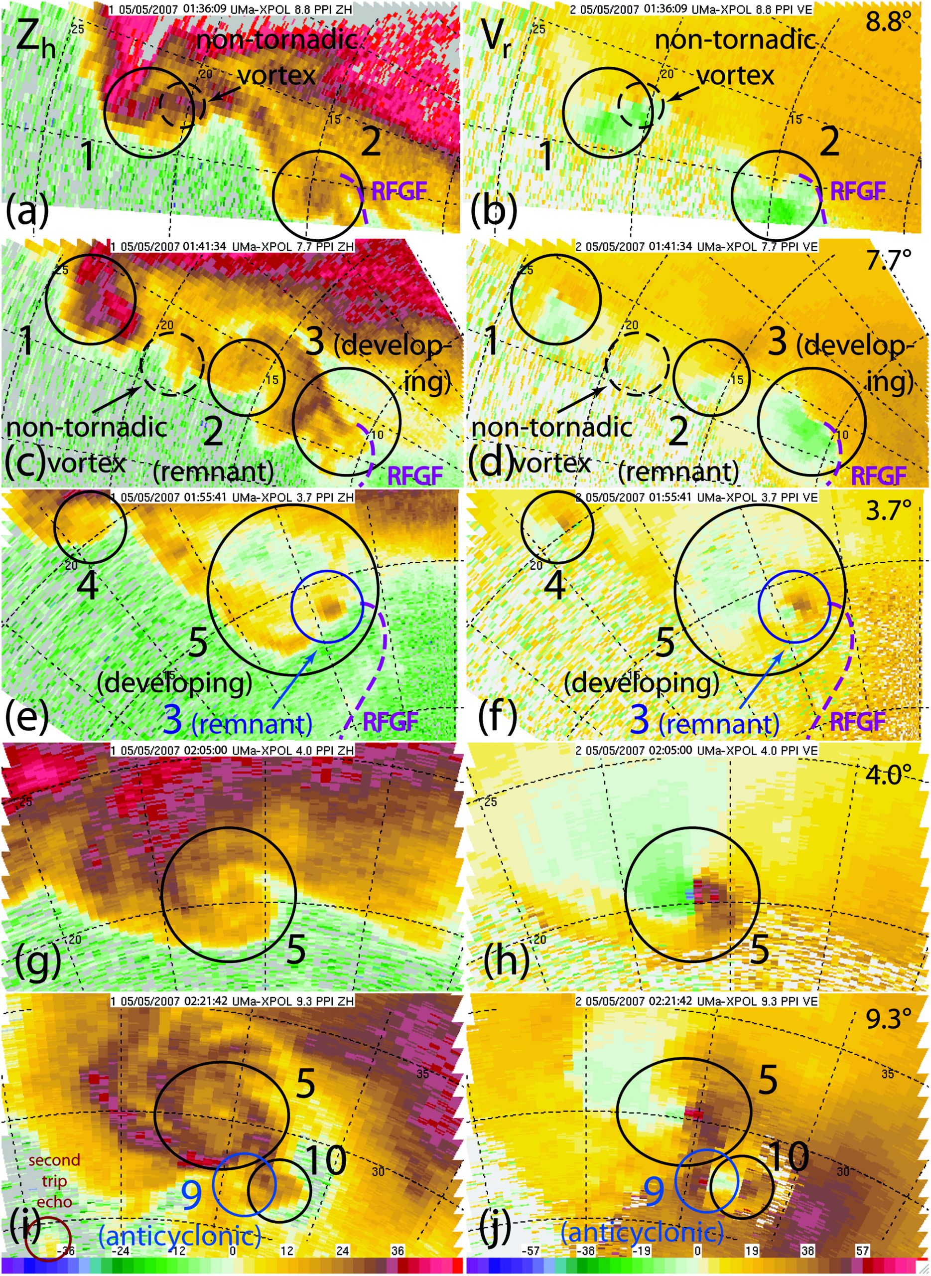
At 0139 UTC (8:39 pm CDT), a maximum of four simultaneous radar velocity signatures were detected by the UMass X-Pol (Figure 11. c,d), representing several different tornadoes at varying stages of their life-cycle (Tanamachi et al., 2012).
Recap
According to Bluestein (2009), during the evening of May 4, 2007, the “Greensburg Storm” cyclically produced tornadoes for about 30 minutes before producing a large, long-lived tornado. According to NOAA’s NCEI’s storm event database (2019), an EF0 tornado developed at 8:48 pm CDT four miles north-northwest of Protection, KS in Comanche County. The tornado travelled northeastward for 2.9 miles with a maximum width of 50 yards. The tornado caused no fatalities, injuries or property damage and ended at 8:52 pm CDT six miles north of Protection, KS in Comanche County.
Sources
NOAA’s National Centers for Environmental Information. (2019). Storm Events Database. Retrieved from: https://www.ncdc.noaa.gov/stormevents/eventdetails.jsp?id=35937
NOAA’s National Weather Service Storm Prediction Center. (2007). Severe Weather Event: May 04, 2007. Retrieved from: https://www.spc.noaa.gov/exper/archive/event.php?date=20070504
NOAA’s National Weather Service Storm Prediction Center. (2019). Surface and Upper Air Maps. Retrieved from: https://www.spc.noaa.gov/obswx/maps/
NWS Weather Prediction Center. (2017). WPC’s Surface Analysis Archive. Retrieved from: https://www.wpc.ncep.noaa.gov/archives/web_pages/sfc/sfc_archive.php
National Weather Service Dodge City, Kansas. (2012). Greensburg – Five years after EF-5 tornado. Retrieved from: https://www.weather.gov/ddc/greensburgfiveyear
NOAA’s Storm Prediciton Center. (2019). U.S. Tornado Outbreak Interface. Retrieved from: https://www.spc.noaa.gov/exper/outbreaks/#
Tanamachi, R.L., H.B. Bluestein, J.B. Houser, S.J. Frasier, and K.M. Hardwick, 2012: Mobile, X-band, Polarimetric Doppler Radar Observations of the 4 May 2007 Greensburg, Kansas, Tornadic Supercell.Mon. Wea. Rev.,140, 2103–2125, https://doi.org/10.1175/MWR-D-11-00142.1
Bluestein, H.B., 2009: The Formation and Early Evolution of the Greensburg, Kansas, Tornadic Supercell on 4 May 2007.Wea. Forecasting,24, 899–920, https://doi.org/10.1175/2009WAF2222206.1
National Weather Service Dodge City, Kansas. (2008). The Rebuilding of Greensburg – one year later [PDF]. Retrieved from: https://www.weather.gov/media/ddc/Greensburg_1year_later.pdf
Stormtrack. (n.d.). May 4, 2007: Greensburg, Kansas and Arnett, Oklahoma tornadoes. Retrieved from: https://stormtrack.org/weather-library/storm-chasing-event-archive/2007-events/may-4-2007-greensburg-kansas-and-arnett-oklahoma-tornadoes/