In the early afternoon hours of June 28th, an intense tornado-warned supercell developed near Brandon and move north-northeast towards Rapid City in Manitoba. This storm intensified into a high-precipitation supercell and dropped a long-track EF2 tornado southeast of Rapid City.
A tornado warning was issued by Environment Canada as intense rotation was detected on radar:
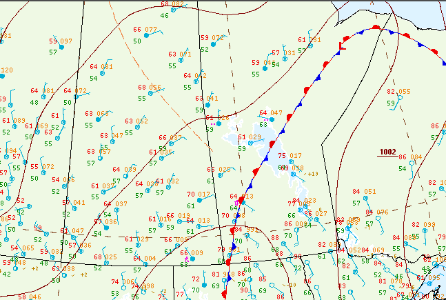
Figure 1 depicts the surface observations at 1:00 pm CDT, which shows a stationary front across western Manitoba. This front became the focus for intense thunderstorms in the afternoon and evening hours of June 28th, which ultimately led to this tornado.

According to Environment and Climate Change Canada (2018), an EF2 tornado touched down at 3:45 pm CDT 5 km southeast of Rapid City, MB. The tornado travelled for 5.6 km with a maximum width of 200 metres. The tornado caused no fatalities or injuries and the property damage assessment is still ongoing.
Weather summary
for Manitoba
issued by Environment Canada
at 4:43 p.m. CDT Tuesday 30 June 2020.

Discussion.

Tornado touchdown near Rapid City, MB on June 28, 2020 confirmed.

On the afternoon of June 28, 2020, a severe thunderstorm moved through southwestern Manitoba. Environment Canada received reports of golf ball sized hail, rainfall in excess of 150 mm, and a tornado near Rapid City.

Storm assessment, conducted in partnership with the Northern
Tornadoes Project (NTP) out of Western University and the University
of Manitoba:

Time: 3:45 pm CDT
Location: 5 km southeast of Rapid City
Damage: Two large drive sheds destroyed, hundreds of trees snapped and uprooted, two barns with significant damage, trailers flipped, grain bins toppled
Rating: Low-end EF-2
Estimated maximum wind speed: 190 km/h
Path length: 5.6 km
Maximum path width: 200 m
No injuries or fatalities

There was a small area of downburst damage as well to the northwest of the tornado track, where there were a number of grain silos toppled.

Environment Canada meteorologists are actively seeking pictures of the tornado or damage it may have caused. Should you have any information regarding this event, or to report severe weather at any time, please call 1-800-239-0484, send an email to ec.storm.ec(at)canada.ca, or tweet to (hash)mbstorm. Note that these storm assessments are considered preliminary and may be changed if more information becomes available.

Please note that this summary may contain preliminary or unofficial information and does not constitute a complete or final report.

End/PASPC
Sources
NWS Weather Prediction Center Surface Analysis Archive. (2017). Surface analysis 18Z Sun Jun 28 2020. Retrieved from: https://www.wpc.ncep.noaa.gov/archives/web_pages/sfc/sfc_archive.php
Environment and Climate Change Canada Data. (2018). Canadian National Tornado Database: Verified Events (1980-2009) – Public. Retrieved from: http://donnees.ec.gc.ca/data/weather/products/canadian-national-tornado-database-verified-events-1980-2009-public/

