

Touching down at 2:35 am, this probable tornado developed at the south end of the lake and struck the Balsam Lake Trailer Park. Trailer homes were flipped over and thrown, one of which was reportedly tossed more than 250m. Five trailers were torn apart and demolished with only a a few walls remaining. Two cars were also destroyed, one of them crushed by a trailer that was blown onto it, and another picked up, flipped onto its side and smashed into the base of an overturned trailer. Throughout the park, trees and power poles were snapped and the debris of destroyed trailer homes blanketed the area. Damage here approached F2 intensity, and ten people from the park were sent to hospital to be treated for minor injuries.
It tracked through fields for about 2km to the east of the trailer park, then struck a farm on Omega Road where it tore the roof off of a barn and scattered debris. It likely dissipated shortly thereafter, however, a second narrow and concentrated area of damage was occurring about 3km to the north at the cottage community of Long Point. Although damage there is officially classified as being the result of straight line winds, it is the author’s opinion that this too may have been the result of a separate tornado.
Located on a large peninsula emerging from the south end of the lake, Long Point experienced devastating damage that was particularly concentrated in a 200m wide swath at the north end of the point. There, at a cottage that was owned by the Williamson family, almost all trees on the property – dozens of them – were snapped and in some case thrown. Windows were blown in, antennas twisted, furniture thrown and the cottage crushed by falling trees. The family survived the tornado huddled in the kitchen of their ruined cottage, emerging with only minor injuries. Their cottage and another across the road were splattered in mud and cached with the leaves of shredded trees.
This was one of four tornadoes that touched down in Cottage Country as a violent derecho swept across Central Ontario. The others:
- F1 at Kennisis Lake
- F0 at Clearwater Beach
- F2 at Bridgenorth
The Forecast
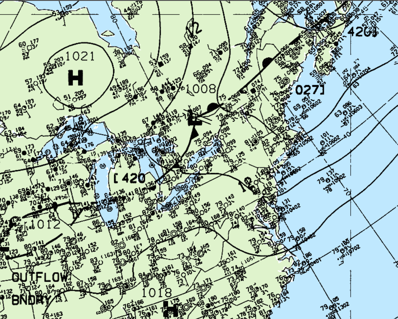
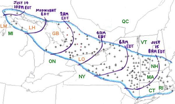
Figure 2 depicts the surface observations on the early morning hours of July 15, 1995. According to the Storm Prediction Center (2018), a bow echo was ongoing since July 14th across the Great Lakes region (Figure 1). At the time of Figure 2, storms were located along the cold front in southern Ontario, extending from the low pressure system. This derecho can be seen via the radar loop shown below. Radar imagery loop from Environment Canada’s King City, Ontario radar (Storm Prediction Center, 2018). Radar imagery loop from Environment Canada’s King City, Ontario radar (Storm Prediction Center, 2018).
“As the bow echo system producing the derecho crossed northern Lake Huron (LH) and Georgian Bay (GB), it grew in scale and severe winds affected a large part of southern Ontario (ON) during the pre-dawn hours of Saturday, July 15th (Figure ##). Some damage occurred in the Toronto metropolitan area near the southern edge of the derecho, and a wind gust to 136 kph (85 mph) was measured at the Buttonville Airport just north of the city. However, the most severe damage, which likely was associated with wind gusts up to 160 kph (100 mph) or more, occurred along a band from the “Cottage Country” east of Georgian Bay to the northeastern corner of Lake Ontario (LO) and adjacent parts of the St. Lawrence River Valley. This swath of damage was associated with the most rapidly moving part of the bowed line, as depicted in the above radar imagery loop from Environment Canada’s King City, Ontario radar. While most of the damage was associated with intense straight-winds, several brief tornadoes occurred in the bowed line. Most were weak, but a strong F2 intensity tornado hit the town of Bridgenorth, destroying a marina and damaging 20 homes” (Storm Prediction Center, 2018).
Recap
According to Environment and Climate Change Canada (2018), an F1 tornado touched down at 2:35 am EDT near Balsam Lake, ON. The track and width of the tornado was not documented by ECCC. The tornado caused no fatalities or injuries, but caused $750 thousand dollars in property damage.
Sources
Storm Prediction Center. (2018). July 12-13, 1995 Derecho “The Right Turn Derecho”. Retrieved from: https://www.spc.noaa.gov/misc/AbtDerechos/casepages/jul1995derechopage.htm
NWS Weather Prediction Center. (2017). Surface analysis 06Z Sat Jul 15 1995. Retrieved from: https://www.wpc.ncep.noaa.gov/archives/web_pages/sfc/sfc_archive.php
Environment
and Climate Change Canada Data. (2018). Canadian National Tornado
Database: Verified Events (1980-2009) – Public. Retrieved from: http://donnees.ec.gc.ca/data/weather/products/canadian-national-tornado-database-verified-events-1980-2009-public/