

An F1 tornado developed southeast of Pecatonica in Illinois on the early evening of August 28, 1990. This tornado was part of the same cold front, which sliced through northern Illinois and eventually dropped the Plainfield, IL F5 tornado later in the afternoon.
The Forecast
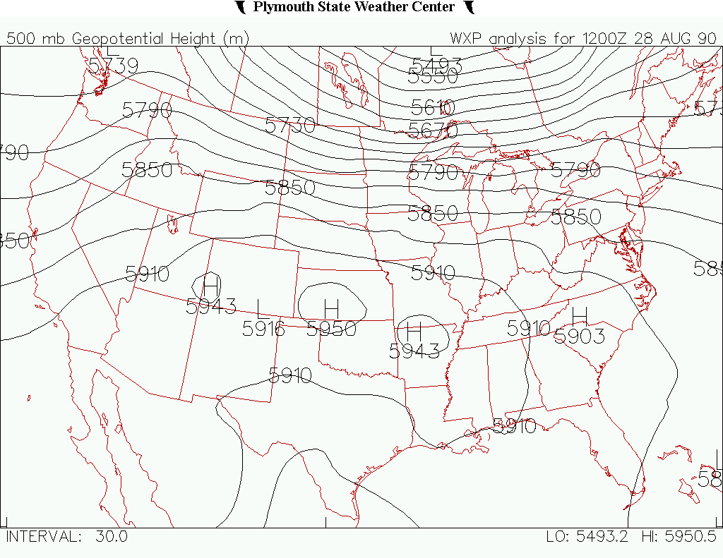
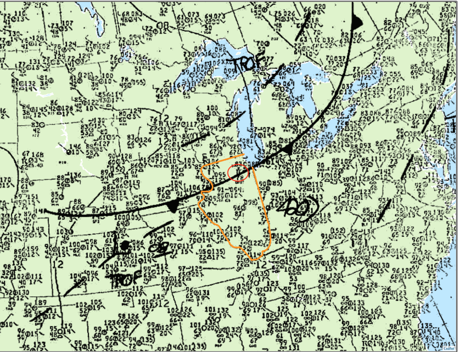
According to the NWS Chicago, IL (2015), the atmospheric conditions that led to this tornado were typical of those leading to most severe weather cases. An upper level shortwave trough (Figure 1) was moving through the Great Lakes, while a cold front was pushing through the area (Figure 2).
According to the NWS Chicago, IL (2015), the National Severe Storms Forecast Center (NSSFC) in Kansas City, MO upgraded their thunderstorm outlook from SLIGHT to MODERATE risk of damaging storms. At 1:28 pm CDT, the NSSFC issued a severe thunderstorm watch for portions of northern Illinois.
Thunderstorms began initiating around noon near the central Illinois and Wisconsin border. Around the same time, it became obvious that conditions across northern Illinois were favoring supercell storms. By 3:00 pm CDT, instability values had risen to an incredible 7000 J/kg (Figure 3). The cold front could be observed crossing the state line at the same time.
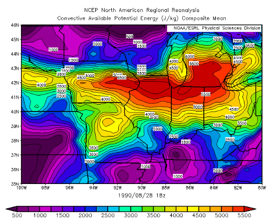
Temperatures ahead of the cold front were in the mid to upper 90s (F) with dew points in the upper 70s (F). According to the NWS Chicago, IL (2015), even with the lack of low-level shear, the impressive parameters for supercell growth along the cold front allowed a storm to produce tornadoes west of Rockford at 1:42 pm CDT. Eventually, a dominant storm emerged and ventured into the extreme instability axis (Figure 3) and strong shear, where it exploded to a height of 65 000 feet.
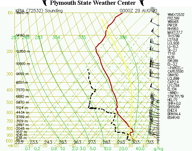
Figure 4 depicts the vertical profile of the atmosphere in Peoria, IL, which is roughly 100 miles from Plainfield, IL. The sounding shows large instability values and 50-60 kt winds at the mid-levels of the atmosphere, which contributed to favorable conditions for supercells (NWS Chicago, IL, 2015).
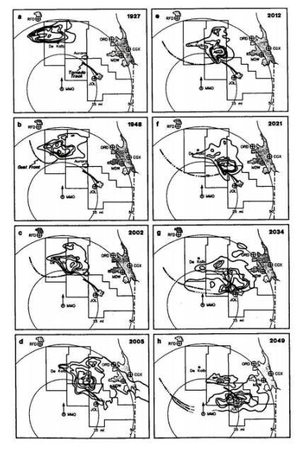
The tornado reached its maximum strength (F5) from 3:15 pm to 3:45 pm CDT ([e] through [h] in Figure 5) as it moved through Plainfield and Crest Hill. The tornado dissipated in Joliet after the parent supercell produced damage and fatalities across northern Illinois for four and a half hours.
Recap
According to the NOAA’s Storm Event Database (2019), an F1 tornado developed just southeast of Pecatonica, IL in Winnebago County at 1:42 pm CDT. The tornado travelled due south for three miles and had a maximum width of 103 yards to end north of Seward, IL. The tornado caused no fatalities or injuries but caused $25 thousand dollars in property damage. The storm responsible for this tornado would later re-intensify and develop an F5 tornado in Plainfield, IL.
Sources
NWS Chicago, IL. (2015). 25 Years Later: The August 28th, 1990 Plainfield Tornado. Retrieved from: https://www.weather.gov/lot/Plainfield_Tornado_Anniversary
Plymouth State University. (2019). Plymouth State Weather Center. Retrieved from: https://vortex.plymouth.edu/myo/upa/ctrmap-a.html
NWS Weather Prediction Center. (2017). Surface analysis 21Z Tue Aug 28 1990. Retrieved from: https://www.wpc.ncep.noaa.gov/archives/web_pages/sfc/sfc_archive.php
NOAA’s National Centers for Environmental Information. (2019). Storm Events Database. Retrieved from: https://www.ncdc.noaa.gov/stormevents/listevents.jsp?eventType=%28C%29+Tornado&beginDate_mm=08&beginDate_dd=28&beginDate_yyyy=1990&endDate_mm=08&endDate_dd=28&endDate_yyyy=1990&county=ALL&hailfilter=0.00&tornfilter=0&windfilter=000&sort=DT&submitbutton=Search&statefips=17%2CILLINOIS