

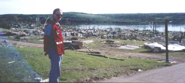
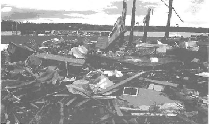
According to Bachmeier & Nelson II (2001), a tornado occurred in the vicinity of Pine Lake in Alberta on July 14, 2000 from 6:45 pm to 7:15 pm local time (MDT). Pine Lake is a community roughly 25 km southeast of Red Deer in south central Alberta. This tornado did F3 damage and killed 12 people, making it the deadliest tornado in Canada since the July 31, 1987 Edmonton, AB F4 tornado. The tornado moved through the Green Acres lakeside campground (Figure 1), killing 12, injuring 130 and dropping golf ball to baseball size hail in the process. The tornado caused $12 million dollars in property damage (ECCC, 2018). Skip to the “recap” section for quick statistics about this tornado.
The Forecast
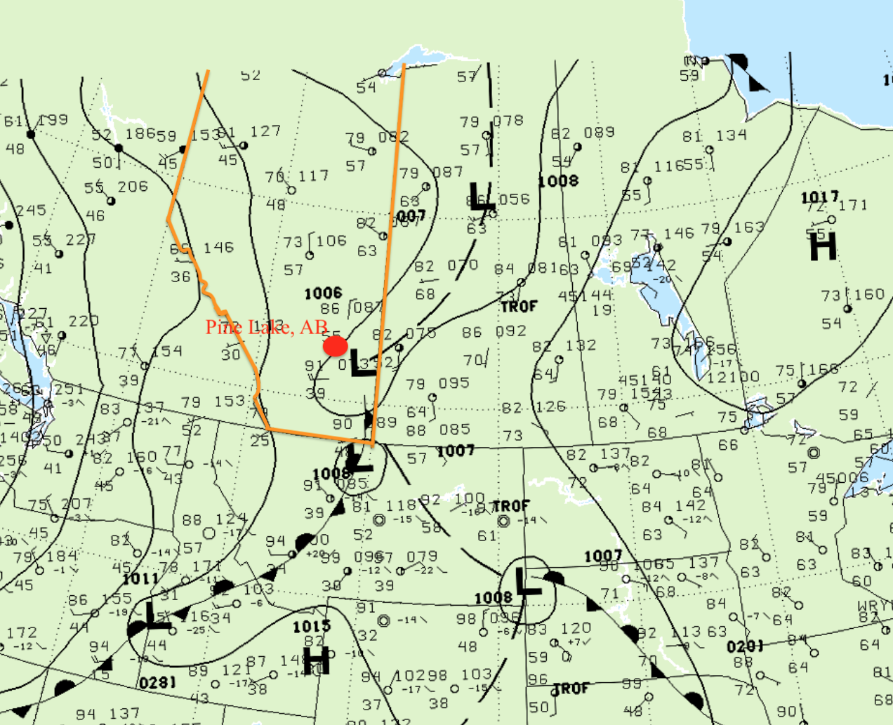
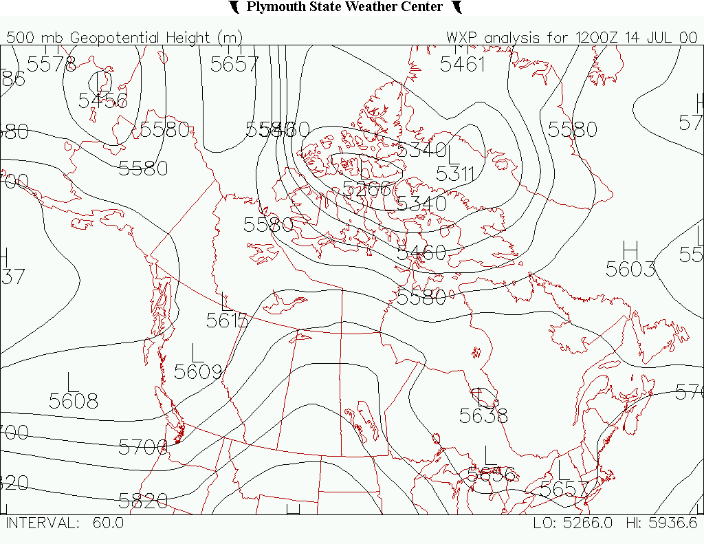
Bachmeier & Nelson II (2001) described the synoptic pattern as a shortwave trough moving eastward across British Columbia, thereby producing southwesterly flow across Alberta. A mid-upper jet streak was also enhancing shear in the area. Figure 3 depicts the upper-level trough and associated upper-level low pressures in British Columbia. The resulting high pressure (over Wyoming) or upper-level ridge brought southwesterly flow into Alberta.
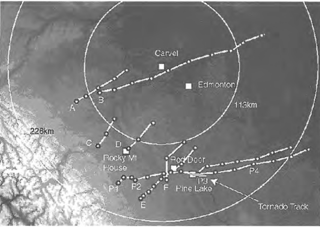
The Pine Lake storm originated from the foothills (Figure 5) shortly after 2000 UTC. According to Strong & Smith (2004), severe thunderstorms were forecast by the Weather Office for the region on this day. A storm watch was issued at 2330 UTC, which was later upgraded to a weather warning at 0018 UTC. “Surface observations showed evidence of a dryline across southwestern Alberta, but also suggested that a region of higher moisture existed east of the developing convection” (Bachmeier & Nelson II, 2001). 61 F (16.1 C) dew points were observed ahead of the Pine Lake storm, which further enhanced its development.
The Tornado
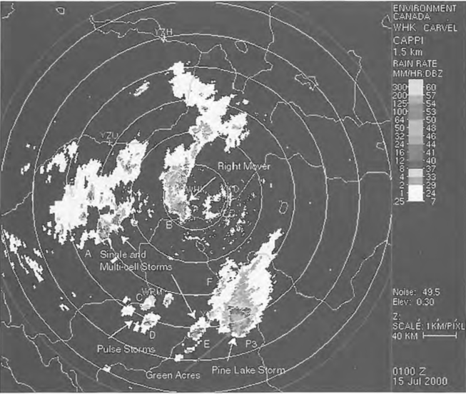
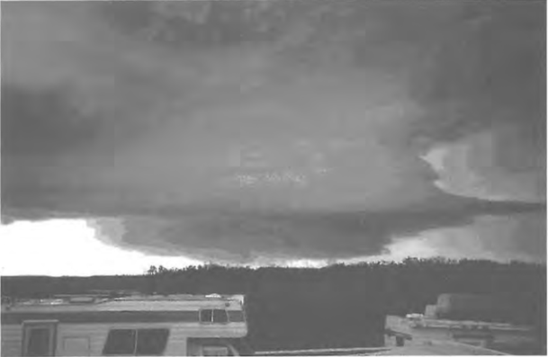
Joe & Dudley (2000) notes that the storm that dropped the Pine Lake tornado was a long track storm. Figure 4 depicts the radar imagery of the storm while it was dropping the tornado, but this storm began further west in the foothills (Figure 5).
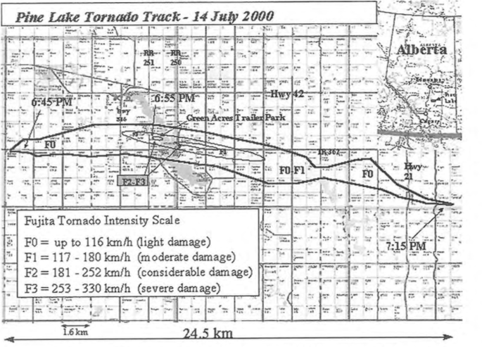
The tornado touched down 8.5 km west of Pine Lake at approximately 6:45 pm MDT and producing F0 damage. 3 km away from Pine Lake, the tornado intensified to F1 and the tornado grew to maximum intensity (F2-F3) as it crossed Range Road 251 and entered the Green Acres trailer park at 6:55 pm. Table 1 lists a timeline of the Pine Lake storm and the reported damage.
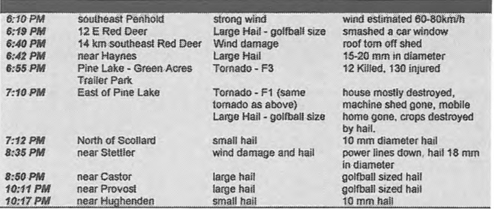
In the trailer park, the tornado cut a path of destruction 250 metres wide with wind speeds of 200-300 km/h, which threw cars and trucks up to 50 metres (Joe & Dudley, 2000).
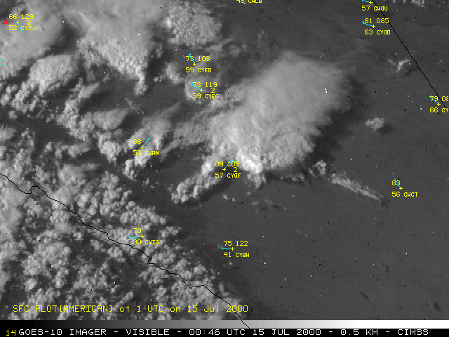
Figure 6 shows a satellite depiction of the storms in south-central Alberta on July 14, 2000. The Pine Lake storm is seen initiating on the foothills and moving east-northeast, before it “right-turns” east-southeast. Figure 7 below depicts radar screen grabs of the Pine Lake storm and its evolution.
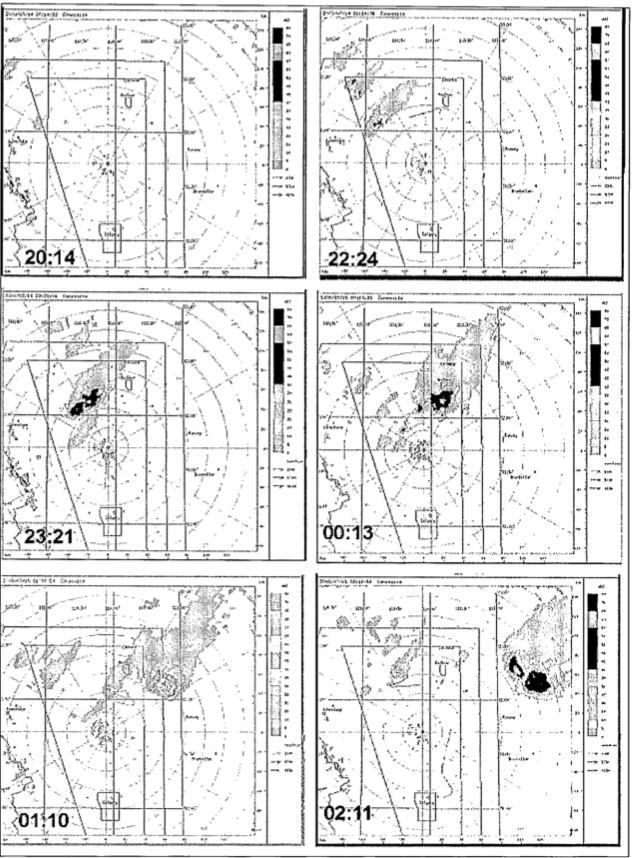
Figure 8 depicts the NOAA-12 polar orbiting satellite observation on July 14th, showing cloud tops and cloud top temperature structure. The NOAA-12 10.8 micrometer infrared indicated colder cloud temperatures within the “Enhanced-V” signature indicated in Figure 8 by a black arrow. According to Bachmeier & Nelson II (2001), the NOAA-12 polar orbiter revealed Enhanced-V top signature 20 mins before the Pine Lake storm produced large hail and 49 mins before producing the tornado.
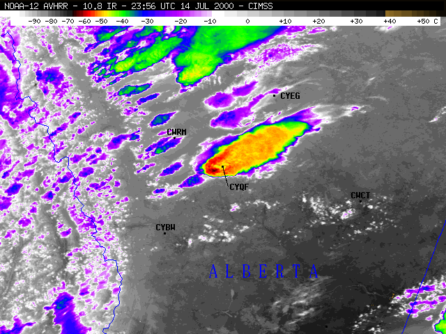
“Enhanced-V” top signatures, often referred to as “flying eagle” is a classic depiction of storm intensification and updraft intensification on infrared (IR) imagery. This feature gets its name from the shape it produces on IR imagery. The basis of this is updraft speeds increasing, usually indicating very large hail or possible tornadic activity.
Aftermath
According to Joe & Dudley (2000), damage to buildings, some totally destroyed, including well-constructed cottages, were left with only flooring and/or only one wall left standing. Clear F3 tornado damage was found on the eastern shores of Pine Lake, where one home was totally destroyed with only its floor remaining. The walls and roof of this home were not found (Joe & Dudley, 2000).
According to Joe & Dudley (2000), the tornado maintained moderate intensity for 5 km east of Pine Lake, where it began tracking southeast and weakening. The tornado weakened further for another 2.5 km where it dissipated east of Highway 21 at Township Road 360 around 7:15 pm MDT.
Recap
According to Joe & Dudley (2000), the Pine Lake, AB F3 tornado of July 14, 2000 traveled for 24.5 km, varied in width from 50 metres to 1600 metres (1.6 km) and was on the ground for 30 mins. According to ECCC (2018), the tornado caused $12 million dollars in property damage, caused 12 fatalities and 130 injuries. ECCC (2018) catalogues the tornado’s path as 27.3 km long and a maximum width of 1.6 km. According to Strong & Smith (2004), this was the deadliest tornado in North America in 2000.
According to Bachmeier & Nelson II, a west to east oriented axis of enhanced boundary layer moisture was evident across eastern Alberta (Figure 12). This feature was likely a key ingredient in the motion and intensification of the Pine Lake supercell (2001).
Sources
Bachmeier, A. S. & Nelson, J. P. (2001). A Satellite Perspective of the Pine Lake, Alberta Tornado Event [PDF]. Retrieved from: ftp://ftp.ssec.wisc.edu/visit/pine_lake_30.pdf
Environment and Climate Change Canada Data (2018). Canadian National Tornado Database: Verified Events (1980-2009) – Public. Retrieved from: http://donnees.ec.gc.ca/data/weather/products/canadian-national-tornado-database-verified-events-1980-2009-public/
Central Alberta Amateur Radio Club (2019). Archive of the Pine Lake Tornado July 14 2000. Retrieved from: http://www.caarc.ca/429-2
Weather Prediction Center’s Archive (2019). Surface analysis 00Z Sat Jul 15 2000. Retrieved from: https://www.wpc.ncep.noaa.gov/archives/web_pages/sfc/sfc_archive.php
Plymouth State University (2019). Plymouth State Weather Center. Retrieved from: https://vortex.plymouth.edu/myo/upa/ctrmap-a.html
Strong, G.S. & Smith, C. D. (2004). Assessment and Prediction of Prairie Severe Thunderstorm Weather Phenomena. Retrieved from: https://www.google.com/url?sa=t&rct=j&q=&esrc=s&source=web&cd=2&cad=rja&uact=8&ved=2ahUKEwiJqMutkYjkAhUQTt8KHXzJDe0QFjABegQIAhAC&url=https%3A%2F%2Fwww.publicsafety.gc.ca%2Flbrr%2Farchives%2Fqc%2520968%2520a88%25202001-eng.pdf&usg=AOvVaw2SiY1J-TFbH8nt67j0O_Je
Joe, P. & Dudley, D. (2000). A Quick Look at the Pine Lake Storm. CMOS Bulletin SCMO Vol.28 No.6. Retrieved from: https://www.google.com/url?sa=t&rct=j&q=&esrc=s&source=web&cd=1&cad=rja&uact=8&ved=2ahUKEwjg0ODVhojkAhXGnOAKHcYzA5kQFjAAegQIAhAC&url=http%3A%2F%2Fcmosarchives.ca%2FBulletin%2Fb2806.pdf&usg=AOvVaw3-4bvR15FzpQIfUxiAwMT0