

Published on
Theres not many hobbies that feature the level of frustration that storm chasing does. Just when you think you have something figured out, the weather goes ahead and surprises you in a manner you’d never expect. These kinds of frustrations tend to manifest themselves on varying timescales; your chase pattern itself might oscillate between good and bad in the days leading up. A particular day may look great in the morning before being a complete and total bust. In my experience, a particular chase day surprising you usually does so in a negative manner — you wake up to a moderate risk only to have the entire thing completely crap out. May 23rd, 2019 however was a chase day surprise like I’ve never experienced — and man was it a great surprise.
The pattern preceding May 23rd was absolutely loaded. We saw tornadoes three of the previous five days and most of those tornadoes were strong and photogenic. A chasers dream. Aside from the high risk on May 20th, May 23rd looked to be arguably the most potent setup within our week-long chasecation. While a slightly lower probability day, at least from a Storm Prediction Center perspective than even the previous day (10% hatched vs. 15% hatched for tornadoes on May 22nd), the setup was one that looked absolutely primed for significant tornadoes in the Texas Panhandle. Coming off a frustrating yet highly rewarding chase the night before, May 23rd was kind of all gravy to me. It was our last day on the plains but we’d had so much success already that there wasn’t much that I felt could make the trip much better. How wrong I would soon find out I was.
Now much like Nebraska, I’ve never had much luck in the Texas Panhandle. In fact, I flat out dislike chasing there. Everyone talks about “Caprock magic” but to me, its a poor road network, ranch land and the unchaseable Palo Duro Canyon. Couple this with the fact that we had to make a 12:30pm flight out of Kansas City the next day, I set my expectations fairly low. We woke up relatively early in Oklahoma City and started making our way west towards Amarillo, expecting early initiation along a sagging cold front in the northern Panhandle. We made it out to Amarillo around lunch time only to discover that the front had been convectively reenforced by thunderstorms to the northwest, pushing it further east than expected. This immediately rang some alarm bells, further lowering our expectations. After lunch, we pushed east to Conway, Texas where we sat at a Love’s gas station with what seemed like every other chaser on the planet. While at the Loves, I was fortunate enough to meet up with Kelton Halbert, Colin Davis, Andrew Pritchard, Alex Hall and Will Leverett, the latter four of whom I’d never met before. To me, the day was already looking up.
After a couple of hours at the Loves, storms began to develop along the front — but on the cold side of the boundary. Needless to say, this wasn’t a particularly good sign in terms of convective trend. Nevertheless, we decided to stay with a storm that had begun to take on some supercellular characteristics hoping that perhaps it would right-turn off the boundary and move into a rather pristine thermodynamic and kinematic environment just to the east. We watched for several hours as storms were just kind of there. They didn’t do an awful lot, seemingly oscillating between legitimate supercellular structures and large, pseudo-MCS blobs. Although the storms would several times become tornado warned, it became rather obvious they wouldn’t produce tornadoes in their current configuration. After two or so hours of doing the dance, we decided we’d let the first storm we’d been watching move off to the north and wait 20 or so minutes for the storm directly to its south to come at us. This storm had a slightly more eastward component to its motion, and we figured that the environment it was heading into was pretty spectacular. Although fairly unenthused about the potential, we patiently waited, figuring once this storm got to us we’d take a peak and head back towards the hotel.
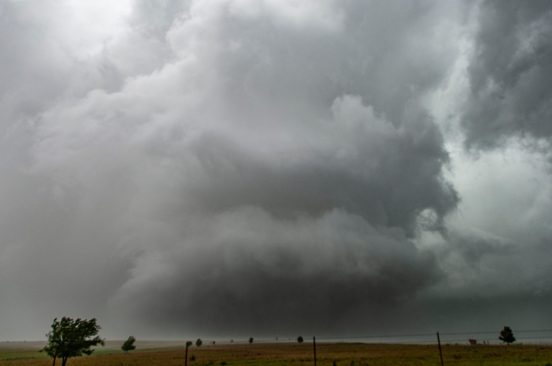
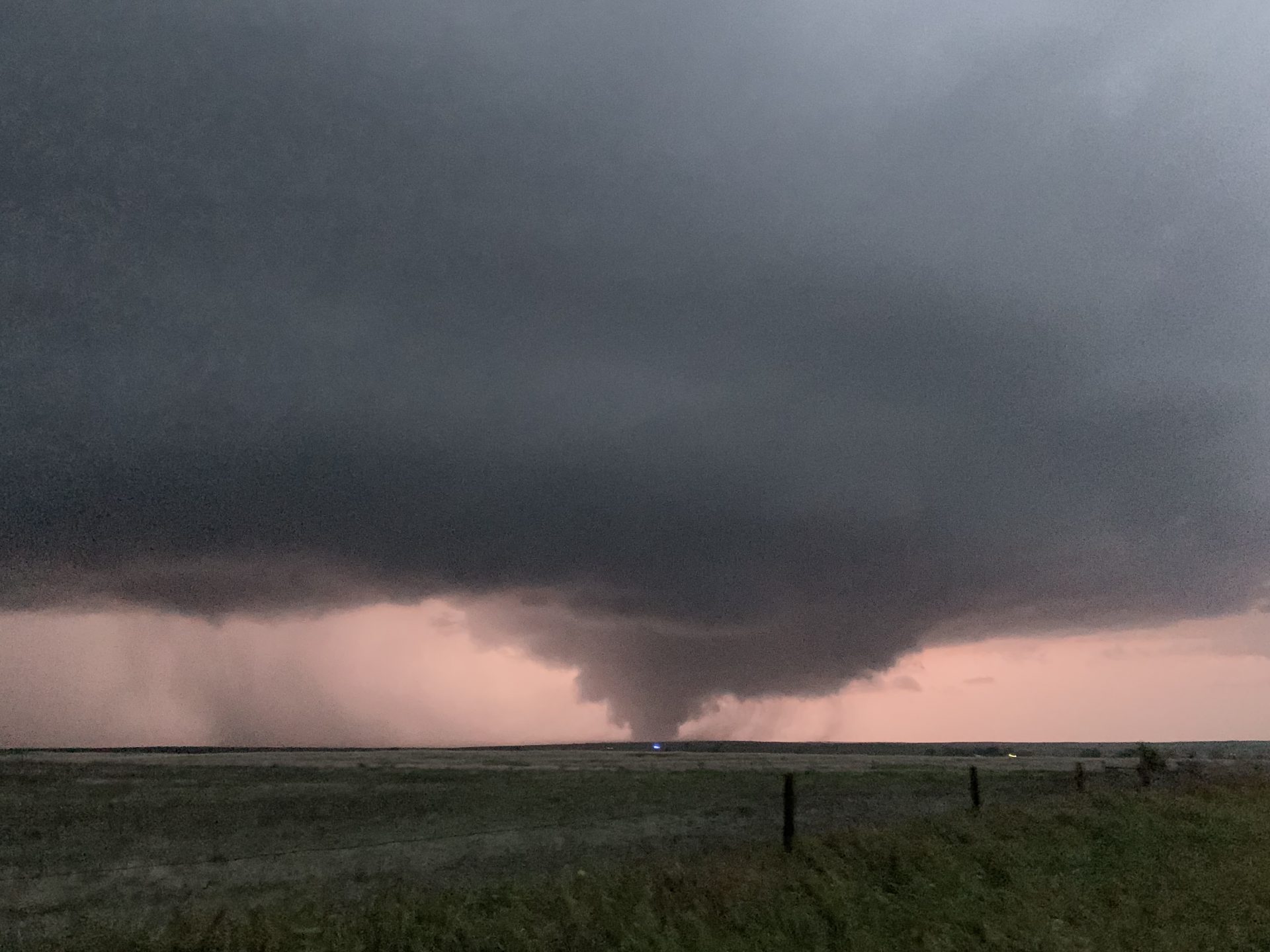
As the storm approached, we noticed that in the field directly in front of us, a hundred or so cows began to make a circle around their young. I’d seen this before — its typically in anticipation of a large storm impacting the herd. We began to joke that this circulation of cows would be the only rotation we saw that day, all the while starting to put Wichita into the GPS and buckle up for the ride home. At the last second, I noticed a new warning come across my phone screen: “confirmed tornado”. I was unconvinced (often even “confirmed tornadoes” in warnings aren’t really tornadoes), but we decided to take the road we were on about seven miles west to check it out. Conveniently enough the road would take us right to the circulation, so we figured we’d get a good view. At the same time, a picture came across Twitter showing a large black mass in the middle of the rain that had been taken from some distance away. We were still unconvinced, as from our own perspective all we saw was a large RFD cut and some heavy rain. We pulled into town near Canadian, Texas and saw what I assumed to be the RFD wrapping around a large mesocyclone coming towards us. I was wrong.
We found a small parking lot to stop in and let the mass cross in front of us. The swirling clouds in front of us took up the whole sky, and we quickly realized that the deafening roar we were hearing was the sound of a half-mile wide strong to violent tornado passing less than a quarter mile in front of us. At this point, adrenaline took over as we watched in shear awe. I’ve seen motion like that in a tornado once before: El Reno.
As the tornado passed in front of us, chaser Rob Hall was treated to an absolutely breathtaking view of the violent monster.
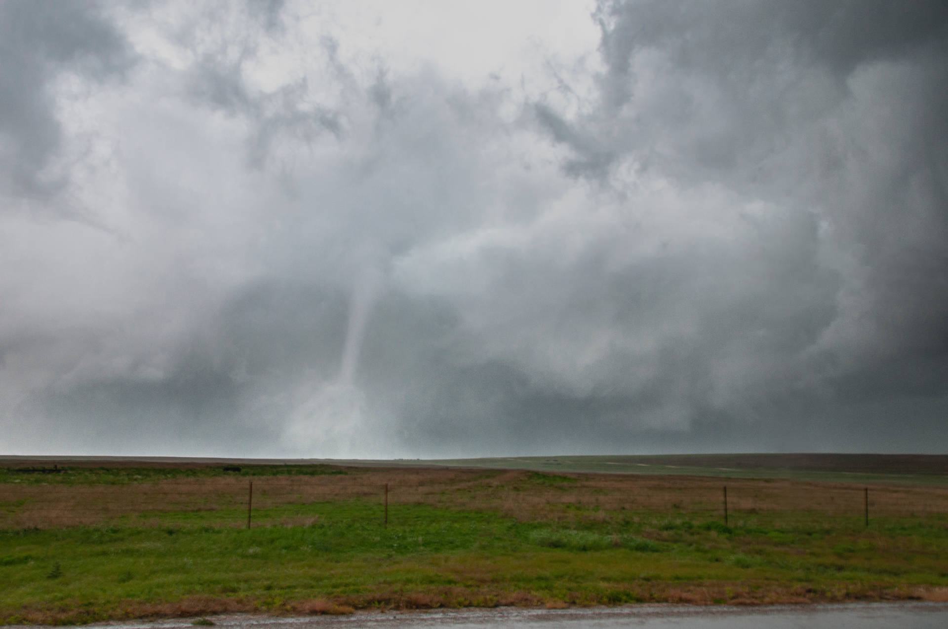
As the tornado continued to slide east, we realized that the road adjacent to the parking lot would parallel the storm. We continued down the road, watching as the RFD eroded the entire mesocyclone, leaving a tall, striated, swirling updraft above the wedge tornado. We stopped and I snapped a couple of stills and took about 25 seconds of video before deciding that this was something I needed to simply put my camera and phone down for and enjoy in the moment.
Soon thereafter the tornado began to rope out, leaving a gorgeous white elephant trunk/stovepipe atop the remnant cloud mass associated with the wedge. At the surface, a strong drill-bit was visible. This was, start to finish, a dream tornado.
Once the tornado roped out, we hopped back in the car and continued on with the storm, which was crawling along at about 25 mph. Considering we’d expected storm motions to be on the order of 45+ mph that day, this was a totally unexpected and pleasant surprise. What was not a pleasant surprise though was realizing that when I put my camera down in the car following the tornado, I managed to flip a switch or two and mess up the settings, rendering it useless for the rest of the day. This would prove costly, as the storm had no intentions upon letting-up.
As we continued along, we were forced to lose the storm momentarily due to some poor road options. Upon regaining the storm, we were treated to a rapidly rotating wall cloud with condensation fingers occasionally touching down. Given my lack of available DSLR and the transient nature of these fingers, I lost track of exactly how many of these instances were truly tornadic — there were definitely a couple however. We continued on with the storm and watched as it put down two super-brief cone tornadoes in the fields in front of us.
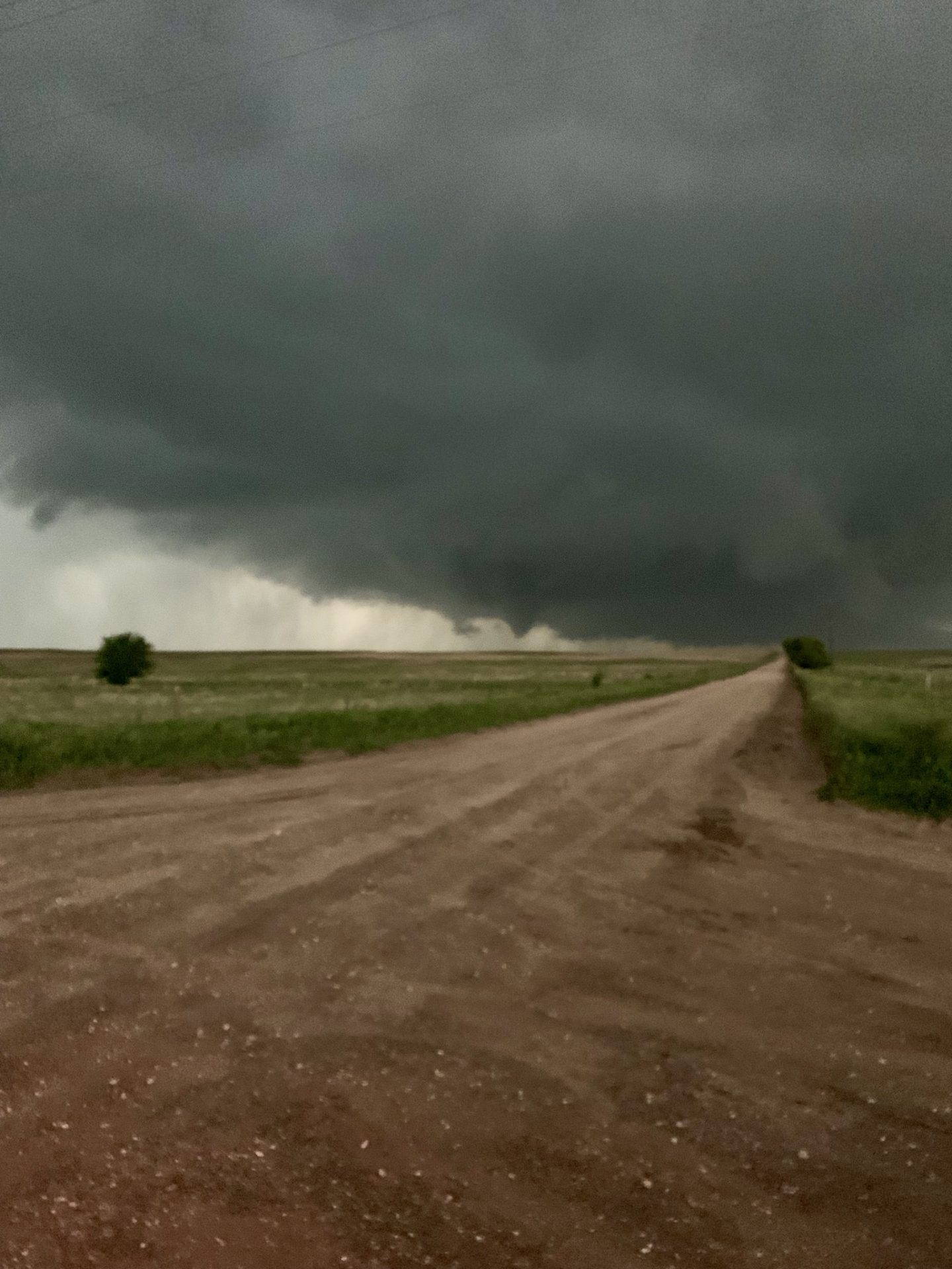
As the sun began to set and the roads became a little more scarce, the storm become a little tougher to track. We drove around a bend to try to get close to the storm to discover a series of small hills obstructing our view. As we found a road to take us back towards it, a large tornado was visible to our north. This was the absolute perfect tornado; a strong, backlit stovepipe and sometimes wedge with nearly no obstruction by rain underneath stunning structure. It looked like the cover of a textbook. I was able to snap a few phone shots, but am absolutely gutted that I was unable to use my DSLR. This was a career-making scene.
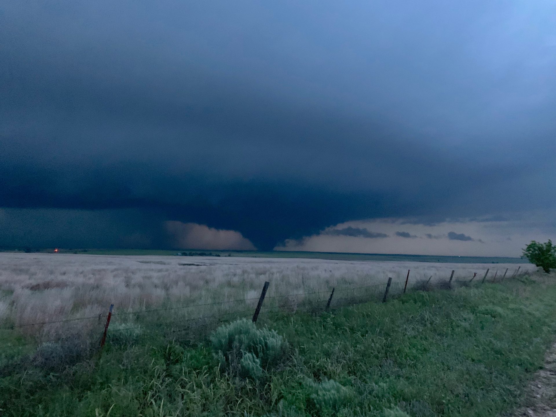
At the same time we were watching the tornado another chaser named Blake Naftel captured absolutely incredible video from a position closer to the circulation. This is honest to God probably the best tornado video I’ve ever seen and I am immeasurably jealous of his view. We were a couple miles further back.
We watched the tornado for 20 or so more minutes before losing it in the road network and the dark. After perhaps the greatest day of storm chasing I’ve ever experienced, we made our way back to Wichita for the night. Persistence and patience paid off.
Community Comments
There are no comments on this post
Want to leave a comment? Join our community → OR Login →